WRT V, Part 3: Of Sorrow and Triumph

This is the third in a three-part series. | Part 1 | Part 2

On the second to last day of my road trip, I cross South Dakota from southwest to northeast, almost entirely on back roads. I start in the Pine Ridge Reservation, which I expect to be jarring. It is.

The first markers of the new world I enter are the roadside markers reading “Think” and “Why Die?” While they are part of a statewide program to memorialize drunken and other reckless driving deaths, they are legion on Pine Ridge. Trailers begin to appear alongside the road, almost all in a state of decay, some fitfully patched up, others crumbling into these hard, rolling hills. In the town of Oglala, they just densify, each yard collecting broken down vehicles, mined for parts to keep one running. Drivers honk at the stray dogs who run in front of cars. A few men walk down lonely stretches of highway with no obvious aim.

The town of Pine Ridge stirs to life on this Sunday morning, a few kids ambling up streets and a group congregating outside a church. The reservation’s schools and health center at least look shiny and new, and the town now manages to offer some basic necessities in business and a few apparent research operations or other outposts from the outside. But it is still a tenuous borderland, still struggling to resist the entropy and despair that hang like a pall over Pine Ridge. There is one growing type of business that shows sign of new entrepreneurship: cannabis shops.

A few miles further east, I come to Wounded Knee. Here, in December 1890, over 140 Sioux camped beneath a white flag were slaughtered by the US cavalry. The massacre was the final blow in the Plains Wars and the end of an era, the frontier closed and reservation life made universal. Whispers of a mobilizing ghost dance spooked the Army, and after a single mystery shot, the guns above the creek blazed indiscriminately, killing Native men, women, and children, along with a number of US soldiers through friendly fire in the bloodbath below.

Today, a single sign by Wounded Knee Creek marks the site of the massacre, and a still-active cemetery atop a hill hosts the mass grave at its center. All is quiet when I pull up, but my arrival sparks some activity. An older man walks up the backside of the hill, introduces himself as the cemetery’s caretaker, and shares its history. His great grandmother, he says, is the one who showed another Sioux chief the blood coating the snow a few days later. He is reverent, adds some words in Lakota, though he also laughs easily as he talks of his grandchildren, for whom he needs to buy some Pampers.

Next, a younger man in a well-loved Seahawks jersey joins him. He adds some details on the 1973 occupation of this site by the American Indian Movement and subsequent standoff with federal forces. He had broken out of here to go live and work in Pipestone, Minnesota, but he is home to help restore water to his mother’s trailer down below the hill. He sells me a dreamcatcher. As I leave the site, two women with a young child arrive and begin setting up a table to peddle additional wares. For a variety of reasons I normally avoid giving handouts, but I leave Wounded Knee with a lighter wallet and no qualms about it.

Over these past two hours I have borne witness to an American moral disgrace. In some ways the tales of Native resistance and a delicate dance with an unbeatable government power take me back to the highlands of Chiapas in Mexico, right down to the vendors profiting off queasy, sympathetic tourists like me. But the affluence not far up the road seems to have particularly perverse effects on Pine Ridge, where residents can buy into one or two of the markers of modern American life but none of the rest, or are left with the detritus of a throwaway consumer culture and the accumulation of failing junk. I could haul in statistics on astronomical unemployment or obscene maternal mortality or life expectancies in line with the bleakest corners of sub-Saharan Africa, but my eyes are enough to capture the depths of the perdition here. Forget becoming great again: the US will be great when it can prove Pine Ridge is not a permanent state.

When I drove west in 2020, I struggled with questions about the state of the world, wrote moody fiction about a struggling soul who brushed up against the horrors of Pine Ridge. This time I drive freely, unburdened by what has been. I have borne witness, know I will find the words to capture this time on the edges of American life, a solo traveler drifting through and blending in with different worlds. I have a job in which I help chip away at the troubles in these lands, such as an outsider can. I am easing through, in control, pushing at edges and turning my eye my one great looming doubt, the place where my pursuit becomes tentative, comes up short.

As I go I listen to Hillbilly Elegy, now as good a time as any. The politics slip in here and there but the book is fundamentally an account of a broken boyhood, of one kid’s escape from a predetermined fate. JD Vance is the grandson of migrants (the irony drips through here), uncouth Appalachian Kentuckians who lit out for opportunity in an Ohio factory town, endured culture shock and their own demons but found ways, built lives. Two of their children lit upon upward trajectories, but Vance’s mother was the exception, the one who ran through men like tissues and lapsed into drugs. Young JD endures a constant rotation of father figures, jerked from place to place, unstable (despite some clear, precocious talents) until he finally lands in the place that has always been his most stable home: in with his Mamaw, the no-bullshit grandmother who sets a standard and holds him to it. She gifts him a world stripped of its ambiguities, clear in its expectations, no fleeting figures drifting through.

I feel stories like this deeply, am fascinated by how scars in youth can imprint themselves upon people. My own childhood was much happier than Vance’s, punctuated by a few acute jolts of pain instead of the near-constant anxious dread that probably made him the reflexive fighter that he is. Some scars linger, though, and he and I are not unaligned in some of our loose theories around the need for stable guides in a fluid world, of raising children to high standards, of the utmost importance of family life. How we have lived out that belief is very different.

I do not know if Vance has found the stability he craved with the choices he has made, will make no effort to judge his success or failure. But for my part there is no policy platform I would seek to impose on Pine Ridge to cure certain troubles of the soul, no rant about people whose views are different than mine. For me, before I ask what scenes like this demand that I do, I ask how I should be. In this case, the answer is to be a witness, to listen first, and then an attempt to uphold a faith in humanity through steady, daily work.

I have more pride than ever in the work I do because of some of the steps my office has taken over the past year to two to make good on some of these promises of greatness for people who deserve it. But the ties closest to home are still the ones that matter most. Trips like this one with an extended family are part of that work, bonds forged with people who are often not physically close but are some of my favorite humans. This whole year has been full of those journeys, and I cherish them all. And then there is my life in Duluth with my parents. Forget all the philosophical blather, forget the various expediencies: the foremost reason for my homing instinct in early adulthood was to live in joy with the two people who birthed me, even though our family unit is no longer. On that front, I have succeeded.

My project, however, is an incomplete one, and a gnawing void still looms as I dream of my own family life, my own investment in a future. What does it mean to want what I’ve been unable to find more than anything? It means I will pursue it with ever more vigor, with all the hunger, the joy, the panache, with everything I’ve articulated across all these journeys I take. I had thought this phase of life of outward journeys over the past few years may have been a distinct phase but now I understand it is in fact the project of a lifetime, an insatiable thirst for my world that will course through everything I do. I have built many of the necessary habits, slowly and fitfully over time. Whatever I might have believed before, I was never really ready. Now, I believe, I might be getting there. With that revelation I turn off the audiobook and coast into a Western sunset, my peace complete.

Western Road Trip V, Part 1: Blank Space

This is the first in a three-part series on a western road trip.

I go east for civilization, for history and culture and the roots of memory. I go west for new beginnings, for the freedom to make sense of that jumbled inheritance.

And so westward I go once again, across Minnesota and eastern North Dakota, back across these roads I am starting to know well. A road trip across the Dakotas and eastern Montana and much of Wyoming may invoke thoughts of monotonous and dullard landscapes, and there is certainly some of this. But some part of me is now drawn to this seemingly blank space, these hardscrabble towns, to people on plains that go on forever, once a frontier but now planted in the middle of an expansive land.

I fly across Minnesota and eastern North Dakota with few stops and spend an unremarkable night in Bismarck. The next morning I pay my respects at Salem Sue, the silent sentinel at the entrance to the West, and take in the first tentative buttes hinting at the hills and mountains to come. After numerous past visits to the South Unit of Theodore Roosevelt National Park, I swing off the freeway in Belfield and head for the North Unit. The basics here are much the same, badlands lining the floodplain of the Little Missouri River, scars and pockmarks interrupting the flatlands and beckoning the visitor in. Bison clump along the road and sometimes in the middle of it, and the campground is maybe half full on a Friday night.

I subject myself to a four-mile loop hike in triple-digit afternoon heat. The trail is mostly exposed, shooting straight up the sides of a coulee to vistas of the Little Missouri, where a few bison have taken refuge from the heat. Mercifully, the back side of the loop tucks into some juniper thickets that provide a reprieve from my blossoming sunburn, and I’ve found a campsite that has trees on all sides. Even the scattered sun hitting the hammock is miserable, so I park my camp chair atop my cooler in the shade of the trunk of the largest cottonwood I’ve ever seen and slowly rotate it to stay out of those cruel rays. My new camp gear is enough to earn me some sleep despite the heat, and I do not linger long the following morning, shooting west through the bleak impermanence of North Dakota oil country and down a long stretch of the Yellowstone River before a dive south into the Bighorn Basin.

Behind the Front Range of Colorado and the Bighorns in Wyoming, in front of the great ranges of Utah and Idaho and Montana and Yellowstone, is one of the emptiest corridors in America. It stretches from the Four Corners region in the south to the Yellowstone River in the north, 600 miles of parched country, some of the driest in the nation except along its ribbons of river: the Colorado and the Green in the south, the Bighorn in the north, these powerful waters punching through mountain ranges that separate the basins in this lonely land.

The Wind River Range is a protrusion into these inhospitable climes, thrusting south and east from the Tetons, and it is the 2024 destination for my annual hiking party. The Winds are not really near anything, and that is part of the allure for our journey this year. I spend my last night in the relative lowlands in a town selected because its name sounded fun. But it turns out to be more than that.

Thermopolis, Wyoming strikes me as a triumph of what the West can be. A town of just 3,000 people, it has the good fortune sit right where the Bighorn River slips out of the Wind River Canyon (the Bighorn and the Wind are, in fact, the same river), and the world’s largest mineral hot spring bubbles up beside it dumps on in. The area around the hot spring is a state park, guaranteed free for use by an age-old US government treaty with the Shoshone and the Arapaho, and I happen to visit during Discovery Days, which has a host of Native families picnicking on the sulfurous grounds around the spring. On this 100-degree day I am not too enthused about a dip in 105-degree water, so I make do with a stroll about to drink in the scene, and am too late to see the town’s top-notch dinosaur museum, too. Downtown Thermopolis has bustling shops and a surprising degree of culinary variety and a respectable brewery, where I post up at the bar and meet a couple completing the woman’s cross-country move to be with her snowboard guide partner in Jackson, and later two fishermen from Cheyenne. The snowboarder wins a few hundred dollars in a dice game jackpot, and the five of us watch Olympics and play dollar-ante dice games after that. It is a night well-spent in a town that pulls together the various strands of Western life and makes them into something whole.

From Thermopolis I head up canyon and into the Wind River Reservation. Here the Northern Arapaho and the Eastern Shoshone have land along the Wind and its merging tributaries with names like Poison and Badwater Creeks, which are in fact the two streams flanking the town of Shoshoni. This is deep rural country, though larger towns like Riverton and Lander have cropped up just off the reservation checkerboard and provide some services. From here I head up the old wagon trail route over South Pass and turn off on a steadily deteriorating dirt road into the Wind River Range, where my backpacking party will head for the Cirque of the Towers.

The rest of my fellow hikers head back to Salt Lake City after our hike, either to fly home or to carry on with their van life adventures across the West. My road back, however, is a long but purposeful one. After my descent from the Winds I head east to Casper, over rolling steppes of Wyoming sagebrush beneath moody skies, a pinprick within the great openness of the West. Early 1800s explorers called this land between the 100th Meridian and the Rockies the Great American Desert, and though it can be monotonous, the austere beauty here fills some hunger, some knowledge that these wastes hold some secrets and that crossing them can unlock some greatness.

I stop at Independence Rock and the National Historic Trails Interpretive Center, markers on old roads west, monuments to the toll these lands once exacted on those chasers of western dreams. Now, I shoot across them in a matter of hours, endure dreary Casper and then spend the next night in Hot Springs, South Dakota, where I see a collection of mammoth remains interred here on the southern end of the Black Hills. Most Western towns tend toward the simple, the impermanent, just the basics set up here to provide the necessities. But they also feel the past deeply, their stories told by the events that once happened here, and they guard these stories better than in the east or the far west where it might be paved over, subsumed by the march of progress. Instead progress drifts through here from time to time, leaves its mark but tends to move on, and the West eases back into a more timeless state.

The next morning I head toward the Pine Ridge Reservation, an experience that deserves its own post. But after that the rest of the drive across South Dakota passes easily enough. Grazing cattle beget sunflower fields beget corn and wheat. There is some momentary Badland delight before Kadoka, a swing past a second Dakota capitol building, and a skirting of some pleasant lakes to break up the endless fields and tired farm towns with a few nice new houses on the outskirts.

I spend my final night of travel at Lac qui Parle State Park, just across the Minnesota border, in a walk-in campsite amid prairie grasses with a view down to the lake that speaks. It is a perfect evening, and I write easily, the crickets amid the oak savanna pulling me back to some of my deepest-rooted snippets of memory, of warm summer nights outside Madison. (Wisconsin, that is: Madison, Minnesota is the nearest town to Lac qui Parle.) The campground is quiet, mostly empty, but a couple of fires crackle and a warm glow emanates from the camper cabins. A few Pleiades streak overhead. Worries drain away, nagging doubts fall into nothing. I have faith and I have a mission, and a blank space in which to write a name.

Part 2 is here.

Up in the Air

It is with some regret that I choose to fly for this year’s western hiking venture instead of taking to the western roads yet again. Rereading the account of my brooding deep-pandemic self in 2020 or my more mundane appreciation of such roads during my 2021 jaunt has me yearning for some of those cliches about western travel that are true because they are real. A recent Ross Douthat column whose sentiment I support seemed to scold my decision-making: “If you do not drive your country’s highways and byways, what path do you have to a nonvirtual experience of the America beyond your class and tribe and bubble? If you have strong answers to both questions, good. But lacking them, you should give the open road another look.”

A Saturday spent shuttling my dad from one end of northern Minnesota’s Kekekabic Trail to the other only renews this hunger for ribbons of asphalt and gravel. It is a nine-hour dive into the wilds of Minnesota’s north, and I bob and weave along two-lane highways through small towns, some humming with midsummer tourists and others fading back into the woods. Isabella has become a ghost town, while the cluster of bustle on the central Gunflint Trail could use a name on a map, and Ely straddles two worlds. Car travel frees me to eye the wreckage of the Greenwood Fire and drink in the cool lake air of Grand Marais, and to swing off to Sugarloaf Cove, where I can meander down the beach and flip open a notebook to record a few stray ideas. We writers are suited to modes of motion with spontaneous spurts and chances to suck up little details; it is only from these mined nuggets that we can later create grand arcs and sweeps.

While much of America has retreated from air travel, I have spent more time on planes over the past year and a half than at any point in my life. A healthy chunk of that was work-related puddle-jumping to Milwaukee, but I’ve found my way to destinations across the country, too. For the seasoned veteran, air travel is both simpler and more refined, inspiring in its God’s eye view but sapped of the details that allow for immersion and meditation. By plane I give no mind to the fortunes and failings of the towns along the highway, to the Native American reservations I skirt, to the stray roadside attraction that may worm its way into my mind. I bliss out, catch up on some reading, and flip the mental switch to begin living in the world where I’ve landed. It is a simpler, more self-absorbed way to travel, any interactions bounded by the metal tube we share and devoid of any relationship to the landscape around us.

Nor have I ever known air travel as a venture of true leisure and opulence. I have only dim memories of flights before 9/11 and its subsequent security cattle pens, most of which involve my nine-year-old self vomiting into a bag on a bumpy flight from Duluth to Chicago. I’ve had only brief brushes with business or first class, and while a free drink or two is nice, it is hardly a signifier of great luxury. For most of my plane trips, I join the unwashed masses in crunching my knees into ever-shrinking spaces and hoard my bag of nuts and cup of juice. Air travel is also prone to occasional great indignities when the plans go awry, whereas the driver will simply audible and find a detour or sub out a cranky rental car.

I romanticize the road trip, of course. This year’s hike is in Colorado, and somehow the tamed fields of Iowa and Nebraska do not inspire the same sense of frontier freedom as the Dakotas or Montana; time, scarcer and more precious amid a series of new pushes in life, has me settling for the two-hour hop to Denver. I will not miss the zombified state brought on by the eastern Great Plains, nor jockeying for space with long-distance truckers, nor the increasingly antsy push toward home of a final day on the road. These ventures have resulted in two busted windshields in the past three years, and at times I am left with a choice between splurging on an uninspiring roadside hotel or setting up a tent in a campground where I will be serenaded all night by the dulcet droning of RVs. But this decision is more profound than any convenience-seeking or aesthetic impulse: on my last solitary venture I decided that it would be my last one of that nature for a spell, and that is that.

Taking to the air seems a fitting way to head for some of the highest peaks in the lower 48 states. This year’s hike, on the Colorado Trail west of Leadville, will take place entirely above 10,000 feet in elevation, in the shadows of Mount Massive and Mount Elbert, Colorado’s two highest points. It will be a test of the lungs, and if we do indeed try to summit both peaks, a test of the legs as well. I will achieve a new cruising altitude and see just how hungry I am to reach new heights. Off I go, a new adventure beckoning.

WRT IV: On the Road Again

This post is the second of two on my 2021 western road trip. Part 1 is here.

For the fifth time in six years, I am headed west in summer, and for the fourth time, this venture comes by car. In part, it’s a matter of convenience: travel from Duluth by air would still take a lot of time, and it allows me to ferry objects like bear spray and fuel canisters that my plane-bound fellow hikers cannot. But I have also fallen rather deeply for the roads across the high prairie, for the open skies and the baking sun, for the sudden anonymity found in rest areas and scattered parks across badlands and foothills of great peaks. It is my own little nod to the myth of the West, a pursuit of the frontier in a world that now disdains them. To drink its possibility, if only for a little while, intoxicates.

I orchestrate a work trip across central Minnesota the day before my scheduled departure, and upon my release from those obligations, my trip starts in a traversal of mind-numbing St. Cloud and up Interstate 94. A malign haze has hovered over Duluth during this summer of fire, and upon first viewing, the big skies of the West are no different, shrunk down to size by the same dark cloud. The view from the 12th floor of the Jasper Hotel in Fargo, which should reach off to eternity, sometimes dies as close as one block away.

Still, thanks to some recommendations from a native son, Fargo proves it’s much more than a stereotype from a movie in which it didn’t really figure. Its downtown is booming, bustling, and filled with both newly developed and tastefully rehabbed old storefronts. The Jasper is chic, and the beers at Drekker Brewery, a former train maintenance facility, are top-notch. Having crossed the Red River into a red state, concerns about Covid have seemingly ceased to exist. My whole stay there feels like a throwback to sometime in my mid-20s, free to enjoy certain novelties as if they were new again, if perhaps shrouded in an uncertain fog.

Beyond those few square blocks of downtown, though, Fargo’s sprawl is dismal, and the smoke has made eastern North Dakota, one of the most boring landscapes on earth, even more boring. I drive on without stopping. For my listening pleasure, it’s some Plato on the prairie, a world away from the soybean fields I pass. But as usual, the rising hills beyond Bismarck signal the start of something new, and I pause to pay my respects to Salem Sue, the giant cow gateway to the West.

Last year, when I visited Theodore Roosevelt National Park, it felt like I had acquired a private 70,000-acre retreat. Across a two-night backcountry stay I saw only scattered visitors and three bison. This time, on a three-hour visit in which I don’t go over a quarter mile from the road, the cars crowd in, and the bison number in the hundreds. The combination of animals and humans makes for slow going, and the drought-plagued Little Missouri River is a sorry shell of its usual self, but my ventures somewhat off the road, both down Wind Canyon and out to a promontory off the Boicourt Trail, remind me why I fell for this landscape so completely a year ago. Its tumbled badlands still offer up that perfect mix of forbidding austerity and teeming life, an apt summation of the West and all that it has meant. I’ll be back again.

On this night, however, I push on another hour to Makoshika State Park, just over the Montana border and through the shabby town of Glendive. My campsite up Cains Coulee is a bit drier than Theodore Roosevelt and lacking in bison, but the things that make that park great apply here, too. I feel a bit silly as the lone tent camper surrounded by four RVs on my little circle of the campground, but overcome a tent malfunction to enjoy my dinner and loop up the bank of the coulee past the vertebrae of a hadrosaur for a few sips of mezcal from an overlook above my camp. The sun fades away behind a ridge and into the haze as my legs dangle off a bench made ever higher by the steady erosion of the badland dirt. A thunderstorm strikes not long after I return to camp, and I make do with a writing session in the car, the stressors slipping away as I fall deeper into this trip.

Evenings in car campgrounds in the West are inevitably spent among a unique subset of humans known as RV people. RV people are couples with an average age in their 60s, probably own a dog, and usually come from rural or semi-rural areas of non-coastal states. They are unfailingly nice and always make small talk, usually expressing something on a spectrum between admiration and concern for the choices of us tent people. Their lifestyle does have a certain allure. They have the comforts of home while living itinerant lives, a convenience that allows my three neighbors at Makoshika to just pull back the blocks holding their tires in places and roll off in the morning while I putter about stuffing various fabric objects back into sacks. On the other hand, my time among them involves being lulled to sleep by the dulcet drone of generators, their beds look rather sucky for anyone over six feet tall, and something always seems to be breaking in those big rigs. RV drivers also run the risk of being that big vehicle that clogs the ascents of mountain passes or piddle along at 18 miles per hour on their way out of Theodore Roosevelt, both prospects that mortify me at this stage of life. We’ll revisit these biases in a few decades and see if they still hold.

I spend my morning hiking Makoshika. The first stop is the Cap Rock trail, where I go in search of a natural bridge but see it only from the top and from some distance, as a family and I are twice thwarted by sloppy slides down the infamous, sticky mud of the northern badlands. Enough of this: I drive to the end of the road in the park, a horse trail that rides along a high ridge and feeds out to an overlook named Artist’s Point. The vistas along the way match those in most any national park, the baroque twists of this furtive land weaving out in every direction. There is a campsite here, tucked in a pine grove atop the cliff, and even with no convenient water, I file this one away for some future venture.

The high plains keep me alert as I drive west toward Billings, up and down the washes and along the Yellowstone River through towns bearing names of figures from the Plains Wars, some of whom appear in my audiobook choice that carries me through the rest of the trip, The Heartbeat of Wounded Knee. Its tone is a necessary corrective to the common lament about the Native American experience often served up in learned circles, and one I was drinking in fully on my trip through here last year. Yes, it is a sad tale of many deaths and betrayals and declines, but it is also one of perseverance, of continued existence even in the face of improbable odds. The message from its Ojibwe author, David Treuer, is, well, truer and more heartening than the easy cynicism of privilege-checking progressive thought.

My hiking companions on this trip are forced to come from Denver, the nearest place they could guarantee a car rental, and Uncle Bob calls to say they are three to four hours behind my pace. I take a detour to Pompeys Pillar National Monument, a promontory above the banks of the Yellowstone where one William Clark, split from Meriwether Lewis to explore this river on his return from Oregon, graffitied his name on the rock. A jog up the stairs to the top of the rock wakes me up, and a stroll through the cottonwoods along the riverbank has me feeling fresh. This pleasure fades some in Billings, whose dust- and smoke-choked strips I negotiate to collect some bear spray for our party. I worry the West is fully shrouded in wildfire, but an hour later, in Red Lodge, I see the bluest sky I’ve seen in weeks.

Red Lodge is a resort town, which means that, unlike the dismal highway strips I’ve traversed over the past two days, it has actual charm. Boutiques and restaurants line Broadway through its center, and its occupants range from wealthy tourists to hordes of motorcyclists to ski bums scraping along through the offseason. Bucolic scenes in the West, however, come at a price: $350,000, namely, for in-town, bland, out-of-date homes. Red Lodge also suffers from the same Covid Era crisis of rural escapes everywhere: lacking workers, many of its eateries close early, and the milling throngs wait in lines for the few places that are open. As with my fellow hikers’ journey from Denver, nothing is as easy as it used to be.

Our sojourn in Red Lodge provides us with another, less savory taste of Western life: an encounter with small-town police, who prove noxious busybodies as they harass one member of our crew the night before we begin our hike. Upon our return to Red Lodge later in the week, we make a joking show of checking every light on my car, and I put it in cruise control at 25 down Broadway. It may not have been excessive: as we leave dinner at a restaurant, we see the police fly off a side street and nail someone else. Gotta hit that quota, I suppose.

In search of some variety, I choose a longer road home: instead of plowing straight back east along I-94, I’ll swing follow a more southerly route to knock off a few new scenic sights. It doesn’t quite go to plan. Due to fires, I am denied a two-lane side trip across the Crow and Northern Cheyenne reservations on US 212 and forced to swing south on I-90 through Sheridan, Wyoming. Still, the Big Horn Mountains above Sheridan enliven the raw high plains, and the Wyoming wastes encourage a certain awe. I leave the freeway to stop at Devils Tower and circle the great butte on foot, stretching my legs amid 95-degree heat and hawks on updrafts and Native American prayer cloths and the crush of tourists from around the country. The Black Hills are swamped with motorcyclists in town for Sturgis, joy-riding here and there and everywhere. I have dinner on the Wall Drug strip in Wall, South Dakota, which is an experience if nothing else, and from there make my way south into Badlands National Park.

I arrive at Badlands near sunset. Ethereal beams from the sun filter through the clouds and bring a grey-pink light to the craggy slopes. Looming thunderheads light up in the sun’s presence, and as I wind my way along the park’s highway, the sun turns to blood red as it peeks between clouds. A prairie wind flits across the whole landscape, and here and there travelers have stopped atop the craggy landscape to sit and drink it in. I am loath to rush my way down the road, but nightfall is quickly shrouding the slopes in darkness, and for my trouble the rain begins just as I park at my very exposed site in the car campground. I deal with bathroom tasks and wait it out beneath the picnic shelter, watching the great thunderheads roll through before I set up camp by headlamp. I nod off as the day cools into a bearable temperature, content with a final night in a tent.

There is nothing to say about the rest of the drive; the road from the Badlands to Mankato, Minnesota, is deathly dull, before the banks of a low-water Minnesota River provide some intrigue for the final push into Minneapolis. This part is just the down-payment before cashing in on the rest, the West in all its stark beauty and forlorn silence and the crowds that come to seek it. The open road beckons, and I know I’ll answer its call again.

Rankings of Highways Heading Out of Duluth

This post is brought to you by the Youth Hockey Hub High School Hockey Podcast and my countless drives out of Duluth for work purposes over the past four and a half years to every small town northeast Minnesota has to offer. (Except Meadowlands. I remain convinced that Meadowlands is a mythical place and does not actually exist.) To qualify, a road must have a legitimate and distinct destination, thus ruling out mere connectors such as Minnesota 194, parallel roads such as the Jay Cooke portion of Minnesota 210 (pretty as it is), or the various township line roads that sputter out a short ways north or west of the city.

  1. Minnesota Highway 61 up the North Shore. Was there ever any doubt? Bonus points to those who take the Scenic Highway instead of the expressway to Two Harbors, but even the fast road provides a few decent lake views and eventual access to one of the greater drives out there. Drawbacks: rubberneckers, crowds on certain weekends, the inevitable overflow at Betty’s Pies. Additional delights, beyond the obvious cliffs and surf and rushing streams: Cedar Coffee, surfers on Stoney Point, a few roadside architectural marvels, and Rocky Taconite.
  2. Highway 13 on the South Shore of Lake Superior in Wisconsin. It’s a less dramatic driving experience than the North Shore, but it still has its quaint towns and lake views, plus eventual sea caves and the Bayfield Peninsula.
  3. Minnesota Highway 23. An underrated road, as it takes the driver through the full history of industrial Duluth along the St. Louis River corridor, then climbs to a nice overlook up the valley toward Jay Cooke. Winds pleasantly through forests of the Nemadji State Forest from there, and while it turns into a more standard straight shot through a few lost-to-time hamlets after that, it redeems any possible boredom by heading through Banning State Park before reaching 35 again.
  4. St. Louis County 4 to Biwabik. The Island Lake causeway is pretty, of course, but I’m fond of the winding road through the depths of the Cloquet Valley, a stretch where the deer counts can reach triple digits. Additional highlights include the not-so-subtly-hidden pot farm and the occasional wolf sighting. There’s something peaceful about driving a stunningly empty road south as snow falls softly on the pines and tamaracks. (Can you tell I’ve driven this road often?)
  5. St. Louis County 39/44 (Jean Duluth and Pequaywan Lake Roads). Basically, a somewhat less scenic Highway 4 and even less of a destination at the end, though this may not be a bad thing. The back road up to the east side of the Range, or perhaps to Ely. Pluses: the Breeze Inn, little-used ski trails.
  6. I-35 South. Not thrilling, but it keeps you moving, and will forever be redeemed by that view over Thompson Hill that signifies homecoming for any Duluthian.
  7. Highway 2 East. The Superior slog drags it down, but after that it’s a passably interesting meander over toward the Brule River and eventually on to Ashland, and eventual UP destinations farther east.
  8. 53 South. Like 35, its most salient trait is moving people quickly, and it does so with little traffic. It does, however, require that long drive through Superior to get there. Was slower but somewhat more interesting in the olden days when it went straight through towns like Solon Springs and Minong. Gets some bonus points for how often I’ve driven it over the years.
  9. US 53 North. Instead of slow slog through Superior, this route gives the driver a somewhat faster slog through Hermantown, which manages to be more chaotic and tiresome and lacks the occasional harbor view. After that, it is mostly drudgery and crazy signs until one reaches the outskirts of Eveleth. It improves from there, both through history and a scenic new bridge and eventual lake country access, but there’s too much drabness on the front end.
  10. Wisconsin Highway 35. An endless death march through the strip malls and strewn out neighborhoods of Superior and South Superior, followed by two lanes of absolutely nothing before you finally get to the cabin country between Danbury and St. Croix Falls. Redeemed somewhat by Pattison State Park.
  11. US Highway 2 West. First, one must endure Proctor. (Or, alternately, Hermantown, if one comes via 194.) Then, a long, mindless plod across peat bogs, every minute spent in desperate hope of a passing lane. Mild pluses: the St. Louis River crossing and the mild improvement that comes in Itasca County when the woods grow thicker around Grand Rapids.
  12. Minnesota Highway 210 west from Carlton to Aitkin. The great, interminable swamp.

Yeah, this blog will get back to having actual content sometime soon.

Good Writing, 12/4/19

In my continued ongoing efforts to collect good thinkpieces and also keep this blog somewhat alive, here’s another collection of interesting reading:

First, in the New Yorker, M.R. O’Connor tells the tale of “dirt road America,” an effort by a man named Sam Correro to map dirt road routes across the country. His project, decades in the making, invites travelers to slow down and drive slowly, to explore the forgotten corners and backcountry secrets of a vast, sprawling country. His meticulous hand-made maps guide curious souls on a very different kind of American road trip.

Sticking with the travel theme, whatever one may think of Roger Cohen’s politics, there’s little doubt he is the finest prose stylist on the New York Times opinion page, and in this recent offering, he gets himself quite lost on a hike in Spain’s Sierra de Guadarrama, I can only hope that, if I am someday lost and losing hope, I too will start meditating on Hemingway’s short stories as I contemplate mortality. Often the greatest way to escape any ruts in the present is to reflect on the wisdom of someone who’s been in that same place.

Perhaps not coincidentally given an impending milestone birthday, I find myself reading a lot about social pressures that lead to delayed family formation and childbirth. Thanks to Ross Douthat at the Times, I went down this rabbit hole this week with three different articles. Douthat himself wrote from his usual conservative Catholic perspective on how the contemporary left, after a period when it was relatively supportive of the idea of strong families as a social good, has begun to rebel against this concept. As a complement and counterpoint, he also shared a 2016 critique from the left by Nancy Fraser, who talks of how neoliberal capitalism undermines family and community social structures. Douthat also recently tweeted this long, sprawling account titled “The Economics of Boomers” by Byrne Hobart. It’s a wonky economist’s perspective on how the economic history of the past 60 years is strongly tied to different phases of baby boomers’ lives, and how the political economy they’ve created defines the life choices of younger generations. Ok, boomer!

Finally, on a lighter note, northern Minnesota author Aaron Brown tells us exactly what an Iron Ranger is. At my core, I’m really not a cultural Ranger at all: I like urban life and have snobby tastes in reading material and food and drink. But I spend a fair amount of time on the Range these days, and I like hockey and beer and the outdoors, so I can usually slide in comfortably. Brown nails it: culture, in the end, forms the basis of these labels.

Until next time…

The Towns Down the River

My education on the travails facing St. Louis was a swift one. On a road trip there for a wedding last weekend, several family members, seeking some beer with which to amuse the group, ventured across the street from the hotel to a Circle K gas station. Each six-pack came to them one-by-one through a drawer from an attendant behind bulletproof glass, a security provision deemed necessary even on this unassuming commercial strip right off an interstate. Next to fried ravioli and Budweiser, St. Louis’s lingering image is one as perhaps the most complete representation of the crumbling of Middle America, a sign of what might await downriver for the rest of us if we’re not careful.

The population of St. Louis is down to about 300,000 from a high of 850,000 in the middle of the 20th century. Streets and buildings frequently nestle behind gates, the divisions of a third-world city brought right into a metro whose urban evolution has followed the same trends. Its many brick facades, I learn, are now often the most prized part of a house, and many get removed and shipped off for use elsewhere. Unlike many Rust Belt towns, St. Louis’s fate wasn’t tied to the rise and demise of a single industry; its struggles stem from the gradual decline of a range of industries and a steady stream of buyouts by larger multinationals. I now understand why Jonathan Franzen named one of his early novels about his hometown The Twenty-Seventh City to note its decline from a great American metro to a middling status. (My copy made this trip with me, but I never opened it.)

St. Louis also lacks the perversely romantic ruin porn of Detroit. Its greatest testament to urban planning failure, Pruitt-Igoe, is now partially repurposed and partially a vacant field. Pruitt-Igoe was to be the modernist model for how to build public housing: 28,000 units designed by Minoru Yamasaki, the celebrated designer of the World Trade Center in New York. Less than twenty years later the whole thing was demolished. The failure of Pruitt-Igoe is often billed as a failure of architecture; Charles Jencks, an architecture critic, called its demolition “the day modern architecture died.”

It’s certainly true that the complex suffered from shoddy construction, and that architecture alone cannot make good citizens in the way some of the more absurd modernist dreamers in that field liked to believe, to ruinous effect. But the greater tragedy of Pruitt-Igoe stems not from its design but from an environment that doomed it to failure: a crumbling economy, blatant segregation, poor city management that destroyed St. Louis’s tax base, and a political climate that had no desire to see public housing succeed. For those who defend those systems, explicitly or implicitly, the architects are a convenient scapegoat. The failures of Pruitt-Igoe endure, its ghosts appearing on the streets of suburban Ferguson in recent years.

As with Detroit, there is still plenty of growth and commerce around St. Louis. It enjoys a large ring of well-off suburbs where plenty of people, including some members of my family, have settled in to happy lives. But it is also an ideal study in how major trends, from economic centralization to government division, can be the lasting difference between cities that are challenged but thriving and those that have come to exemplify the worst of contemporary America. The St. Louis experience offers a compelling case for regional governance and an indictment of a range of incentives and policies, whether malignant or merely misguided, that created the divides of a power in decline.

I don’t want to linger on the negatives for too long. St. Louis has a dramatic arch, and two Grade A large city parks that date to its World’s Fair days, complete with a zoo and a botanical garden. The City Museum, which I explore with a couple of relatives after the reception, is a true marvel, a playground for all ages in the shell of an otherwise vacant old building, the wreckage of a shrinking city repurposed into tunnels and slides and other stray sources of amusement. I’ll be back here in the future, and I hope to find a few more worthy sights. But on this weekend I settle for rolling in and out in a heartbeat, with long drives across downstate Illinois and Iowa to slow down the time along the way. Rarely is it memorable, save for windows into the less dramatic but equally damning rural decay that line the four-lane rivers of commerce that have replaced the Mississippi as the lifeblood of these towns.

*          *          *

Some two hours north of St. Louis, on the banks of the Mississippi, sits Hannibal, the boyhood hometown of Samuel Clemens before he became Mark Twain. He didn’t live there long, but this town of 17,000 left an indelible mark on one of America’s most celebrated writers. Like any small town that has had a brush with fame (and many that haven’t but would like to think they have), Hannibal is all in on its famed son, with Twain kitsch and a full cottage industry around him on full display. We enter town down rather dismal, run-down streets amid a rainstorm, but downtown Hannibal is cute and well-kept, and the Twain Boyhood Home and Museum, which sprawls across several buildings and blocks, is worth the $12. We get a full overview of Clemens’ early life, and the town smartly keeps its emphasis on his early years which were so formative for his two best-known works, The Adventures of Tom Sawyer and Huckleberry Finn. Those two icons of American literature are clearly children of Hannibal, and each of the major figures in those books had direct real-life parallels.

Beyond Hannibal, Twain’s fortunes have risen and fallen over time. The museum acknowledges the controversies surrounding Huck Finn, both for its transgressive language at the time of its publication and its contemporary fall from grace for its repeated use of a word we now consider vile in polite speech. A panel in the museum shows dueling quotes from writers on this flap, with Toni Morrison blasting anyone who’d shy away from an accurate account of historical language and Jane Smiley suggesting that, if Huck Finn is the book that sets the context for discussions of race in America, it’s letting us set an awfully low bar.

Both points can probably be true. There are certainly more effective and searing testaments to the reality of racial conflict in America than the writings of a white man from over a century ago. The problem comes from trying to see Huck Finn only through that lens: it’s a major theme in the book, yes, and there’s certainly something to Huck’s growing understanding of racial divisions that readers can learn from, perhaps especially because Huck is by no means privileged but can still see injustice in front of him. (An exhibit in the Becky Thatcher House does a good job of laying out 19th century Hannibal’s class boundaries for a young audience.) And Twain also deserves judgment by the context of his day: sure, some language no longer resonates, but he was a dedicated and consistent champion of racial equality at a time when that was often a bold take. He wrote a book-length diatribe against the atrocities of King Leopold of Belgium in the Congo, and he blasted injustice around the world, from Boers in South Africa to servitude of Pacific Islanders in Australia. He also oversaw the rehabilitation of Ulysses S. Grant’s reputation through the publication of his memoirs, a vital corrective to a Southern narrative of Reconstruction as a failure and Grant as a bumbling and corrupt commander-in-chief. I have little patience for armchair critics of a man who consistently used his station to combat injustices everywhere.

Twain endures because he embodies the best of the American narrative. He is often wickedly funny, an astute observer of American reality using a vernacular, that, if sometimes less accessible now, was a vital step in literature’s move away from endless highbrow blather to something accessible to all classes. His realism was for everyone, and dedicated to a democratic spirit. He burst on to the scene documenting the freshness of American thought against stodgy Europeans in The Innocents Abroad, and he set his country to overcoming such ugliness as slavery and racism, which he himself had benefitted from as a child. In this vein, his great characters are adolescents: not yet fully formed, burdened by family history and their instincts but still capable of greatness or redemption no matter their backgrounds. Tom and Huck speak to the possibility of boyhood, and Twain’s nostalgia for his early days when a small-town American childhood blurred very real class lines. That formative experience may no longer be possible in the St. Louis metropolitan area, and if that is indeed the case, it’s a major loss.

A dive into a Hannibal childhood stirs some agrarian corner of my soul, itself grounded in an early-life sojourn in a town of 4,000 where I formed my first memories. As with Twain, that small town was my sandbox for my first steps into writing. This road trip’s final day includes a push through the land I associate with those early years: the hilltop farms and meandering coulees and oak savannas of Wisconsin’s Driftless Area. The towns here seem better kept, better able to avoid the shabbiness on display in Iowa or Missouri or, for that matter, northern Minnesota. On a golden early fall morning, I don’t much mind getting stuck behind a house on wheels as I wind up and down these verdant hills. These hills are reminders of a time when I, too, had no sense of the divides I can’t help but see now, and remind me that the dream embodied in Twain’s characters isn’t useless nostalgia, but a dream of how things could be.

Golden Land

This is the second in a two-part series on my recent trip to California. Here is part I.

The main attractions of my recent trips to California were its mountains and shorelines and deserts, but I devoted half of my adventure last week to the more populated portions of the Golden State. The jarring riches and contradictions of its natural environment match those of its people, who luxuriate in opulence or live in massive tent cities on its streets, extremes that a Midwesterner accustomed to a semblance of order needs some time to process. But all halfway decent chroniclers of travel revel in the dualities and contradictions they see, witnesses to the rich vastness of human experience. We can dive into urban chaos and venture off the grid and chew on it over time, slow thought exemplified after the mad rush in the moment.

I’m not very good at travel at leisurely paces, and in San Francisco, I have the perfect guide to facilitate a rush to drink in everything this city has to offer. My cousin Rob, an artist at his craft, gives my fellow Lost Coast hikers and I the grand tour. This is my third time in San Francisco in four years, and despite the inauspicious theft of all my camping gear on the first visit, it continues to deliver thanks to Rob’s curation. My first visit featured an unexpected visit to Pride Weekend and an escape to wine country, while the second was a moped-powered kickoff to another great adventure. San Francisco is a temperate city populated by extremes, stunning beauty and endless fog banks, mind-boggling wealth and its trappings twinned with the extreme poverty of tent cities where my old Eureka may yet live on. It starts with a Women’s World Cup watch party, meanders through botanical gardens and the cable car museum, and crosses that famous Art Deco bridge a couple of times, all before dumping me back at the airport all too quickly for everything but my wallet.

San Francisco’s true greatness comes through the things one consumes while in the city, and this is where Rob’s expertise is most useful. The crowning meal is the seafood feast at Bar Crudo on our full day in San Francisco after the Lost Coast hike, octopus and wine and crudo and oysters. But we also enjoy a decadent brunch at Brenda’s French Soul Food, with beignets and shrimp and grits, and a Greek fast casual rush to salads after four days of freeze-dried delicacies. For drinks, it’s an even wider-ranging tour: a mezcal bar, a cocktail bar on Russian Hill, a couple of neighborhood establishments, and a failed visit to the Hilton’s 43rd story, shrouded in fog. At its most ridiculous, there’s the Tonga Room: a former pool in the basement of a luxurious Fairmont hotel that now has a band on a moving boat in the pool, which enjoys periodic rain showers with thunder and lightning. A full pirate ship sprawls across the bar as a dance floor (complete with real reclaimed masts), there are tiki huts and real dugout canoes scattered about, and we have the privilege of tasting $17 mediocre mai tais. After bidding our older companions farewell on the final night, Rob and I wrap up with a nightcap at a beer bar from a group headquartered in Copenhagen. I’ve drunk it all in, all too literally.

Our trip to the Lost Coast involves a three-and-a-half hour meander up the 101, a highway that runs down the coastal spine of California. It’s a somewhat confused highway, ranging from six lanes to two on its trek northward based on what the topography will allow. It starts in ritzy Marin County, wanders up through Sonoma, and eventually arrives on the north coast. The road trip brings two familiar stops, the Russian River brewery on the way north and the Locals wine cooperative on the way south; I fly home with a few bottles stuffed inside my sleeping bag. Rob and I drive separately of the rest, freeing us to talk of baseball and music and for him to share the sad tale of Pete Buttigieg’s iMac. (Fresh off his Rhodes Scholarship, the future mayor gifted it to a teacher at his high school, who in turn passed it on to the sort of kid who might make use of it, a future Bay Area engineer; alas, it fell victim to a recent purge of the attic storage area by his parents.) The south end of redwood country is both as a dramatic and as kitschy as we’d hoped for, and we’re easily distracted by an endless array of entertaining sights. We spontaneously divert to drive through the Drive Thru Tree, a 2,400-year-old Redwood that some enterprising entrepreneur cut a car-sized hole through in some less environmentally sensitive era.

Big tree tourism aside, the economy of northern California is sustained principally by mind-altering substances. Somewhere in Mendocino County, the vineyards of wine country give way to businesses making puns about the herbal substances grown in greenhouses up in the hills. Over dinner in Garberville on the night before our hike, we share a cantina—the last place open in town, and still open only because they can make some money off of us—with a herd of Mexicans in stoner garb who populate the neighboring table. Connor, our Lost Coast Adventure Tours shuttle driver, regales us with tales of the marijuana industry and points out greenhouses not-so-secretly tucked away in the woods off the miserable washed out roads of this backcountry. He had teachers in high school growing plants on the side, he explains, and those smashed-in cars that litter the roadside here and there are the product of a land that doesn’t want many intruders. Connor speaks of Brazilian and Bulgarian incursions, all in pursuit of this ideal pot-growing climate, and laments the one-sided portrait of Humboldt County that came out of HBO’s Murder Mountain, a series that points out the region’s nation-leading disappearance rate and the places where the authorities will not go. Tales of rural Mexico come back to me, and not for the first time, I think the borders between our countries are sometimes far more arbitrary than many Americans would like to believe. Whatever one’s take on actual use of the drug, my two-hour meander through the hills only fuels my weirded-out feeling by the marijuana industry, both for its insufferable lazy stoner culture and the dark side of its industrial-scale cultivation that will likely go on whether pot itself is illegal or legal but regulated.

At its core, California is a state of escapes. It was the end of the line for Manifest Destiny, the Promised Land beyond the frontier. Its cities have always been some of America’s most alluring, even as they descend into crisis; one friend calls San Francisco utopia gone wrong, and Los Angeles dystopia gone right. And while we’ve tamed nearly every corner of it now save for a few Lost Coasts, that push to the brink is a constant, whether in Sacramento’s gold rush yesterday or the Bay Area’s tech industry today, or in the form of kids who try to pursue illusory dreams of stardom in LA. For all of California’s cool pretense, it is as neurotic a state as one can find, and if worldly glory isn’t there for the taking, it offers direct escapes to wine or IPAs or weed. California lives in the future, and that is not altogether a reassuring thought. The myth was long ago obvious to Joan Didion, and like anything built on a mythical future it neglects realities of history that formed it. Its myth was the American myth taken to its logical extreme, and its myth, like America’s, is coming due. At times I’m repulsed by the whole spectacle, but I can’t stop coming back for more hits.

Sacramento, my first destination on this trip and the last I’ll write about in my account, stands at some remove from this edge while still imbibing some of it, which may be why I liked the place. Sacramento is one of the thirty largest metropolitan areas in the country by any measure, larger than more culturally prominent peers like Pittsburgh or Vegas. Culturally, however, it’s dwarfed by the Bay Area and Los Angeles in its own state, and even San Diego in many ways. It is a seat of government with little in the way of major private industry, the rare California metro whose brushes with national attention, like John Sutter and the Folsom prison, are relics of the past. Its culture, my hosts explained, is a mash-up of Central Valley agriculture, Bay Area spillover, and a more rugged foothill culture stemming from the nearby Sierras. It’s also an ethnic melting pot, by some measures among the most integrated cities in the U.S., with large white and black and Asian and Hispanic populations. Syncretic places that don’t try too hard to be different have something going for them.

Compared to the chaos of San Francisco, Sacramento is a breath of fresh, if very hot, air. Its streets sit on a clear, leafy, clean grid. This is California, so it’s not cheap by any stretch, but it is still far more livable than the larger metros. It’s a flat city, with large swaths lower than the nearby Sacramento River, kept out of the city by levees. My host for the weekend recommends I drive up via a road along the levees of the Sacramento, and my journey feels like a warp into Southern bayou country with some citrus groves thrown in along the side, my rental car yelling at me every time I drift too far to the side in the narrow lanes atop the embankment. Rural agricultural poverty collides with riverfront vacation homes here, though the defining feature for most of Sacramento’s population is not one of these extremes but instead the identical suburban tracts in which I temporarily lose myself in Elk Grove on my drive in, and a heap of other cities I pass through the next day on I-80 on the way up to some breweries in the foothills. The extremes tell only part of the story.

My two hosts in Sacramento live different California dreams. My Georgetown friend Ben and his wife Etienne, plus 2-year-old Ella and baby Bo, host me both nights. Ben is the rare Hoya who settled down right away with a girl from back home, and while they have solid professional jobs and live in a pleasant East Sacramento neighborhood, their lives have a steady rhythm, child-rearing and delicious cooking and walks or bike rides around the pleasant grid. With them, I can lose myself playing with Ella, any uptight worries gone, back to the cradle, an instinct my inner cynic will always doubt but which my cyclical life will always turn back to contentment when I do my final accounting of pleasures and frustrations. Their deliberate domestic life, the California Dream of generations before, feels more and more like a bold or even radical choice, an attempt to restore the lingering wisdom of an old order that may or may not still be welcome here.

Meanwhile, Parker, a fellow University of Minnesota-trained urban planner, took the same prodigal son’s path and I did and found his way back to his hometown for a job in affordable housing development. If there is any dream of rescuing semi-affordable housing in California, it’s probably here, and in him I could see the same zeal that other non-locals ascribe to me when I gush about Duluth. He lives the urban single life in trendy Midtown, cultivates his status as a music connoisseur, and is my guide to quality Midtown bars and some breweries up in Auburn and Rocklin that meet with Rob’s approval as some of California’s best. They take different paths, but Ben and Parker are both exceptionally well-read, reflective people who are finding their purpose as they go. My people.

On a trip that featured a stunning hike and a dive straight in to one of the world’s great cities, some of my favorite moments came when we settled into Ben and Etienne’s porch, the kids in bed and the four of us free to debate this city and this state and what it means to find our ways in the world, the breeze pouring up the delta keeping us cool as we work through a few beers. I may not know who I am but I know where I am from, and that place, whether Duluth or Sacramento or Georgetown or Madison or Phoenix or a beach in Puerto Escondido, has nights like this at its soul.

WRTII, Part 2: East into the West

This is part 2 of a series on my recent Western road trip. Intro here, part 1 here.

My coastal forays complete, I’m now ready to begin the National Park phase of my road trip. I plan to visit four across the next six days, a bug planted by past brushes, the travels of others, and some Ken Burns documentaries. I follow a highway toward Salinas, congested only in the opposite direction, and turn off down a river valley. Here, I get my first look at California agriculture. Dozens of trucks sit parked next to a field, and a flag from Chivas, the Guadalajara soccer team, looms over them. (One suspects that mechanized agriculture would be a far more effective tool to limit immigration than a wall, if that is one’s thing.) It’s a drizzly morning, and the tops of the mountains are wreathed in clouds; to my right, the coastal range is green, while to my left, the range on the other side of the Salinas Valley is that classic California gold. My next destination, Pinnacles National Park, is up in these hills.

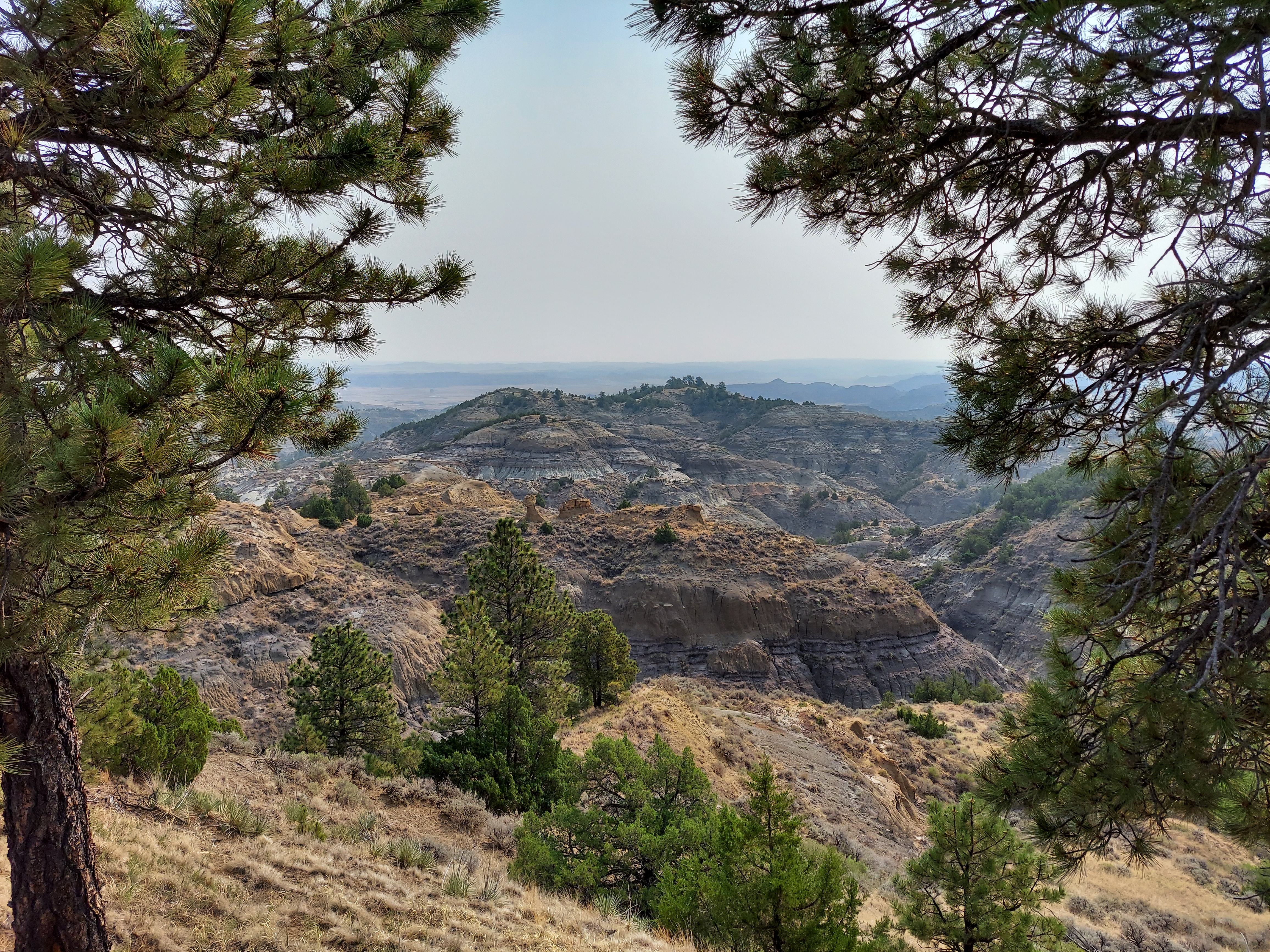
Pinnacles is one of the newest additions to the National Park System, a 2013 creation designed to protect a big, dormant volcano that was once down near Los Angeles, but has made its way some 200 miles north thanks to the San Andreas Fault. Its namesake is the set of towering rock formations at the heart of the park known as the High Peaks, where fat fingers thrust their way upward from the earth in an imposing array of jagged ridges. No roads cross the park, and its primary entry lies on the eastern side near Hollister, but I come in from the west through the town of Soledad. Beyond the rocks its greenery is traditional chaparral, a dry and scrubby landscape with stunted oaks and unexpected pockets of life, especially now in spring when the flowers are abloom. My access road is just one lane for long stretches, and pitches its way up through the hills to a lonely visitor center. No rangers are on duty, and a custodian waves me through and just tells me not to freeze. It’s 46 degrees when I park. Some escape from Duluth spring this vacation is turning out to be.

20180501_085742

I’m the second car in the lot when I arrive, and I have the first trail I explore, the Balconies Cliff and Cave loop, to myself. At the start it’s a wide, flat trail, but in time it switches back and wanders up a cliff for some respectable views of the main peak and a valley leading on to the other side of the park. It proceeds in the shadow of the sheer Machete Ridge, a popular rock climbing destination. The mist shrouds the high peak pinnacles, and this park, quiet save for the birdsong, has an otherworldly quality, like some land I would’ve imagined as a kid when mapping out some fantasy world in my mind. I descend from the ridge and make my way through a valley that slowly closes in on itself before I cove to an opening in the rock, a gate ajar in front of it. Time to explore a cave. My small flashlight is less than adequate, and I spent a minute trying to figure out how exactly I’m supposed to climb over the waterfall before finding the actual trail somewhere to its left. It’s a tight squeeze up a passage and over scattered boulders, but before long I pop up into the mist again, and slip through another crack between rocks on my way back toward the parking lot, which hasn’t added any cars since I set out.

The next stage of my hike takes me up the floor of Juniper Canyon before it rises up a long set of switchbacks into the High Peaks. It’s a decent prep hike for Angel’s Landing at Zion; while it has few sheer edges, it does offer a substantial elevation gain. Later, in the aptly named Steep and Narrow Section, a thick metal railing is a very welcome addition, both to pull oneself along and to prevent a fall. The climb up into the High Peaks is a reminder of the first rule of mountain climbing, which is that peaks are always higher than they seem to be, but the CCC-era marvels of engineering make it all easy.

20180501_105034

Some slight spits of rain start to fall as I reach the top, but it’s a pleasant sensation now that it’s warmed up some and I’ve worked up a sweat. The fog burns off as I make my circuit of the High Peaks, and I’m rewarded with good views in all directions. A small air force keeps watch over the heights, most of them hawks of various persuasions; I would like to think the larger birds in the distance are condors, but I’m in no position to say for sure. The foot traffic picks up some on my way down, and I settle in at a now-sunny picnic table by the parking lot to eat lunch and catch up on my notes.

I return to Soledad to gas up, then head south on The 101 for a spell before breaking east on California 198, which will take me all the way to my destination in the Sierras later this night. Having seen a big ocean and big rocks, I’m now ready for the big trees of Sequoia National Park. The first 40 miles of 198 are along a weaving mountain road reduced to single-lane misery by construction in places. Later, I hit California’s Central Valley: flat, filled with agricultural groves, countless more Hispanic farmworkers, and scattered, dust-choked cities. Nothing in Hanford or Visalia makes me want to stop and look around, so I just drive on, and begin my ascent by the Kaweah Reservoir, a pretty lake marred by a truly ugly collection of houseboats at one end.

I climb through foothills wreathed in fog, and random rain drops disrupt my new collection of bug carcasses on my windshield. A sign of more ominous weather events higher up? Sure enough: at the park entry gate, I learn that tire chains are a requirement to go any higher than my campground. I could head back to the nearest town, Three Rivers, and rent some, but between that inconvenience and the construction delays of up to an hour in each direction announced by sign boards for higher up on the Generals Highway, I concede my defeat to the Sierras. I won’t get to see any sequoias on this trip.

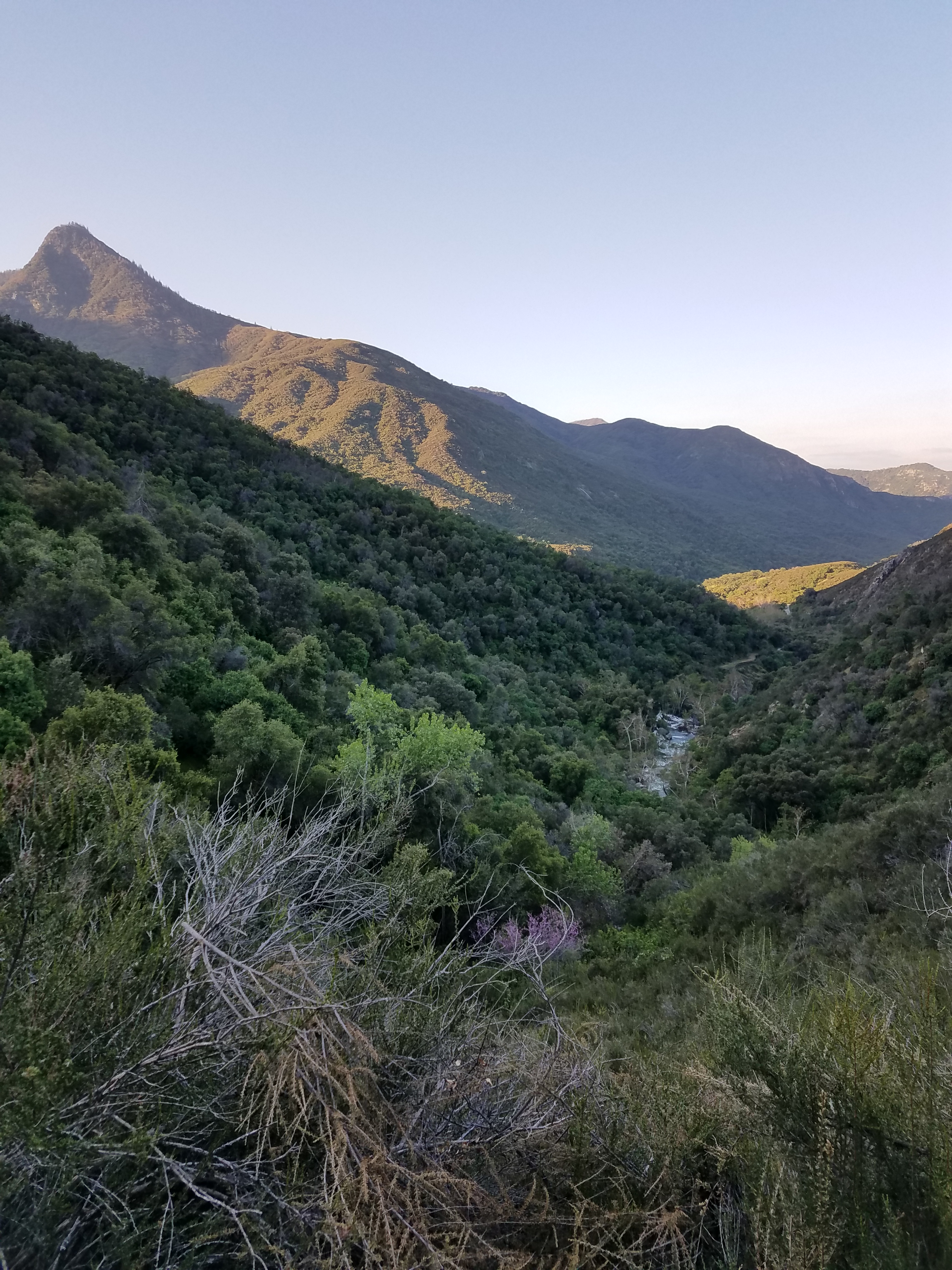
Still, I settle in for a night in the foothills. Potwisha Campground, whose name I still cannot pronounce, is nestled in the now familiar landscape of California chaparral. It is more verdant than at Pinnacles, with thicker foliage and the rushing Kaweah River right below the sites across the road from mine. The rushing river provides the soundtrack, but otherwise, it’s an unremarkable National Park campground that fills up with people who don’t linger much in the cool evening. After a frigid night, I take a convenient hike up through that lush chaparral, following a path that clambers along a ridge overlooking the Kaweah toward some waterfalls. I flush a bunch of bunnies but otherwise see no one until the tail end of the hike as I return to the campground. Today looks like a clear day, even around the highest visible peaks. Perhaps if I’d pushed it, I could’ve made it up to see the big trees after all. Instead, I turn my attention southward.

20180502_065656

The road between Three Rivers and Bakersfield, aside from the monotonous cropland of oranges and olives, is a rather dismal one. Everything is dust-choked and drab, and giant political signs yell their slogans everywhere. Even the wealthier homes look questionable, as if no one is really sure they belong here; the nonexistent flow of the Kern River through Bakersfield suggests that might just be the case. The guidebooks I’d consulted before the trip didn’t have a word to say about Bakersfield, its omission saying all there is to say about this city of nearly 400,000, but the locals are plenty welcoming when I stop for a classic California lunch at an In-n-Out Burger.

My path east from Bakersfield sees a sudden change in the terrain. Gone are the farm fields and chaparral, and the land is dry, mountainous, all covered in some shade of brown. A few stray Joshua trees begin to appear, and after a pause to get ripped off on gas in Tehachapi, I come across the largest wind farm I’ve ever seen. I’ve left California and entered the West.

A road trip across the rural West is a reminder of how much of the American economy still depends on logistics, agriculture, and extraction: practices that are afterthoughts to many city-dwellers. It’s not hard to see why the people who work one set of jobs now seem a world apart from those in the other, and why this is likely to only grow more extreme. The convenience economy of a San Francisco doesn’t require anyone to ever see a roadside fruit stand, a passel of parked trucks beside oil rigs, or the semis groaning their way up the pass on Highway 58 between Bakersfield and Mojave, unless they decide to clog the passing lane at 45 miles per hour to get around the even slower trucks working their way east.

Few forces have had as dramatic an effect on the American countryside as the development of expressways, whether they are part of the formal interstate highway system launched in the Eisenhower era or just a state highway like Route 58, which Caltrans has slowly rerouted around the major towns to allow for free-flowing movement. They resulted in the complete reorientation of rural America, as Main Streets were supplanted by exit ramp strips. Call it transportation-oriented development of sorts: investment follows the major infrastructure projects. But in so many of the towns, it created little new wealth and instead just left a derelict strip in the middle of town, which invited in a sense of decay that broke up a stable, placid small-town existence. The money moved around, but it’s hard to know if the pie really grew.

And if that change hadn’t happened? Well, the crossroads at Kramer Junction gives some clue of what it would look like. This meeting of California 58 and U.S. 395 is, frankly, a gross mess of service stations and dozens of trucks coming together at this lonely stoplight. Five miles later, they finally accelerate back to the speed limit, leaving behind clouds of exhaust in their wakes. Yes, it’s a good thing that we’ve kept this stuff off of city streets. The forces that drive the economy go far beyond the routing of highways.

I continue on the road of the longest travel day of my trip. I pass through Boron (home to the world’s largest Borax mine, and the Twenty Mule Team Museum!), Barstow, then a lonely stretch for many miles to the south into the Lucerne Valley, a hardscrabble hole with more churches than people. Some residences are RVs, others are ruins barely clinging to life, and barring more outward urban march or some new discovery of wealth locked in the ground, one suspects this little pocket will someday join the list of Western ghost towns. Edward Abbey—whose Desert Solitaire is my reading material for this leg of the trip—says people shouldn’t live in these deserts at any scale, and he may be right: how do some of these towns I pass through even exist, if not just as escapes for those who don’t want to be part of the rest of civilization?

Yucca Valley, one of three oasis towns just north of Joshua Tree National Park, has a bit more life to it, with 20,000 residents and some well-appointed desert homes. It hardly feels like a portal to a desert park when I drive through, though. The car thermometer comes in at 59 degrees as I enter the park around 3:00 in the afternoon, and there is water on the pavement. I still haven’t found what I’m looking for, at least when it comes to the weather.

The heart of Joshua Tree is a savanna of its eponymous yuccas on a high table of the Mojave. Most other national parks have a handful of sights that make them famous: Half Dome and the waterfalls in the valley at Yosemite, a handful of trees at Sequoia, Angel’s Landing and The Narrows at Zion. Joshua Tree isn’t like that. The main attraction is the desert. Every quarter mile or so, a parking area invites visitors to simply stop and wander out into the grove of Joshua trees and pick their way along trails with no names among the cacti, kicking up a wave of dust as they go. As is the case so many times over my time in the desert, Abbey’s take rings true:

The desert says nothing. Completely passive, acted upon but never acting, the desert lies there like the bare skeleton of being, spare, sparse, austere, utterly worthless, inviting not love but contemplation…Despite its clarity and simplicity, however, the desert wears at the same time, paradoxically, a veil of mystery. Motionless and silent it evokes in us an elusive hint of something unknown, unknowable, about to be revealed. Since the desert does not act it seems to be waiting—but waiting for what?

20180503_101822

My early arrival gives me some time to explore, and I head for the Barker Dam Trail, a flat nature trail that gives a quick introduction to the park’s ecology. One rock bears a series of pictographs that have received some enhancements from vandals, and at the end of a trail is a fetid little pond that nonetheless was a vital source of life for the early prospectors in the area. Joshua Tree is home to several hundred mines, nearly all of which failed, though a few of the desert adventurers made a decent living for themselves.

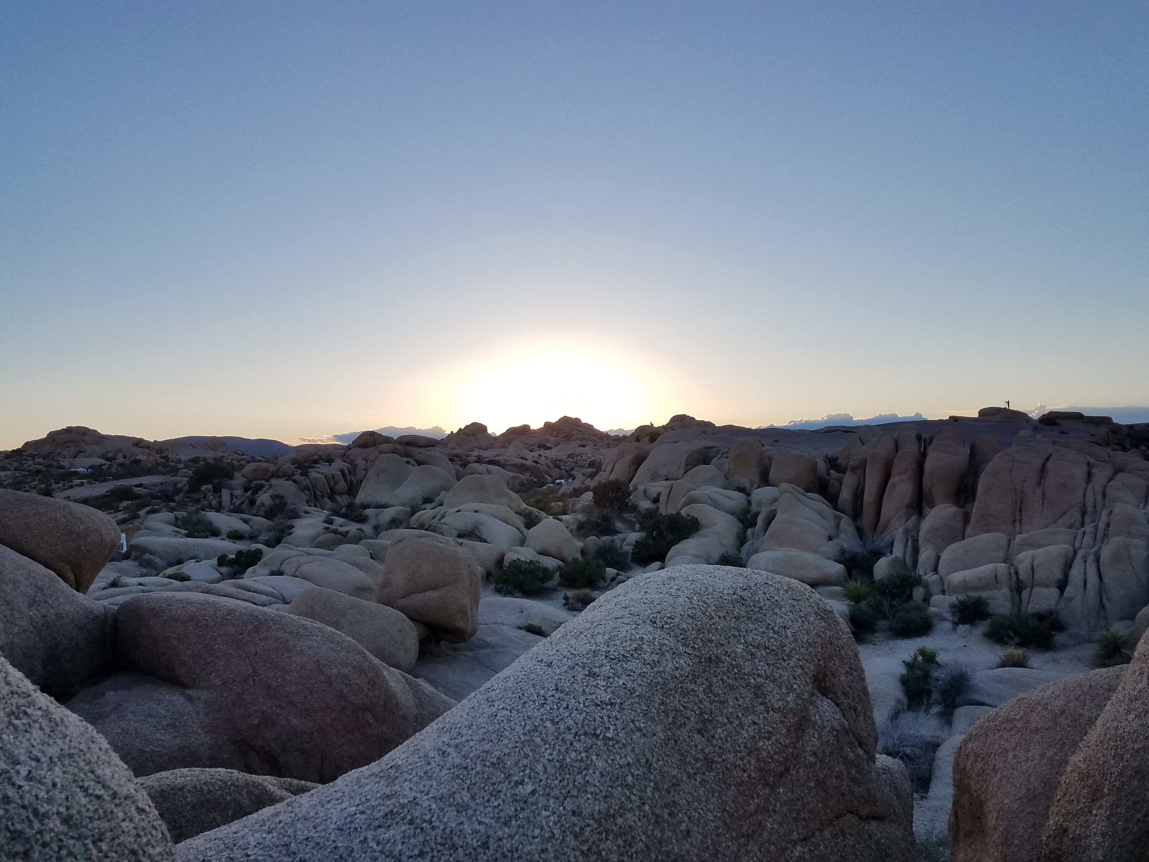
As a base for my own decent living over the next two nights, I set up shop at my tent in the Jumbo Rocks campground. Here, I notice my only great error of the trip: I’ve left my ground fly behind at the campground in Sequoia. Thankfully, I won’t need to worry about too much condensation on the ground affecting my tent here. Jumbo Rocks, meanwhile, is about as excellent as a campground of its size and style can be. Its namesake rocks separate all the campsites and make them seem much more isolated than they are, and some scraggly bushes offer additional privacy. People pop up on rocks here and there, once again answering the park’s invitation to explore and hop from boulder to boulder.

Some things one can’t escape in a car campground. Just after nightfall, the site across the way is, very gradually, occupied by three vehicles: first an SUV, then a camping van, and then a monstrous RV that is towing another camper. This can’t be legal, but after about 50 attempts and a forced relocation of the neighboring camper’s vehicle the RV’s driver manages to fit it into the parking spot. But, other than their headlamps occasionally brightening my quiet site, they turn out to be passable neighbors. Even though my evening meanders take me past a few sites throwing full-fledged parties, it still manages to be a fairly quiet place thanks to the maze of rocks.

20180502_191252

I make my own explorations of the rocks that evening, first with a half-mile walk over to Skull Rock and back, and then with a clamber up the boulders right behind my site. Joshua Tree’s second great claim to fame, its starry skies, slowly begins to emerge. The daytime clouds are gone now, and the heavens slowly open up. Jupiter is immediately visible in the west, and in the hours between sundown and moonrise, as brilliant a night sky as I’ve ever seen emerges. Even in the darkness, it seems crowded: whether due to proximity to Los Angeles or just something about this latitude, the skies are littered with satellites and airplanes. Ignore the flashy lights, I tell myself, and focus on the more permanent specks that complete their hundred light year journeys in my eyes.

It’s going to be a chilly night in the desert, but I leave my rain fly off: the stars are worth seeing for as long as possible. I cocoon myself in my sleeping bag and wrap myself in excess clothes for insulation, and fall asleep far more easily than I had the night before. I wake with a start sometime in the wee hours and am shocked by what I hear: silence. Pure, untouched silence in the night, not even a breath of wind. I shudder and wrap myself up tighter, but grin in spite of myself as I stare up at the waning gibbous moon.

The sun pours through my scraggly bush early the next morning. I slowly extract myself from my protective casing, then head straight out for a hike before the heat and sun can take their toll. My first destination is Ryan Mountain, one of the highest points in Joshua Tree at 5,457 feet. The trail is 1.5 miles of nonstop climb, though nothing technical, and it’s early enough that parts of the western slopes are still in shade. There isn’t a cloud in the sky, but the chill wind persists. I can get all of the sunburn without any of the sweat. I plow up Ryan Mountain, appreciate the view, and then push down, stopping only to chat with a poor Ohioan who is already struggling with this sudden discovery of elevation even though he’s only a quarter of the way up.

Next, I head to Keys View, a drive-up lookout over the Coachella Valley, which includes the town that hosts the music festival and the resort haven of Palm Springs. To the west is a gap in the mountains, and a signboard informs readers that this pass over to Los Angeles is the reason why this valley is so hazy. I can make out the Salton Sea despite the smog, along with a couple of the highest peaks in southern California, including Mount San Gorgonio, which still bears some snow. On the way back down I stop by a couple of the well-named rock climbing spots, including the Oyster Bar and the House of Horrors, to drink in the desert.

My second hike of the day leads toward a place named Pine City (not to be confused with the small town halfway between Minneapolis and Duluth). It’s off the beaten path at the end of a gravel road, and merits only a cursory mention in the park guide. I climb gradually through open desert, the path marked only by rows of rocks on either side, with colorful cacti brightening the way. Eventually, it descends into a wash of sorts populated by a bunch of pinyon pines, by far the largest living thing out here. Further on, a ridge provides a window down to a valley to the north, and while the trail isn’t maintained past this point, I pick my way down a slope and rock-hop for some better views. I come back a bit and settle under a pinyon to guzzle some water and read a chapter of Abbey, who rhapsodizes about the nostalgia and hunger for that which is beyond our reach that lies in the desert. Could there be a better settling? Content, I hike back to my vehicle, meandering to see a few more trees and rocks along the way. I don’t see another soul.

It’s after noon now, and while it’s still a temperate desert day at 73 degrees, it is cloudless, and my skin is starting to bake. I head in to Twentynine Palms, another of the oasis towns just north of the park; down here in the lowlands, the thermometer hits 88. I check out the palm trees around the Oasis of Mara, read the signage on Joshua Tree godmother Minerva Hamilton Hoyt (“The Apostle of the Cacti”), and use this oasis of cell service to inform a few people that I haven’t fallen off some boulder somewhere. My return into the park is disrupted by that scourge of any summer road tripper, the construction crew flagging traffic down to a single lane. Back at my campsite, I find a note from a ranger scolding me for hanging my camping dish towels from a bush to dry. This seems petty, but above all seems sad that rangers are compelled to make daily rounds with form letters to chastise people for their sins. Are we really that bad? I settle under a juniper next to my site for more Abbey. His misanthrope is normally a bit of a turn-off for me, but after a day in his wilderness, it seems more understandable.

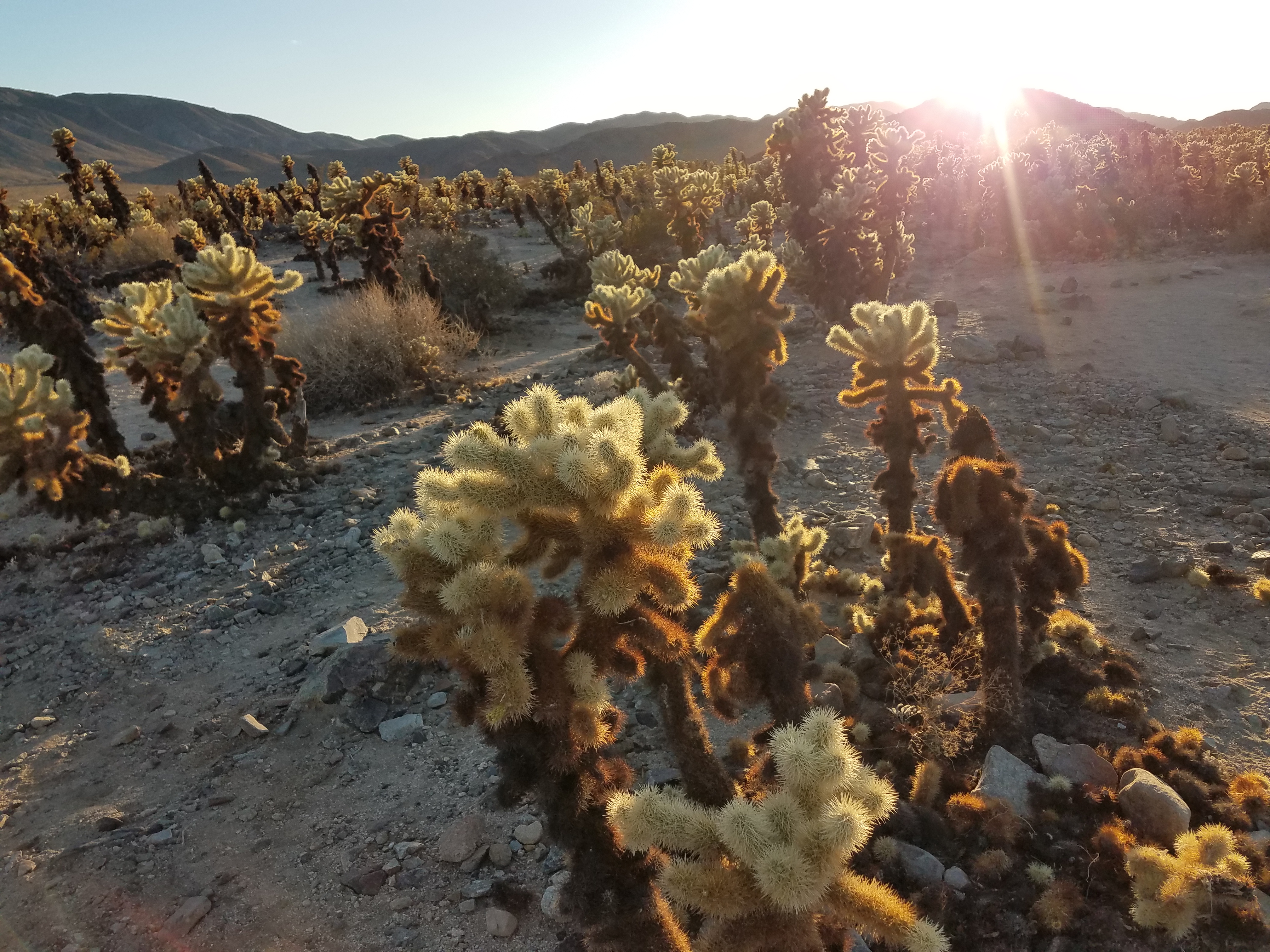
After a quick dinner, I head down to the Cholla Cactus Garden, which sits in the transition zone between the high desert of the Mojave and the more barren lowland Colorado Desert. The chollas live up to their reputation as they are set aglow by the setting sun. I make a couple of circuits of the quarter-mile loop, once in each direction: one of the greatest hiking mistakes is not looking back along the way one has come. I wait until driving back to the campground won’t put the sun directly in my eyes, and am rewarded along the way by seeing three coyotes in less than ten minutes. Back in camp, the giant RV people across the way have been replaced by a young pot-smoking couple who have little Christmas lights up in their tent and a hip-hop soundtrack as a backdrop to their conversation. With enough wine, I get it to a point where it fits my mood, and I write in contentment before another night of cold and stars.

20180503_185001

This trip features a lot of time to myself, and I’m a rare loner in these campgrounds. I’m glad I’ve traveled this way, as it’s given me no shortage of time to think and clear my mind. I’ve become a proficient long-distance driver, and it’s a very Me way to travel, just pushing on to the next destination, an ambitious itinerary executed as well as I can realistically manage. I’m writing plenty, and going through plenty of good books. Boxes checked, left and right. But at the same time, I’m not exactly pining for another such trip.

Some of my concern is practical. Everything just takes longer when one travels alone, and times when I thought I’d be free to read or write turn into food prep or dishes or setup and takedown, even for someone who has efficient systems for all these tasks. A simple division of labor is one of the best arguments against atomized living that I’ve ever encountered. (I’m aware this is an ironic point coming from a single person who lives alone, but that doesn’t mean I think this is an admirable state of affairs, or that it is the endgame.) But for all my enjoyment of Abbey in the wilderness, I find my wandering to an old favorite essay, one by Jonathan Franzen (whose misanthrope can put Abbey’s to shame) on his trip to one of the Pacific’s most isolated islands in which he concludes that radical solitude is no way to live.

Perhaps I’m too much of a lover of a communal life. Maybe that’s why, for all my writing pretentions, I’ll remain an intermittent blogger, and never a noted conservationist writer, or a Great American Novelist. But for now, it’s a price I’m willing to pay.

West Coast Road Trip Wrap

Here are a few stray thoughts on my road trip before it recedes too far into the rear view mirror and return to blogging about other things. All of the blog entries from the trip are here:

Intro  | Minneapolis to Salt Lake | Salt Lake to San Francisco | San Francisco to Vancouver | Vancouver to Seattle | Seattle to Minneapolis

First off, road trips are an excellent way to see the country. They allow for considerable flexibility, and put one in control of one’s agenda. Want to swing by Tahoe, or stop at a convenient overlook? Well, you can. With two drivers, 10-hour days are very manageable. The U.S. has an interstate highway system that we all take for granted now, but makes long-distance travel by road remarkably easy.

It’s not always speedy; the West in particular is remarkably big, and it can take entire days to cross a single state. Nor are these spaces between large cities always thrilling. But if you’re into catching some details or interacting with people who live outside the U.S.’s urban bubbles, there’s a lot to be said for crossing these spaces. It gives a more adequate sense of scale, and how disconnected the entire nation is, and how hard it is to slap an all-encompassing narrative on all of these distinctive little corners.

Here are some recommendations for other would-be road trippers:

When you can, stay with people you know. Staying with locals with a strong knowledge of a place makes any trip more enjoyable. They’ll know which common tourist stops are worth visiting, and which ones to avoid. They’ll know the gems off the beaten track, know food and drink, and are probably savvier than Siri when it comes to getting around. Our time in San Francisco and Portland was much richer for that, and staying with people who both reflect the ethos of their cities and filter it through some Midwestern sensibilities made them invaluable guides.

If you don’t know people in a place, consider camping. Nothing against Airbnb, which served us well when we used it; hostels are also fine, particularly for the younger set looking to make some friends along the way. But camping is cheap, easy, doesn’t intrude on anyone, and far more likely to be peaceful. Obviously, there are different ranges of camping comfort out there . But that night in the Black Hills, despite being at a fairly busy campground, was one of the nicest of the trip, and had us wondering if we should perhaps camp more on the return leg. Unfortunately, our tent’s disappearance put that all to rest.

Don’t leave things in your car that signal it as a target. We thought we hadn’t left anything of great value in the back seat of the car: a food bag, a sweatshirt and a t-shirt, a couple of pillows. But there was just enough stuff to encourage someone to break in when we were in San Francisco. After they smashed the window, our thief got into the trunk and found the gold mine: the tent, the sleeping bags, the beer, the books on disc. We were a bit paranoid after that, and basically cleared out the inside of the car every night from then on. But in general, less clutter makes a car less inviting. Finally, be sure to valet lock the trunk so that people can’t get at it even if they do break into the car.

Tune up the car before you go. The last thing you want is a breakdown somewhere in the middle of Nevada. Make sure it’s in top condition before you head out.

Choose travel partners wisely. When you’re trapped in a car for ten hours a day with a person, you get to know them pretty well. It’s long, you get tired, and everyone’s neuroses will inevitably come out. Be prepared for that. It’s best to be up front about arrangements: rotate gas purchases, make a spreadsheet to track everything else. A little space from time to time is probably a good thing, even among close friends.

Don’t waste the chances when they come. This gets harder and harder with age. Do it, and do it now.

Finally, some superlatives from the entire trip:

Favorite city to visit: San Francisco.

Most likely to move to: Seattle. Vancouver would probably win if it weren’t in a different country.

Best meal: Nopalito, San Francisco

Best dose of grease: Lardo’s, Portland

Best bar atmosphere: Bimbo’s Cantina, Seattle

Honorable mention: The Mangy Moose, Hill City SD; Alibi Room, Vancouver

Best picnic site: Watchman Overlook, Crater Lake National Park

Honorable mention: Lake Tahoe; Independence Rock, Wyoming

Best beer: Russian River…not for any one particular beer, but the entire range available

Best wine: Ridge Geyserville

Most beautiful natural site: Deception Pass on Whidbey Island, Washington

Honorable mentions: Needles Highway, South Dakota; Painted Canyon, North Dakota; the color of Crater Lake

Most beautiful view of a city: San Francisco from the Marin Headlands

Honorable mentions: North Vancouver toward its downtown; just about anywhere, Seattle

Most pleasant surprise: CorgiCon 2016, San Francisco

Least pleasant surprise: Car break-in and theft, San Francisco

Finest moment: Swerving to avoid unsuspecting baby birds in the middle of the road, Montana

Forgettable moment: Closing an Uber door on Andrew’s head, Seattle

Most fun drives: I-80 descents into Salt Lake City and out of the Sierras; Lake Boulevard around Lake Tahoe; I-90 in central Montana; any road in California wine country

Best college campuses: University of San Francisco, University of British Columbia

Best podcast listened to: “Invisibilia” on how turning a bunch of oil rig workers into saps made them better workers

Most boring state to drive through: Nevada (Wyoming and the Dakotas both have some stretches of distinctive natural features)

Best drivers: Utah

Worst drivers: Washington

Best dose of Americana: South Dakota

Most likely to revisit soon: Theodore Roosevelt National Park

Next road trip: American Southwest, anyone?