This post is the first in a series of two on my recent trip to California.
As far as hiking trails go, the Lost Coast Trail doesn’t appear overly challenging. Totaling just 24.5 miles over four days, this is a placid pace by my standards, and there’s little in the way of elevation to contend with. It’s a hike along a beach wedged between the Pacific and the King Range in Humboldt County, the longest undeveloped stretch of Pacific coastline in the lower 48. Its greatest challenges are three zones totaling just over eight miles in length that are impassable at high tide, so hikers must bring tide tables and pick and choose their start and stop times. Informal campsites sit at the mouths of creeks that feed into the ocean at regular intervals along the trail. The Lost Coast isn’t totally lost, as my party encounters plenty of fellow trekkers, but all but a handful follow favorable breezes from north to south, and long stretches are just my five companions and I working our way through the fog on a narrow band of land separating jagged peaks and unfathomable depths.
Hiking the Lost Coast is unlike a jaunt on a more traditional trail. One can’t just stare at one’s feet, or gaze off at the mountains or the sea for too long. Lost Coast hikers have to pick their lines, much like Alpine skiers, finding the best route over this avenue of choppy rocks and boulders and sand and incoming waves. Back sides of ridges, when wide enough, tend to be most stable, as do depressions behind them where the sand stays wet and thus more firm. Without obstacles, wet sand close to the surf is the best highway forward, though it bears the not insignificant risk of wet feet or frantic rushes inward at every rogue wave. Rarely is it a technically demanding trail, but it is often a slog over terrain that shifts beneath every footstep.

For this trip, I’m a new addition to a group that has, plus or minus a couple of members, taken a backpacking trip once a year for the past decade. The organizer is my uncle Bob, and our number includes my cousin Rob, Bob’s sister Betsy, her friend Amy, and family friend Ed, a divergent group of personalities with homes ranging from Louisville to San Francisco, united by a fondness for meandering down paths in the wilderness. Uncle Bob promises me an adventure, and after an hour of wrangling over food choices at a San Francisco, their two additional stops within twenty miles of a lunch stop in Santa Rosa, and a laborious gear distribution affair at a hotel in Garberville the night before our hike, I’m starting to doubt my wisdom in joining this trip. But they are entertaining company, and by the time we hit the trail, I’m reassured that I’m in the company of five committed adventurers.
We leave our cars at the south end and pick up a shuttle in Shelter Cove, a resort town that offers a fascinating mash-up of sprawling vacation homes and rural California country folk, a people forgotten in most conceptions of the state who wouldn’t be too far out of place in the rural Midwest. (Our shuttle driver, a Humboldt County lifer about my age named Connor, laments the annual Fourth of July homemade firework displays as “Armageddon” and a miserable undertaking for himself and his fellow members of the volunteer fire brigade.) After a two-hour drive through the mountains to take us 25 miles as the cormorant flies to the trailhead, we’re ready to set out.
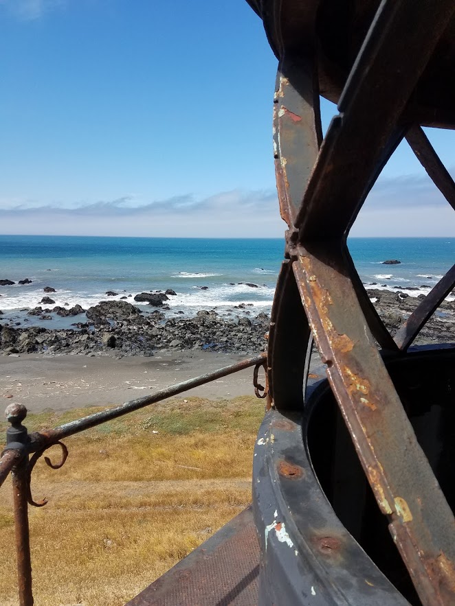
At first, the beach hiking is novel, and we make good time. A couple miles in we round Punta Gorda, one of the westernmost points in the continental United States, and come to the abandoned Punta Gorda lighthouse, a lonely outpost here along the coast that lit the way for lost fishing boats for a few decades. The structure is open, and a climb up a rusting spiral staircase takes one to a deck with excellent views and even stronger winds. Down below, a gaggle of sea lions flops about in the sand and in the tidal shallows, singing with characteristic inelegance. At Sea Lion Gulch the trail meanders inward before it slips down to the creek, where we cross it twice in quick succession, little hops along rocks to find a passable course past this gouge in the coastline, the sea lion grunts echoing in the background. These turns inward to solid ground are blessed relief, though I don’t like them to last for too long: we are here for the beach hike, after all.
Our first camp comes at Cooskie Creek, a 6.5-mile excursion from the starting point at the mouth of the Mattole River and midway through a four-mile stretch of trail impassable at high tide. We are all sunburned, the cool, perfect walking temperatures and early morning fog lulling us into a false sense of safety, but otherwise no worse for the wear. We take a site on the south bank of the creek, while a large party occupies the opposite bank. They are quiet and we rarely interact, though we do marvel at their ingenious game of bocce using rocks on the beach. The wind barrels in from the ocean, and tent setup requires up to four people and a lot of rocks just to keep things upright. At sundown, we climb a small promontory and gaze out on the Pacific, west to Japan and south to Antarctica, with no bodies of land in between. The sun doesn’t set cleanly but instead fades away into the marine layer out over the ocean, lost in the eternal fog.

The wind dies in the night. No wind, no sun, West Coast resident Rob tells us, and sure enough, we are ensconced in clouds and fog as we head out. A dead seal on the beach attracts a crowd of birds, and Amy compares the beachscape to the final scene from Planet of the Apes. The waves rise as we go, and a crossing at Randall Creek requires an ambitious leap. Past the creek I pick out a trail up on to a flat, and now we’re rewarded with an easy stroll along a ridge, past a stream crossing with an unexpected bamboo grove and another where the discovery of a snake in the trail holds up the party for a spell. The crossing at Oat Creek features a stable log amid a small grove of trees, and a group of younger women has stopped here for lunch.
We cross Kinsey Creek and a rock field to the mouth of Big Creek, which we edge over on a log. Rob and I like the look of the site, an open stretch aside a large wash where other campers have set up driftwood lean-tos and tables, but the rest of the party is ready to push on another two miles to Big Flat Creek. These two miles are among the most tiring slogs of the trip, endless rock fields that turn ankles and require constant leaps, but in time I veer off and pick a way up a sandy slope to a much smoother trail atop Big Flat. The rest of the party joins me, and before long it’s as if we’ve left the ocean behind and are strolling through a large meadow. A number of private landowning holdouts dot the entire trail, most no more than a windblown wooden shack, but the one on Big Flat is flat-out surreal, a retreat of sorts that hosts a large group doing tai chi down by the beach. This part of the Lost Coast feels far too found.
Just past the retreat center is Big Flat Creek, our destination for the night, but it proves the most complicated stream crossing of the trip. The creek is wide and rushing, and Ed and I venture upstream with no luck in search of an easy ford. Most of the party settles for a shaky-looking log crossing, while Amy and I jump it at the mouth, where these streams are usually at their narrowest. The campsite, situated beneath a grove of low trees, already has a crowd, but there are enough sandy tent pads for us to carve out our own space. Night comes quickly on this day, with little time to linger on the beach, though we do admire the deer in the clearing next to us, and after dark a number of bats flit overhead. In the night, a chorus of coyotes wakes us all, the pack leaders howling away while the yips of their smaller brethren surround them.
I don’t sleep particularly well on Big Flat, but our long hike yesterday cues us up for a tame day of just 3.3 miles to our next site on Buck Creek. I sip some tea over breakfast and take a dump in a sandy hole in the ground, and we join a large procession of hikers out from Big Flat and down the coast. The fog is thickest on this morning, and it cakes the beach and leaves what we can see of the fire-scarred hills above us looming. After a placid stroll along the flat, it narrows down to nothing, and a rock slide diverts us down a jagged slope to a narrow beach. Each step brings new conditions, most dramatically at the bottom of a large landslide, where giant trees come to rest on the beach. The crossing at Shipman Creek offers a nice running start for the long jump across, and we press on and pass a few of the groups we’ve been leapfrogging with over the course of the day.

Buck Creek comes as a surprise, and we quickly decide the campsite, which perches on a bank with direct views of both the sea and the cascading creek, will more than do. The fog lifts with surprising speed as we set up our tents, and we then discover the site’s great drawback: a healthy crop of poison oak on all sides that leaves Amy and Betsy frantically detoxing after they tossed some gear and staked out a line for their tent in the shrubbery. Lunch follows the cleansing session on rocks along the creek, though my phone’s camera renders me an uninspired photographer for the rest of the trip after it falls out of my pocket and its lens cracks on a rock. The shots feature some fascinating new filters, if nothing else.
With some gas left in the tank, Bob, Rob, and I set out to climb the Buck Creek Trail, which rises from the camp and heads straight up into the hills. Straight up is no exaggeration: there is no such thing as a flat or downward step for a mile-and-a-half long, 2,000-foot climb. Thankfully, the sun gives way to pine forest just above the site, and while we’re still stepping gingerly around the poison oak, we can drag upward at a manageable pace. Finally, near the top, we come to a couple of clean vistas down the coast toward our parked cars at Shelter Cove five and a half miles away, and after a relatively flat half-mile past a junction with a little-used ridgetop trail in the King Range backcountry, we turn around and abuse our joints for a few miles back down. We burst back out of the forest and have a clean view of the rushing creek, the sun-splashed waves on the ocean; Amy and Ed are down on the beach watching the tide come in, while Betsy naps on her air mattress in the open atop the highest-lofted tent pad, the tents collecting heat for the night in the sun below. It’s a paradisal scene, one that fully loses me in this wilderness and makes me wish we could set up camp here for a week.
Our legs burning from the hike, Rob and I watch the tide roll in, larger and larger waves slowly creeping over the rock pile that cuts off Buck Creek from the ocean at low tide. Soon there will be no way in or out of this site along the coast trail, and we’ll have our site to ourselves tonight. After some poison oak preventative cleansing in the creek, I settle into the hammock along its banks to catch up on notes and zone out in bliss. I’m rousted for happy hour by an offer of Ed’s tequila, and as we sit along a log on the beach and gaze out at the sparkling waves, my mind goes back to an out-of-body sensation I had in a hammock in Puerto Escondido nine years ago, a simultaneous blend of exhaustion and tequila and revelation at the beauty around me. I idly wrote a story of two lovers at the end of an affair, at once alive to the possibility of utopia and aware it can never last.
We break out of our trance to eat before we lose all daylight. Our dinners, always collections of freeze-dried packets we pass around, is best on this night, and we polish off the bourbon and turn our attention toward the darkening sea. Three boats dot the horizon, one of which suddenly seems to be flickering, as if alight; we later learn that it’s likely a fishing boat looking to lure in its prey. The half-moon lights up night well enough to cast shadows, and the marine layer stays just low enough to allow for superb star-watching. First Jupiter and the dippers, then Scorpius and Cygnus and Hercules, and Saturn for a hot second before the fog consumes it. I’m reluctant to turn in, yet I enjoy my best ever night of sleep in a tent.

The morning is wet, the marine layer dousing my tent fly, but the sun comes out quickly and keeps up warm for the last 5.5 miles up the beach. The choppy rocks continue for the first half of the hike, but after that it settles into a plodding but predictable march up the aptly named Black Sands Beach. I set my course along the shoreline, running in when the higher waves come and making sure to drink in the slopes to my left and the endless crashing waves to my right. The steepest climb on the hike comes up a road to the parking lot, where we collect ourselves ahead of food truck burritos and a beer at a Shelter Cove bar populated by grizzled local women. We are found again, headed back for a stop in wine country and the glitz of San Francisco to round out our adventures.
The trail has a particular allure for someone drawn to the notion of isolated inspiration, the egotist who never needed anyone to tell him that he could do great things if he put his mind to it. Thankfully, wilderness also has a habit of humbling these chasers as well. A year after an epic but largely solitary trek across this state, the jumble of people on this one enlivened it. It provided new short story inspiration, and a meander through a book on Wallace Stegner and Edward Abbey, two very different champions of the West who, unlike some of the San Francisco cosmopolitans I brush up against upon my return to the city, understood a sense of place. “I may not know who I am but I know where I am from,” wrote Stegner, words that forever reassure a wanderer in search of grounding. On the Lost Coast Trail, I’ve found it yet again.

thank you Karl. This was inspiring. I can picture what you saw in my mind.