This post is the second of two on my 2021 western road trip. Part 1 is here.
For the fifth time in six years, I am headed west in summer, and for the fourth time, this venture comes by car. In part, it’s a matter of convenience: travel from Duluth by air would still take a lot of time, and it allows me to ferry objects like bear spray and fuel canisters that my plane-bound fellow hikers cannot. But I have also fallen rather deeply for the roads across the high prairie, for the open skies and the baking sun, for the sudden anonymity found in rest areas and scattered parks across badlands and foothills of great peaks. It is my own little nod to the myth of the West, a pursuit of the frontier in a world that now disdains them. To drink its possibility, if only for a little while, intoxicates.
I orchestrate a work trip across central Minnesota the day before my scheduled departure, and upon my release from those obligations, my trip starts in a traversal of mind-numbing St. Cloud and up Interstate 94. A malign haze has hovered over Duluth during this summer of fire, and upon first viewing, the big skies of the West are no different, shrunk down to size by the same dark cloud. The view from the 12th floor of the Jasper Hotel in Fargo, which should reach off to eternity, sometimes dies as close as one block away.
Still, thanks to some recommendations from a native son, Fargo proves it’s much more than a stereotype from a movie in which it didn’t really figure. Its downtown is booming, bustling, and filled with both newly developed and tastefully rehabbed old storefronts. The Jasper is chic, and the beers at Drekker Brewery, a former train maintenance facility, are top-notch. Having crossed the Red River into a red state, concerns about Covid have seemingly ceased to exist. My whole stay there feels like a throwback to sometime in my mid-20s, free to enjoy certain novelties as if they were new again, if perhaps shrouded in an uncertain fog.
Beyond those few square blocks of downtown, though, Fargo’s sprawl is dismal, and the smoke has made eastern North Dakota, one of the most boring landscapes on earth, even more boring. I drive on without stopping. For my listening pleasure, it’s some Plato on the prairie, a world away from the soybean fields I pass. But as usual, the rising hills beyond Bismarck signal the start of something new, and I pause to pay my respects to Salem Sue, the giant cow gateway to the West.
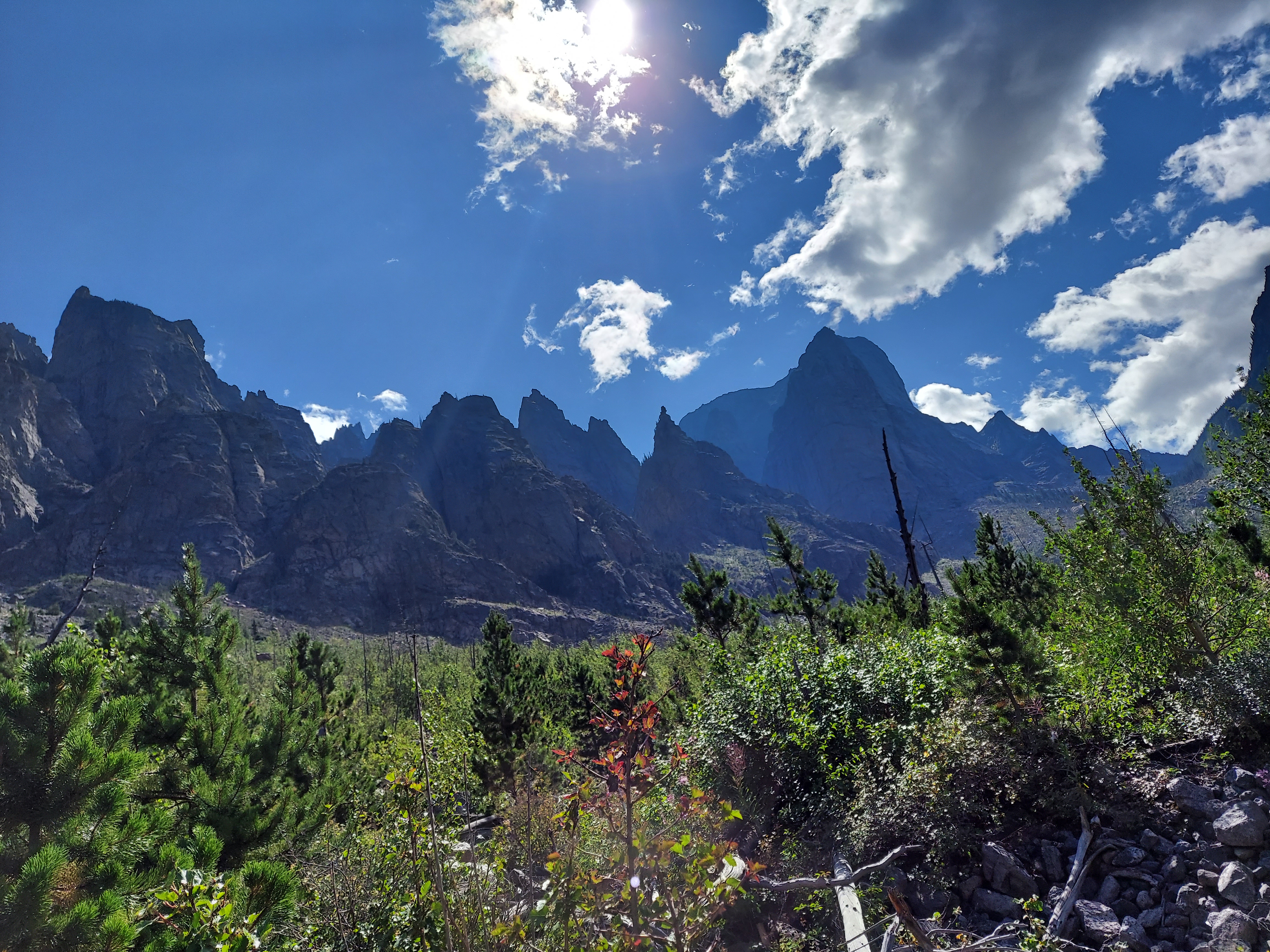
Last year, when I visited Theodore Roosevelt National Park, it felt like I had acquired a private 70,000-acre retreat. Across a two-night backcountry stay I saw only scattered visitors and three bison. This time, on a three-hour visit in which I don’t go over a quarter mile from the road, the cars crowd in, and the bison number in the hundreds. The combination of animals and humans makes for slow going, and the drought-plagued Little Missouri River is a sorry shell of its usual self, but my ventures somewhat off the road, both down Wind Canyon and out to a promontory off the Boicourt Trail, remind me why I fell for this landscape so completely a year ago. Its tumbled badlands still offer up that perfect mix of forbidding austerity and teeming life, an apt summation of the West and all that it has meant. I’ll be back again.
On this night, however, I push on another hour to Makoshika State Park, just over the Montana border and through the shabby town of Glendive. My campsite up Cains Coulee is a bit drier than Theodore Roosevelt and lacking in bison, but the things that make that park great apply here, too. I feel a bit silly as the lone tent camper surrounded by four RVs on my little circle of the campground, but overcome a tent malfunction to enjoy my dinner and loop up the bank of the coulee past the vertebrae of a hadrosaur for a few sips of mezcal from an overlook above my camp. The sun fades away behind a ridge and into the haze as my legs dangle off a bench made ever higher by the steady erosion of the badland dirt. A thunderstorm strikes not long after I return to camp, and I make do with a writing session in the car, the stressors slipping away as I fall deeper into this trip.

Evenings in car campgrounds in the West are inevitably spent among a unique subset of humans known as RV people. RV people are couples with an average age in their 60s, probably own a dog, and usually come from rural or semi-rural areas of non-coastal states. They are unfailingly nice and always make small talk, usually expressing something on a spectrum between admiration and concern for the choices of us tent people. Their lifestyle does have a certain allure. They have the comforts of home while living itinerant lives, a convenience that allows my three neighbors at Makoshika to just pull back the blocks holding their tires in places and roll off in the morning while I putter about stuffing various fabric objects back into sacks. On the other hand, my time among them involves being lulled to sleep by the dulcet drone of generators, their beds look rather sucky for anyone over six feet tall, and something always seems to be breaking in those big rigs. RV drivers also run the risk of being that big vehicle that clogs the ascents of mountain passes or piddle along at 18 miles per hour on their way out of Theodore Roosevelt, both prospects that mortify me at this stage of life. We’ll revisit these biases in a few decades and see if they still hold.
I spend my morning hiking Makoshika. The first stop is the Cap Rock trail, where I go in search of a natural bridge but see it only from the top and from some distance, as a family and I are twice thwarted by sloppy slides down the infamous, sticky mud of the northern badlands. Enough of this: I drive to the end of the road in the park, a horse trail that rides along a high ridge and feeds out to an overlook named Artist’s Point. The vistas along the way match those in most any national park, the baroque twists of this furtive land weaving out in every direction. There is a campsite here, tucked in a pine grove atop the cliff, and even with no convenient water, I file this one away for some future venture.
The high plains keep me alert as I drive west toward Billings, up and down the washes and along the Yellowstone River through towns bearing names of figures from the Plains Wars, some of whom appear in my audiobook choice that carries me through the rest of the trip, The Heartbeat of Wounded Knee. Its tone is a necessary corrective to the common lament about the Native American experience often served up in learned circles, and one I was drinking in fully on my trip through here last year. Yes, it is a sad tale of many deaths and betrayals and declines, but it is also one of perseverance, of continued existence even in the face of improbable odds. The message from its Ojibwe author, David Treuer, is, well, truer and more heartening than the easy cynicism of privilege-checking progressive thought.
My hiking companions on this trip are forced to come from Denver, the nearest place they could guarantee a car rental, and Uncle Bob calls to say they are three to four hours behind my pace. I take a detour to Pompeys Pillar National Monument, a promontory above the banks of the Yellowstone where one William Clark, split from Meriwether Lewis to explore this river on his return from Oregon, graffitied his name on the rock. A jog up the stairs to the top of the rock wakes me up, and a stroll through the cottonwoods along the riverbank has me feeling fresh. This pleasure fades some in Billings, whose dust- and smoke-choked strips I negotiate to collect some bear spray for our party. I worry the West is fully shrouded in wildfire, but an hour later, in Red Lodge, I see the bluest sky I’ve seen in weeks.
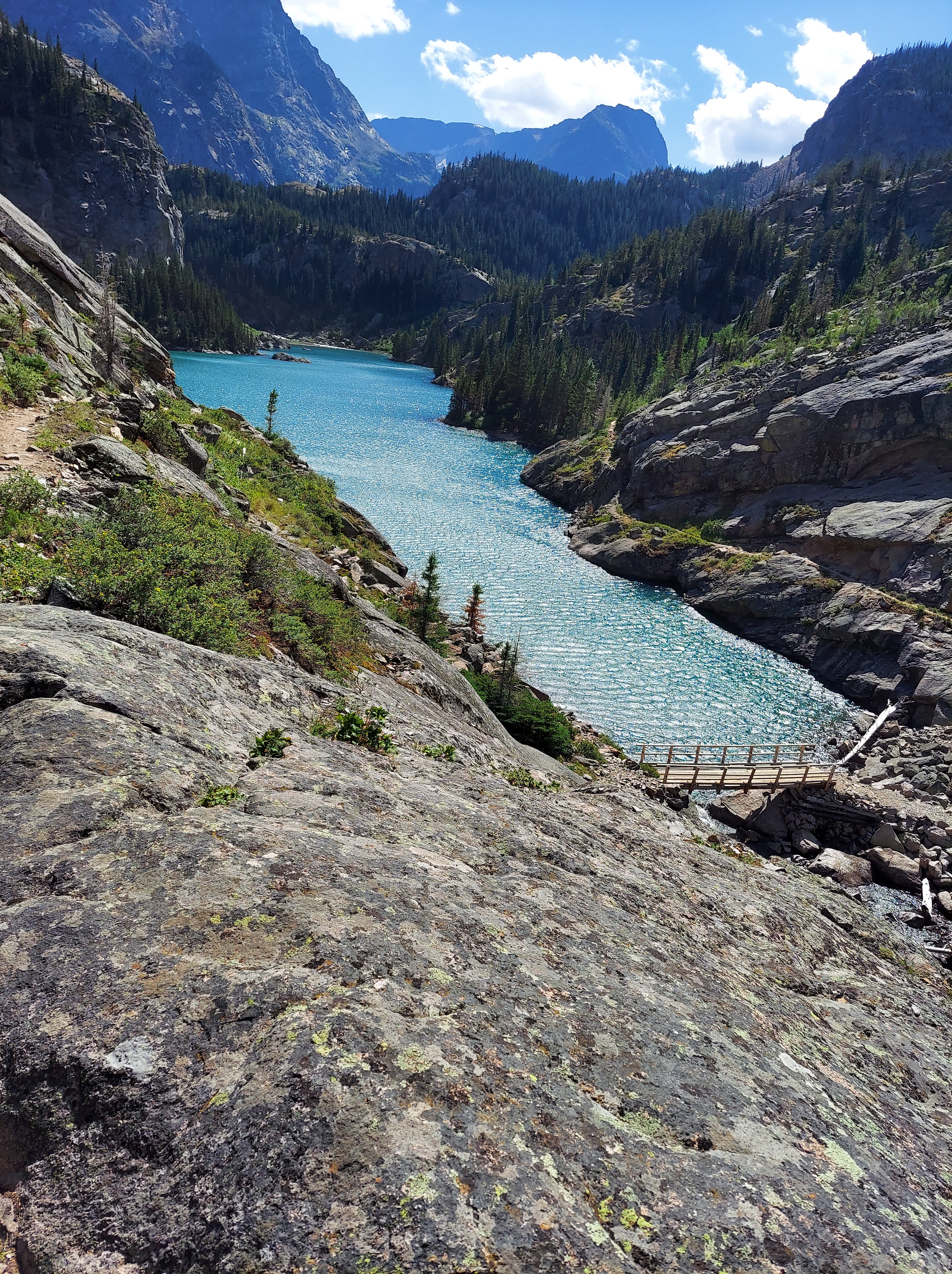
Red Lodge is a resort town, which means that, unlike the dismal highway strips I’ve traversed over the past two days, it has actual charm. Boutiques and restaurants line Broadway through its center, and its occupants range from wealthy tourists to hordes of motorcyclists to ski bums scraping along through the offseason. Bucolic scenes in the West, however, come at a price: $350,000, namely, for in-town, bland, out-of-date homes. Red Lodge also suffers from the same Covid Era crisis of rural escapes everywhere: lacking workers, many of its eateries close early, and the milling throngs wait in lines for the few places that are open. As with my fellow hikers’ journey from Denver, nothing is as easy as it used to be.
Our sojourn in Red Lodge provides us with another, less savory taste of Western life: an encounter with small-town police, who prove noxious busybodies as they harass one member of our crew the night before we begin our hike. Upon our return to Red Lodge later in the week, we make a joking show of checking every light on my car, and I put it in cruise control at 25 down Broadway. It may not have been excessive: as we leave dinner at a restaurant, we see the police fly off a side street and nail someone else. Gotta hit that quota, I suppose.
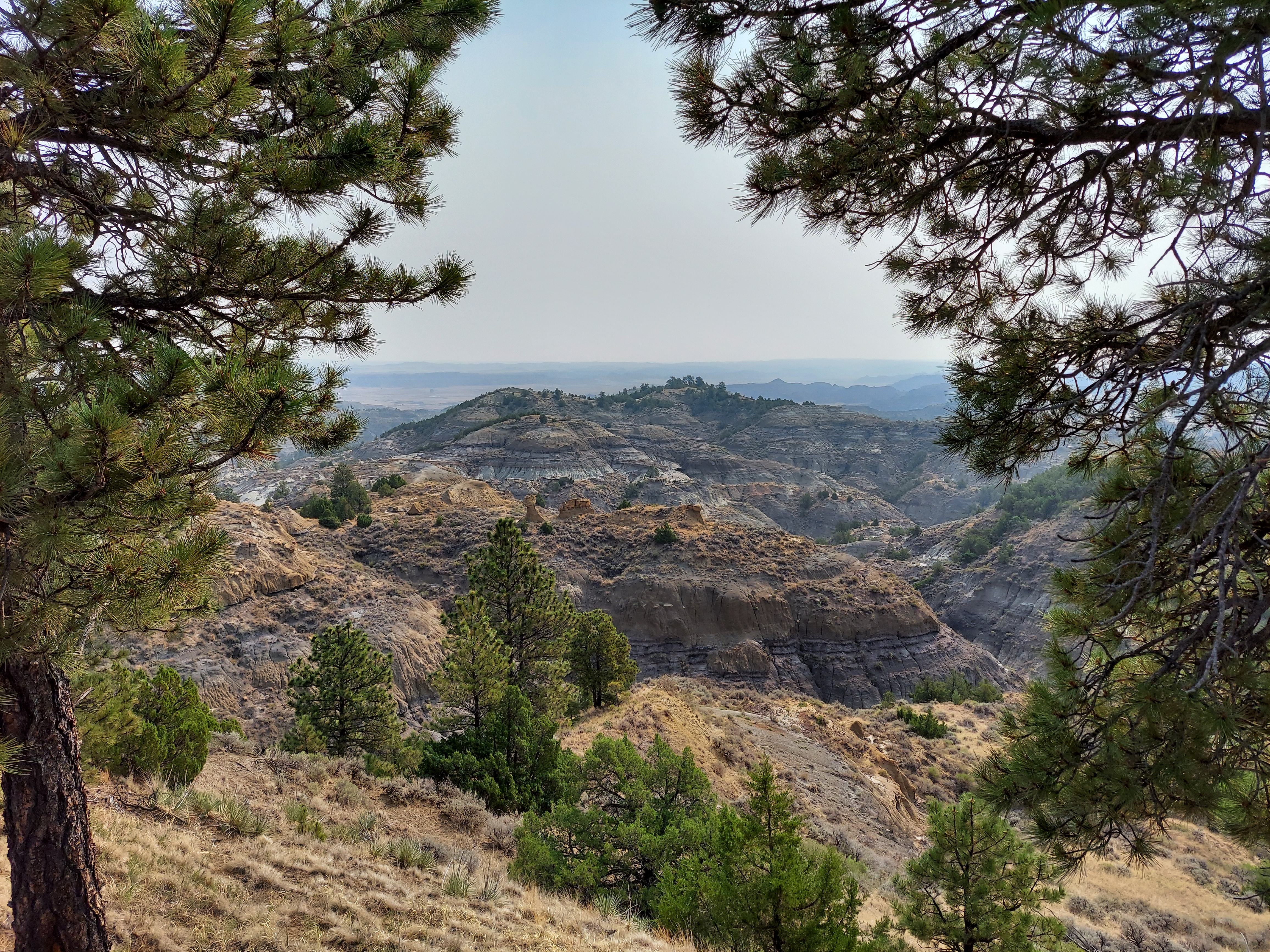
In search of some variety, I choose a longer road home: instead of plowing straight back east along I-94, I’ll swing follow a more southerly route to knock off a few new scenic sights. It doesn’t quite go to plan. Due to fires, I am denied a two-lane side trip across the Crow and Northern Cheyenne reservations on US 212 and forced to swing south on I-90 through Sheridan, Wyoming. Still, the Big Horn Mountains above Sheridan enliven the raw high plains, and the Wyoming wastes encourage a certain awe. I leave the freeway to stop at Devils Tower and circle the great butte on foot, stretching my legs amid 95-degree heat and hawks on updrafts and Native American prayer cloths and the crush of tourists from around the country. The Black Hills are swamped with motorcyclists in town for Sturgis, joy-riding here and there and everywhere. I have dinner on the Wall Drug strip in Wall, South Dakota, which is an experience if nothing else, and from there make my way south into Badlands National Park.

I arrive at Badlands near sunset. Ethereal beams from the sun filter through the clouds and bring a grey-pink light to the craggy slopes. Looming thunderheads light up in the sun’s presence, and as I wind my way along the park’s highway, the sun turns to blood red as it peeks between clouds. A prairie wind flits across the whole landscape, and here and there travelers have stopped atop the craggy landscape to sit and drink it in. I am loath to rush my way down the road, but nightfall is quickly shrouding the slopes in darkness, and for my trouble the rain begins just as I park at my very exposed site in the car campground. I deal with bathroom tasks and wait it out beneath the picnic shelter, watching the great thunderheads roll through before I set up camp by headlamp. I nod off as the day cools into a bearable temperature, content with a final night in a tent.
There is nothing to say about the rest of the drive; the road from the Badlands to Mankato, Minnesota, is deathly dull, before the banks of a low-water Minnesota River provide some intrigue for the final push into Minneapolis. This part is just the down-payment before cashing in on the rest, the West in all its stark beauty and forlorn silence and the crowds that come to seek it. The open road beckons, and I know I’ll answer its call again.