West Coast Road Trip Wrap

Here are a few stray thoughts on my road trip before it recedes too far into the rear view mirror and return to blogging about other things. All of the blog entries from the trip are here:

Intro  | Minneapolis to Salt Lake | Salt Lake to San Francisco | San Francisco to Vancouver | Vancouver to Seattle | Seattle to Minneapolis

First off, road trips are an excellent way to see the country. They allow for considerable flexibility, and put one in control of one’s agenda. Want to swing by Tahoe, or stop at a convenient overlook? Well, you can. With two drivers, 10-hour days are very manageable. The U.S. has an interstate highway system that we all take for granted now, but makes long-distance travel by road remarkably easy.

It’s not always speedy; the West in particular is remarkably big, and it can take entire days to cross a single state. Nor are these spaces between large cities always thrilling. But if you’re into catching some details or interacting with people who live outside the U.S.’s urban bubbles, there’s a lot to be said for crossing these spaces. It gives a more adequate sense of scale, and how disconnected the entire nation is, and how hard it is to slap an all-encompassing narrative on all of these distinctive little corners.

Here are some recommendations for other would-be road trippers:

When you can, stay with people you know. Staying with locals with a strong knowledge of a place makes any trip more enjoyable. They’ll know which common tourist stops are worth visiting, and which ones to avoid. They’ll know the gems off the beaten track, know food and drink, and are probably savvier than Siri when it comes to getting around. Our time in San Francisco and Portland was much richer for that, and staying with people who both reflect the ethos of their cities and filter it through some Midwestern sensibilities made them invaluable guides.

If you don’t know people in a place, consider camping. Nothing against Airbnb, which served us well when we used it; hostels are also fine, particularly for the younger set looking to make some friends along the way. But camping is cheap, easy, doesn’t intrude on anyone, and far more likely to be peaceful. Obviously, there are different ranges of camping comfort out there . But that night in the Black Hills, despite being at a fairly busy campground, was one of the nicest of the trip, and had us wondering if we should perhaps camp more on the return leg. Unfortunately, our tent’s disappearance put that all to rest.

Don’t leave things in your car that signal it as a target. We thought we hadn’t left anything of great value in the back seat of the car: a food bag, a sweatshirt and a t-shirt, a couple of pillows. But there was just enough stuff to encourage someone to break in when we were in San Francisco. After they smashed the window, our thief got into the trunk and found the gold mine: the tent, the sleeping bags, the beer, the books on disc. We were a bit paranoid after that, and basically cleared out the inside of the car every night from then on. But in general, less clutter makes a car less inviting. Finally, be sure to valet lock the trunk so that people can’t get at it even if they do break into the car.

Tune up the car before you go. The last thing you want is a breakdown somewhere in the middle of Nevada. Make sure it’s in top condition before you head out.

Choose travel partners wisely. When you’re trapped in a car for ten hours a day with a person, you get to know them pretty well. It’s long, you get tired, and everyone’s neuroses will inevitably come out. Be prepared for that. It’s best to be up front about arrangements: rotate gas purchases, make a spreadsheet to track everything else. A little space from time to time is probably a good thing, even among close friends.

Don’t waste the chances when they come. This gets harder and harder with age. Do it, and do it now.

Finally, some superlatives from the entire trip:

Favorite city to visit: San Francisco.

Most likely to move to: Seattle. Vancouver would probably win if it weren’t in a different country.

Best meal: Nopalito, San Francisco

Best dose of grease: Lardo’s, Portland

Best bar atmosphere: Bimbo’s Cantina, Seattle

Honorable mention: The Mangy Moose, Hill City SD; Alibi Room, Vancouver

Best picnic site: Watchman Overlook, Crater Lake National Park

Honorable mention: Lake Tahoe; Independence Rock, Wyoming

Best beer: Russian River…not for any one particular beer, but the entire range available

Best wine: Ridge Geyserville

Most beautiful natural site: Deception Pass on Whidbey Island, Washington

Honorable mentions: Needles Highway, South Dakota; Painted Canyon, North Dakota; the color of Crater Lake

Most beautiful view of a city: San Francisco from the Marin Headlands

Honorable mentions: North Vancouver toward its downtown; just about anywhere, Seattle

Most pleasant surprise: CorgiCon 2016, San Francisco

Least pleasant surprise: Car break-in and theft, San Francisco

Finest moment: Swerving to avoid unsuspecting baby birds in the middle of the road, Montana

Forgettable moment: Closing an Uber door on Andrew’s head, Seattle

Most fun drives: I-80 descents into Salt Lake City and out of the Sierras; Lake Boulevard around Lake Tahoe; I-90 in central Montana; any road in California wine country

Best college campuses: University of San Francisco, University of British Columbia

Best podcast listened to: “Invisibilia” on how turning a bunch of oil rig workers into saps made them better workers

Most boring state to drive through: Nevada (Wyoming and the Dakotas both have some stretches of distinctive natural features)

Best drivers: Utah

Worst drivers: Washington

Best dose of Americana: South Dakota

Most likely to revisit soon: Theodore Roosevelt National Park

Next road trip: American Southwest, anyone?

Advertisement

Road Trip Journal V: Seattle to Minneapolis

(Part IV)

Day Ten: Reasonable and Prudent

We wake early in Seattle the next morning. My friend goes out to grab a better breakfast, while I make do with mediocre hostel fare. We’re on the road shortly thereafter, headed east on I-90 over Lake Washington and through Bellvue before our final date with the Cascades. The mountains are shrouded in clouds today, with the sky a steely Seattle grey; the lowest of the peaks are lost in white, and some peek out above their airy halos from time to time. The passes here aren’t nearly as extreme as they are along I-80, and it’s a straightforward descent into central Washington, where the sun comes out and the temperatures rise.

Washington east of the Cascades just isn’t a place I’ve ever given much thought, and I’m surprised by how empty it is, its vacant highlands and amber waves of grain none too distant from Nevada or Wyoming. There are a few more towns, and the Columbia River gorge and crossing are a welcome and impressive break from the plains, but a mountain range leaves this area a world away from Seattle. This is the only place on the trip where we see a serious number of Trump signs along the highway, which says something considering the amount of deep red territory we’ve covered. Spokane passes quickly, and we leave Washington behind.

We make our lunch stop in Coeur d’Alene, Idaho, a lake resort town that we’re drawn to by pretty pictures we’ve seen before. Coeur d’Alene, it turns out, is no secret. Just thirty miles from Spokane, it’s packed on the Friday before Fourth of July weekend, with traffic backups and multitudes milling around its high-rise hotels. We eat a quick lunch along some cement steps leading down into the lake as boats buzz by beyond us and a seaplane comes in for a landing. But even if it’s not wilderness, it’s a welcome break. My friend takes a dip at the beach, while I wade in a little and admire the Idaho beach bums and the cartoon moose statuary.

2016-07-01 14.19.58

This is another day of extensive driving, and another one that leaves me impressed by the extent of the interstate highway system. It was a colossal infrastructure project, and while its story has its dark sides—ask anyone displaced by freeways punched through poorer parts of cities—it’s also a triumph of engineering and a marvel for interstate commerce. Even when clogged up by construction or congestion, it moves people with remarkable speed. Its construction radically remade small towns everywhere, as businesses shifted out of the core to little stops at exits. In Wallace, Idaho, we pass one of the towns that refused to bend to these changing tides. The residents of Wallace held out for years to resist the destruction of their historic downtown, and had it registered as a landmark in 1976. It took until 1991 for the government to complete a viaduct around it.

After some crawling traffic due to construction, we enter Montana, where speed limits are an afterthought. So much of one, in fact, that for a spell in the 1990s, speed limit signs along highways simply instructed drivers to go “reasonable and prudent” speeds. When the courts found this too vague for enforcement, the state settled on a poorly monitored 80 MPH limit. We rocket around bends and over mountain passes, though we’re far from the fastest car on the road. We pause in Missoula, where we continue our visits of college campuses and make a loop through the University of Montana.

2016-07-01 20.06.20

Through much of Montana, the road follows the Clark Fork, a river among the many features in this part of country named for Lewis or Clark. If there had been vacancies, we would have camped at the Missouri Headwaters State Park east of Butte, but with our tent long gone, it’s just as well that we’re now forced to plow on. We catch up with a storm near sunset, one that opens up in little spurts here and there in the hazy sky over the mountains, creating little sheets of rain with rainbows here and there along the route. Behind us, the sky is brilliant hue of pink mixed with sinking clouds. Another burst of energy to carry us through the final few miles.

2016-07-01 20.27.41

It’s dark by the time we arrive in Bozeman, where we’re the guinea pigs for a new Airbnb host. He delivers for us, and we grab a quick bite at a bar that caters to the Montana State crowd, one of the few places that still has an open kitchen. It’s too late to see much, and my friend is tired, so our list of Bozeman sights to see goes, regrettably, untouched. This may have been our most relentless day of driving, with few stops and no real thrilling destination at the end. The trip is definitely winding down, but we’re not close enough to the finish that we’ll miss any of it yet.

Day Eleven: Born to Run

We wake refreshed after a comfortable sleep in Bozeman, and Bruce Springsteen serenades us on the way east across Montana. The ranges of the western half of the state give way to craggy badlands and little ridges flecked with ranches. We catch our last glimpses of snow-capped peaks along the way, and pass just a bit too far north for a stop at Little Bighorn. I take over the driving somewhere east of Billings, after we’ve split north onto I-94. Today, I’m in a driving zone, just cruising along without distraction and drinking it all in. As is so often the case in the west, the freeway is in a valley along with a river (this time, the Yellowstone) and a train track, the rivers, roads, and rails all united in the easiest passage through the rough land all around.

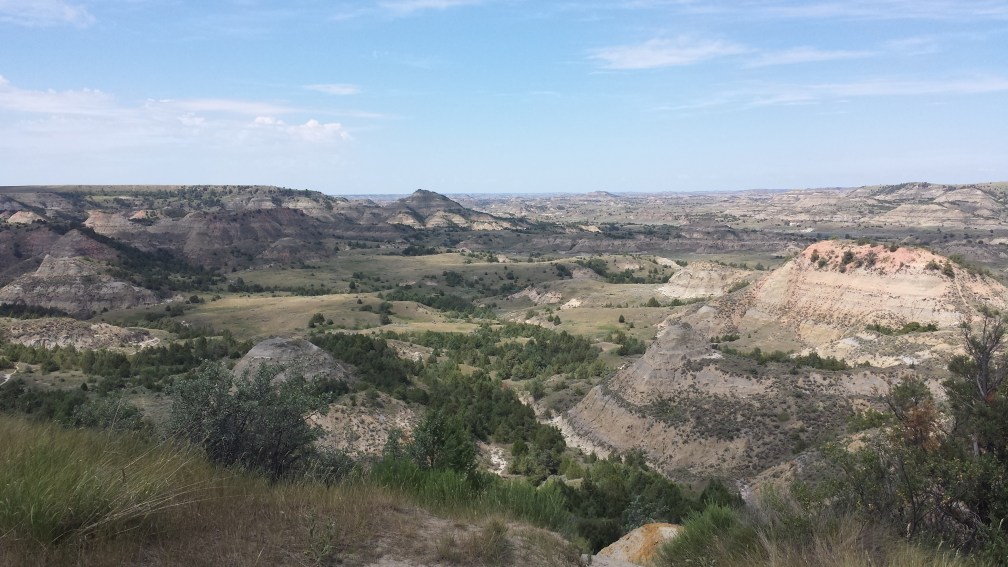
We cross the North Dakota border and stop for lunch at a rest area, where we’re greeted by the most North Dakotan of scenes: an endless green plain of farmland, stretching out as far as the eye can see. Things change up a little further along, though, as we come to Theodore Roosevelt National Park. It wasn’t in the cards for this trip, but it’s toward the top of the list of sites I want to see in the West. We make do by pulling over at the Painted Canyon overlook, where we’re treated to endless marches of painted badlands bubbling up over creeks and gulches. The spotty cloud cover adds to the contrasting colors, harsh and beautiful. Just a long day’s drive from Minneapolis, this park beckons me back in a way others haven’t. I feel that same pull that must have sucked in T.R. over a century ago.

2016-07-02 12.32.09

The badlands peter out shortly thereafter, and then it’s just North Dakota in all its glory. The state is particularly proud of its large manmade objects. We catch a glimpse of the bird-and-eye sculpture at the Enchanted Highway, pause for gas by the world’s largest sandhill crane, and see signs for the world’s largest buffalo. Our only real stop, however, is for the world’s largest Holstein cow, a beauty named Salem Sue, who stands proudly atop a hill outside tiny New Salem. Sue gazes out from what has to be one of the higher points in the state relative to its surroundings, and longs to graze on those endless green fields.

2016-07-02 14.00.02

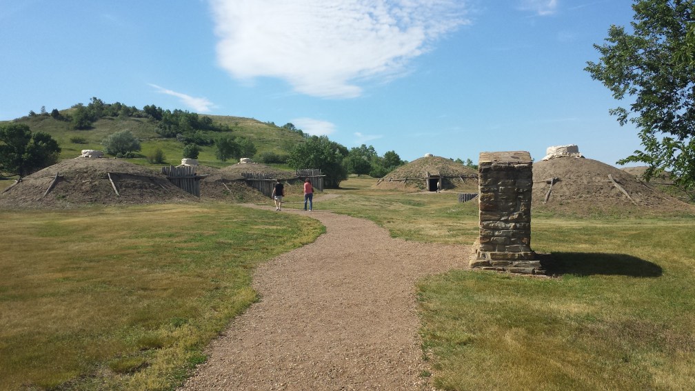
The original plan had been to spend our final night on the road at Fort Abraham Lincoln State Park, which is just south of Bismarck. Now that my tent is the property of some homeless San Franciscan, however, we’re forced to make contingency plans with my friend’s aunt outside of Fargo. Still, we have ourselves a pre-paid pass to Fort Lincoln, so we stop in for a brief visit. The visitor’s center tells us the tale of the Mandans, who once had a large village on the banks of the Missouri here. A few of their round earthen homes, deceptively large, have been rebuilt for us tourists. We wander down to the river, where a sandbar just out from the bank is overloaded with locals on boats enjoying the water. Opposite the wide Missouri is Bismarck, and the bizarre tower that passes for a state capital in North Dakota lords over it all. On our way out, we drive by the fort’s buildings, their unassuming architecture belying their historical significance. George Custer set out from here on his ill-fated final trek, off to the fields of Little Bighorn in southeast Montana. This outpost was the end of white civilization in the 1880s; now, it’s the end of the West for two travelers.

2016-07-02 15.00.17

The road east from Bismarck is a blur, and my friend’s aunt is ready to spoil us with dinner and drinks and political conversation late into the night. Her town, Casselton, is as sleepy as they come, and a single mother of two Harvard students is happy to pass the night a couple of Georgetown grads with steak and ice cream. It’s late, but I’m up writing anyway. I have a lot left to recount, and the final thoughts for tomorrow are already writing themselves.

Day Twelve: Return to Lake Wobegon

Throughout my childhood, Garrison Keillor’s A Prairie Home Companion was required listening on Saturday nights. We weren’t a churchgoing family, so the News from Lake Wobegon was the closest I got to a weekly sermon. We’d begin dinner sometime around the start of the show’s second hour, and I always sat and listened, even if dinner had ended. I haven’t listened regularly since I left home, and I won’t pretend to enjoy his singing or his seeming exhaustion by the end. But this weekend marks Keillor’s final show, so it’s only fitting that we listen to his final episode as we drive back into Minnesota.

The last morning of our road trip only adds to the above average idyll. Our host for the night, my friend’s aunt, is a Lutheran pastor, so we sit in on her Sunday service before going out to brunch in Fargo. Her homily on her son, who just had his wallet pickpocketed while backpacking through Peru and the kindness he encountered from strangers, resonated with a couple of travelers fresh off their own encounter with theft. We leave Elim Lutheran not to cross the Red Sea, but merely the Red River of the North, back into Minnesota.

At first, the landscape in the western half of the state resembles North Dakota. But slowly there are more towns that seem positively dense after the Great Plains, and more deciduous forests for the first time since we left this state twelve days ago. All is thick and green, and the smattering of the 10,000 lakes that line I-94 are all packed with holiday weekend boaters. As if we need any more reminders of that small-town Minnesotan literary legacy, we pass signs for Sinclair Lewis Avenue in Sauk Centre and the Lake Wobegon Trail just beyond.

The Minnesota myth has its demons, and Garrison Keillor is probably complicit in its creation. I’ve poked at it on this blog before, and I’ll never embrace it fully. But it’s become part of that vague haze of childhood rightness that I’ll never shake, and has a place somewhere in my loyalty to this state, even as I grumble about it. I’m sure I owe Garrison more than a few assists for the novel draft I cranked out between undergraduate life in Washington and graduate life in Minnesota, one focused on a town in Lake Wobegon country, filtered through the eyes of a jaded teenager from Minneapolis. The draft needs some work, but the story it told grounded a drifting kid in this state that a visiting Georgetown friend once labeled “the last bastion of the American Dream.” It allowed me to understand home.

Minneapolis suburbia comes gradually, the woods and freeway walls all but hiding the fact that we’re in a city until we can see the Minneapolis skyline. One last round of construction delays a few blocks from home allows us to get through the final News from Lake Wobegon, in which Garrison reflects on some townfolk who have passed on, and on the anonymity that follows death. My roots here aren’t that deep in years, really, but they’re deep enough to have seen some tragedy. My late brother, on my mind frequently over the past two weeks following what would have been his eighteenth birthday, had the middle name Garrison. A somber note as I end this trip, perhaps, but it’s all part of a broader narrative, complicated and rewarding all the same.

I’ve spent these twelve days as a tourist, a shopper among cities, a consumer of superb experiences. It was delightful, and I’m ready for another trip soon. But no package of fine living and cultural intrigue and and weather can ever define home. The land can evoke a sense of home, but for all its permanence, it isn’t what makes a place. That will always be deeper.

In true Keillor tradition, I’ll close with a poem, with my usual Greek twist on things:

Ithaka

C.P. Cavafy

As you set out for Ithaka
hope the voyage is a long one,
full of adventure, full of discovery,
Laistrygonians and Cyclops,
angry Poseidon—don’t be afraid of them:
you’ll never find things like that on your way
as long as you keep your thoughts raised high,
as long as a rare excitement
stirs your spirit and your body.
Laistrygonians and Cyclops,
wild Poseidon—you won’t encounter them
unless you bring them inside your soul,
unless your soul sets them up in front of you.

Hope the voyage is a long one.
May there be many a summer morning when,
with what pleasure, what joy,
you come into harbors seen for the first time;
may you stop at Phoenician trading stations
to buy fine things,
mother of pear and coral, amber and ebony,
sensual perfume of every kind—
as many sensual perfumes as you can;
and may you visit many Egyptian cities
to gather stores of knowledge from their scholars.

Keep Ithaka always in your mind.
Arriving there is what you are destined for.
But do not hurry the journey at all.
Better if it lasts for years,
so you are old by the time you have reached the island,
wealthy with all you have gained along the way,
not expecting Ithaka to make you rich.

Ithaka gave you the marvelous journey.
Without her you would not have set out.
She has nothing left to give you now.

And if you find her poor, Ithaka won’t have fooled you.
Wise as you will have become, so full of experience,
you will have understood by then what these Ithakas mean.

***

It’s good to be back. On to the next chapter.

Road Trip Journal IV: Vancouver to Seattle

(Part III)

Day Eight: Foreign Lands

Unlike our last two stops, we don’t know anyone in Vancouver. My friend and I are strangers in a strange land…that is, we’re a person with Canadian heritage and another who grew up a stone’s throw from the border, in the least exotic of foreign nations for an American traveler. A full day in Vancouver will be a welcome break from nonstop driving.

We’re in a hostel on the West End, left to our own devices to make an itinerary. It’s a bustling place with herds of Germans, a multigenerational group of women, and the usual collection of college-aged kids with backpacks, though our roommates for the first night are a middle-aged German motorcyclist and another older man who keeps me up for a while by scratching his head over and over again. All of my previous hostel experience was in Mexico, so this time around, I feel a bit old as I sit typing in the lobby and watch a herd of German boys ready themselves for a night on the town. The markers of time are unavoidable.

Our Vancouver explorations begin west of the hostel, as we head for the shoreline and follow it through Stanley Park, a giant green space at the tip of the spit that holds the city’s downtown. Parts of it could be deep in the woods, save for the soft drone of seaplanes and occasional toot from a ship. Beaches line the route, though we also venture into thick woods that look familiar to a Minnesotan, except everything is a bit larger, a bit lusher. We loop past the Lions Gate suspension bridge over to North Vancouver and slip back down to the seawall, where we pass a free little waterpark that serves as a ten-year-old’s paradise, and pass the Lumbermen’s Gate, a sculpture with intriguing design and a better name. A collection of totem poles brightens up a far corner of the park, towering symbols of indigenous Canadian pride, and a small lighthouse peeks out on the foremost promontory. We wander past the yacht club and the rowing club, admiring the boats and vaguely wondering their worth.

2016-06-29 10.55.25

We find the Olympic cauldron from 2010 near the Convention Center, though it’s lifeless and undergoing maintenance. Lunch takes place at a café a few blocks up, and we get a taste of the heart of Vancouver’s financial district, which has an easier pace and a bit more life than its American counterparts. Our next steps head back toward the waterfront, and pass through a large train station to grab tickets on the Sea Bus. This passenger ferry shuttles us across the Vancouver Harbour to North Vancouver, another branch of the city with yet more towers and port facilities. We wander briefly to appreciate the views of downtown from across the water, and grab a beer on the deck of a market overlooking the water.

2016-06-29 13.46.54

After the Sea Bus deposits us back downtown, we venture into the car for a short while to cross back on to Vancouver’s southernmost peninsula. We wander up and down the mall of the University of British Columbia, a modern but tasteful campus with some superb views of the sea. We drift back down to a nearby beach and walk along it for a spell in search of a stretch short of seaweed, but aren’t terribly successful. Vancouver may not be renowned for its beaches, but it’s still pleasing enough to dip our feet in for a little while. Traveling back across the Kitsilano neighborhood can be a chore—the left turn lane, it appears, has not yet come to Canada—but we make it back to the hostel for a quick recharge before dinner.

2016-06-29 16.37.36

Our trip to dinner is a meandering walk that guides us along the False Creek waterfront, down to BC Place (busy with a Vancouver Whitecaps MLS game), and past the Roman colosseum of a library. The city’s new towers blend easily with the older architecture in the evening sun, and it all adds up to a marvel of a view. I’m left wondering if this city ever looks less than perfect, though we soon find out when a block degenerates into a giant homeless camp. Unlike San Francisco, Vancouver seems to cluster it all in one place. Still, we find a quality restaurant in an old brick building with immaculate décor. We splurge a bit here, and enjoy West Coast seafood; I go for the clams, along with a few beers from the completely unfamiliar Canadian craft brew menu.

Vancouver is a city of remarkable comfort in a superb location. While most major American cities didn’t build much housing in the 70s and 80s, it kept its vitality going; it’s not always an architectural win, but it’s created a dense, livable core. The 2010 Olympics and Chinese investment have kept it booming since. Perhaps it’s just because we don’t know it as well, but it also doesn’t quite have the edge of its West Coast brethren like Portland and Seattle, for good or ill. How very Canadian.

Day 9: When in Rome

I don’t drink coffee. I live enough of my life somewhere between on-edge alertness and outright anxiety that I don’t need much in the way of caffeine to keep me going. As this trip has shown me, I can go five hours behind the wheel with little more than some cheap green tea as a pick-me-up. But on Day Nine of this road trip, I’m in Seattle, so I have no choice but to grab a cup at a swanky-looking café. I found it almost tolerable as I sipped at it over the course of an hour, which I suppose is a win.

2016-06-30 14.49.10

The day began with the easiest border crossing I’ve ever had. The trip south from Vancouver was only mildly eventful, as we coped again with the lack of left turn lanes, the price of Canadian gas (don’t believe that harmless-seeming low price per liter they advertise), and an exit that did not have a return entrance to the southbound lane, leading to an adventure through Canadian suburbia. Surprise: it’s little different than American suburbia, though perhaps a little more compact, and some of Vancouver’s diversity came out in the number of Sikh names on the lots for sale.

After the border guard welcomes us home, we make a pit stop at the Peace Arch on the border. It’s a bit of marble right on the border, with flags from both countries and proclamations of cooperation. The whole experience makes the formality of the guard station almost laughable: we park just around the bend and wander freely between the two countries along the grassy median between the northbound and southbound lanes. A block away, a Canadian residential street faces an American park, with nothing more than a brown sign to point out the international boundary between them. Never have borders seemed more arbitrary.

We arrive in Seattle a couple hours later, and check into our hostel, which is in a more historic, classier building than our Vancouver digs. A friend from grad school has some recommendations that we follow throughout the day, and the first is perhaps the biggest hit: a scrumptious Thai lunch by Chinatown. The only issue is a struggle to understand the city’s parking stickers, but a Japanese lady comes to the rescue and makes sure ours is displayed properly.

We wander past the Mariners’ and Seahawks’ stadiums, get our coffee, and past city hall, which is surrounded by a tent city. This is one of the most striking things about the West Coast: the ubiquity of homelessness. It is everywhere, far more visible than in Minneapolis or Chicago, or even New York or Washington. The group around the King County Courthouse, with well-ordered tent rows and banners protesting evictions, are the most organized homeless I’ve ever seen. My hosts in San Francisco and Portland were both careful to distinguish between two distinct homeless populations in each city: the traditional homeless population, and a category of people who have more or less voluntarily chosen an alternative lifestyle. They’ve followed the Into the Wild script, only without actually venturing into the wild. How do they affect the dynamic here, and does the activism in places like Seattle lead to genuine results? We can only speculate.

My friend and I devote the rest of the day to tours of parks around Seattle. First up, the Seattle Center, with its iconic Space Needle and musical fountain, which entertains us for a while as it shoots jets of water at children who run in fear but keep venturing closer anyway. Next up is Gas Works Park, a converted refinery that now offers a commanding view of downtown from Lake Union. After that, we fight rush hour traffic up a nearby hill to Volunteer Park, whose water tower offers an even more complete view of the skyline. Its leafy green spaces are a haven amid a packed city, and a man cruises about in his convertible, blasting Vivaldi for our edification.

2016-06-30 16.20.54

The final park, however, is perhaps the sweetest spot we find in Seattle. Discovery Park is northwest of downtown, out on a point into the Sound beyond a quiet, middle-class neighborhood. The parking area and first bit of hiking through some woods are innocent enough, and we skirt an apparent old military instillation without much enthusiasm. Then, however, the landscape opens up into a broad grassy prairie, with a view of the ocean beyond. Eventually the grass turns to sand, and we’re atop a scrubby bluff over the Sound. A trail leads down through lush forest, and before long we’re out on a stony beach littered in driftwood. We’re here toward sunset, and that golden glow we saw two days before at Deception Pass settles in over the Sound. The two paddleboarders who glide by make their craft appear elegant for possibly the first time ever.

2016-06-30 19.00.36

After a stop back at the hostel to give our phones a little more juice, we stop by Pike Place, Seattle’s classic tourist market. We’re too late to see any thrown fish, but we still get the feel of the historic streets, and meander into the world’s first Starbucks. The rest of our night follows the advice of my friend through Capitol Hill, with dinner at a superb cantina followed by drinks at a dive and a more upscale second-story place next to a bouncing ballroom dance hall. Seattle, we muse, has a lot of pluses over the other coastal cities we’ve visited: not as costly or crowded as San Francisco, a bit more cosmopolitan than Portland, more of an edge than Vancouver. The traffic is a nightmare, however, and we’ve caught it on a sunny day, with none of the famed rain. We only got a taste. My next trip, wherever it may lead, should be a deeper dive.

(Part V)

Road Trip Journal III: San Francisco to Vancouver

(Part II)

Day 6: Of Craters and Beer

Rewarding as San Francisco has been, it’s time to bid its embarrassingly bad pronunciations of Spanish words a fond farewell, and to leave behind any hope of recovering my tent. (I enjoy picturing a man in a San Francisco tent camp in a Georgetown sweatshirt and a Duluth East cap, sipping a beer meant for a future host as he educates himself with a book on disc on American politics.) We get out of the city a bit after seven, once again fortunate enough to be going against the heaviest flows of traffic. We head back east on I-80 for a stretch before breaking north at Vacaville, a superbly named farming town in the Central Valley.

For the next several hours, it’s an endless string of agriculture, with a wide range of fruit-bearing trees flanking the highway before they give way to olives further north. The landscape starts to change more definitively around Redding, where we enter thicker forests. Mount Shasta looms up on the horizon, and grows steadily as the drive goes on. This brings back fond memories of waking early one morning in the midst of an unexpected overnight but trip to the view of the mountain at age fourteen, a necessary moment of wonder on a grueling cross-country tour. Next, we’re treated to picturesque Lake Shasta before climbing the foothills of the Cascades.

We leave I-5 in Weed, another memorably named California city, but don’t get far before the traffic along the two-line highway grinds to a halt. The source of the stop is some unseen distant flagman, and a long queue of cars piles up along an otherwise empty stretch of road, the only observers some free-range cattle. Fortunately, it’s a gorgeous place to be stuck, with views back toward Mount Shasta. In time we move again, but the VW Westfalia (bumper sticker: 0 to 60 in 15 minutes!) in front of us gets stopped by the flagman this time around, so we again come to a halt. The appeal of the view starts to wear thin, but we finally move on.

2016-06-27 12.24.42

The city of Klamath Falls and its neighboring lake offer up some pleasant vistas, but otherwise, the towns of northeast California and south-central Oregon are bleak. This is the most evident rural poverty on the trip, with rotting homes and a profusion of trailers. The red soil and drought-driven dust kicked up by the slightest wind only exacerbate the sense of desolation. We’re off the beaten path here, and a world away from the chic cities where we both start and end our drive on this day.

The road to Crater Lake starts out tamely enough, as it rolls through pinewoods and runs along a steadily deepening canyon. We’re clearly high up, though: there are hints of snow along the sides of the road. The switchbacks begin beyond the pay station, and eventually we come to open fields of fluffy white stuff, even under sunny 70-degree skies. We stop to play in it briefly, and come to the rim. Crater Lake is like no other: its deep azure waters plunge into untold depths. While just five miles across, the lake is more than three times deeper than Superior, its surface broken only by the cinder cone volcano of Wizard Island. The lake is the remains of a magma chamber for old Mount Mazama, a volcano that erupted with such force that it destroyed its whole peak and left just a hole in its place.

2016-06-27 15.43.24

Perhaps a measure of the beauty of a natural site comes from the inability of a picture to capture it. I first had that thought at the Grand Canyon a year and a half ago, and by this criterion, Crater Lake certainly qualifies. I’ve seen plenty of ridges along lakes in my life—we Minnesotans are lake connoisseurs, after all—but one needs some perspective from the interpretive signs to understand just how far down it goes. The boat that heads out to Wizard Island in the center of the lake is pea-sized, and what looks like a small rock jutting out of the water is the height of a 14-story building. The ridges are colossal, shooting straight down in descents resembling ski slopes. A trail down to an overlook is a straight cut through a snowbank at one point, and while another trail we begin to explore is clear, descending hikers inform us that drifts further up make it difficult to traverse.

2016-06-27 15.42.01

Even so, the rim is easy to enjoy. Stone paths line the south rim, and a winding road provides views all along both sides for the handful of months when it’s passable. A snarky Parks Service employee entertains a crowd outside a lodge, and we spent our picnic lunch amused by a girl who refuses to cooperate for the family photos. We endure another flagman and wind back and forth along the rim before spinning off to the north once again, our visit all too brief. We pass through old volcanic fields of rock before returning to long, straight roads through pine forests and sad towns. South of Bend, we turn west and make our way through a gap in the Cascades toward Eugene. More pines, a few more snowcapped peaks, and some beautiful glimpses of sun-flecked Lake Odell and another reservoir further along. It’s a lengthy descent down toward Eugene, where we make a brief, confused circuit of the University of Oregon campus. We pass befuddling parking systems, Duck decor, and the stadium for the national track and field championships before we re-connect with I-5.

We arrive in Portland at just the right time, as the sun heads toward the horizon. It catches the buildings downtown and the bridges over the Willamette River, and the city sparkles and gleams. We meet up with an old family friend—our dads go back to their undergraduate days—and he and his roommate guide us on to the Portland streetcar to head downtown. Here, we meet a Georgetown friend now in Portland at the Deschutes brewery. Beer is essential Portland fare, and while Deschutes is technically from Bend and the biggest of the local brewers, it still delivers deliciousness. My eclectic dinner party comes together easily, and we savor elk burgers and trade life updates and jests, then retire to a second, more divy bar that lets me try another local beer before crashing on the couch.

Day 7: No Deception

We sleep a bit later than usual this morning, and once we stir to life, my friend gives us a tour of Portland. We pass through downtown in the daytime and make the requisite stop at Powell’s, a wonder of a bookstore with several floors and a massive collection. My sole purchase isn’t something unique to Powell’s or Portland, but it does fit with some of the road trip’s evolving themes: William Finnegan’s Barbarian Days, an excerpt of which in the New Yorker last year so engrossed me that I felt half-compelled to take up surfing on the spot. In the absence of my stolen books on disc, it will have to carry me through Montana and North Dakota later this week. Further thoughts to come.

2016-06-28 10.35.15

The tour continues with a wander south through the city. I snap a quick picture of Mills End Park, the world’s smallest public park (a small tree in a median), and we make it down to the picturesque campus of Reed College. The pedestrian bridge at Tillikum Crossing gives views up and down the Willamette, and Hawthorne Street offers the perfect cross-section of Portlandia weirdness, curiosity, and pretention. Mount Tabor provides a view of the city, and a deliciously greasy lunch at Lardo’s rounds our stay in the City of Beards and Beer.

Portland is the first destination on this trip that I don’t think I’ve given due time: it seems like there are too many unexplored corners, and far too many beers left untasted. Above all, it’s a beautiful city, dense but leafy, and seventeen bridges cross the Willamette and tie it all together. It has the chill West Coast vibe that leaves me with mixed feelings, but it doesn’t have the ideology of a San Francisco: it’s quirky for its own sake, and its corners deserve further looks.

2016-06-28 13.01.17

Canada summons us, however, so we’re back on the road shortly after two. Leaving Portland is slow going, with congestion between the Willamette and Columbia Rivers. We cross the first of many green-trussed bridges and head north across Washington, with Mount Hood, Mount Saint Helens, and Mount Rainier all rearing up at times along the road. Olympia passes in a blur of greenery, and we catch only fleeting glances at the port of Tacoma before we hit Seattle’s notorious traffic just after five. We’re reduced to a crawl for long stretches, though an HOV lane serves as a godsend, and we get a decent view of its major sports stadiums and downtown on our way through. Don’t worry, Seattle: we’ll be back.

We break off the freeway just north of the city and swing out to Mukilteo for a detour into Puget Sound. We catch a quick ferry out to Whidbey Island, which stretches some forty miles north from the entrance to Puget Sound, parallel to the shoreline before a road bridge reconnects it with the mainland south of Bellingham. From the decks of the ferry, we have quality views up and down the Salish Sea, the body of water separated by the Ocean by Washington’s Olympic Peninsula and British Columbia’s Vancouver Island, with the Strait of Juan de Fuca as its outlet. The road across Whidbey is a delight to drive. Aside from booming Oak Harbor, it’s a quaint isle littered with small cottages and occasional clearings filled with black cows. The sinking sun cuts through pine forests in ways that remind me of my favorite patch of woods back in Duluth. There’s something very homely about rocky, pine-studded shorelines at sunset.

The real treat comes at a point known as Deception Pass, a pair of short bridges between Whidbey and Fidalgo Islands. We’ve timed it perfectly with the sunset, which lights up the straits and catches the pines and rocky shores. The narrows may have deceived George Vancouver when he first explored them, but they don’t deceive us: this is among the most beautiful sights we’ve ever seen, with sea and sun and cliffs and pines all coordinated in one great burst of magnificence. As if this weren’t enough, a large bald eagle wheels overhead and over the bridge for a moment before soaring off. A few minutes here justify the entire detour across the Sound.

2016-06-28 21.01.35

Fidalgo Island ends on a bland note, with a refinery and a gaudy casino before we cross back to mainland. Still, the horizon rewards us, as the mountains over the coastal plain fade from purple to black. We rediscover I-5 and head north, once again negotiating construction around Bellingham before coming to the Canadian border. It’s an uneventful crossing, as the border guard sounds almost disappointed that we’re only spending two nights. We adjust to metric and take the highway north to Vancouver, heading through a tunnel and out into the city’s south end. We have a brief lesson in how much less the Canadians value freeways; ours disappears into city streets just beyond the tunnel, and after that, we briefly lose the highway. But when we find it again, it’s yet another superb view, this one of downtown Vancouver. We cross the  Granville Bridge into the heart of the city, a dense peninsula covered with illuminated towers, and the streets teem with nightlife, even at eleven on a Tuesday night. We find our hostel, grab a bite, and crash. We have a full, mercifully car-free day ahead of us to explore tomorrow.

(Part IV)

Road Trip Journal I: Minneapolis to Salt Lake City

(Preview post)

Day One: The All-American Road

My friend and I are on our way, ready to discover what we can of a country across two weeks. The trip begins with a gentle wind down the Minnesota River, through small towns whose names I know but which I’ve never seen. For the most part, they’re well-appointed, and we don’t pause to ponder them. We’ve seen a few Minnesota farms in our lives, and we’ll see more again before this trip is up. We plow on beneath a low sky, pick up I-90 in Worthington, and have lunch alongside a cornfield just past Sioux Falls.

In South Dakota, the twin ribbons of road undulate over rolling hills, slowly but steadily rising upward. One of the few pauses comes at the Missouri River, here wide enough to be a lake, and with an unnatural, greenish tinge. In time, the Badlands appear, the green grass falling away in cliffs and along buttes with such precision that it looks like they’ve been mined out of the plain. Ten thousand signs alert us to the presence of the Corn Palace and Wall Drug (we skip both), but just one sign gives any indication of the Pine Ridge reservation, which we skirt past. Just beyond these kitschy frontier towns lies one of the most destitute corners of America, a desolate and poverty-stricken zone where the future is as bleak as in any inner city. Drive down this highway, however, and you’d probably never know. Aircraft and helicopters buzz over us at the Ellsworth Air Force Base just outside of Rapid City, and after a bypass around the largest outpost in western South Dakota, we come to the Black Hills.

We climb into the hills, made dark by their scores of ponderosa pines. My first recollection, curiously enough, is of the Mexican highlands: dry pine forests, crowded winding roads, and an endless string of attempts at tourist attractions the entire way. These let up some when we enter the national forest, but there’s still a steady stream of them intermingled with signs warning us of bighorn sheep. Many of the attractions seem frozen in a different time to a couple of urbane city kids, but the culture that produced these roadside curiosities is alive and well beyond our limited cosmopolitan world. We eat it all up, too.

DSCF0012

We pitch our tent a short ways north of the main highway. Home for the night is the Sheridan Lake South National Forest Campground, just north of Hill City. It sits among the pines along a small lake, and its whispering breezes evoke the Boundary Waters for us Minnesotans, though the RVs just down the way are a new wrinkle. We set up our tent and head into Hill City for dinner. We pass a series of wineries; we’ll have time for wine later. Instead, we end up on its Old West main drag, and we dodge motorcycles (Sturgis is just north of here) for dinner at the Bumpin’ Buffalo, which has a fairly empty deck with a view of the town. Further underscoring the Mexican instinct, we’re serenaded by the cowboys singing about cerveza in mediocre Spanish at the Mangy Moose across the way. Satisfied, it’s on to Mount Rushmore.

We come at the mountain from the south, and get a profile view of George Washington before coming around to fork over a heap of cash to the National Park Service for the privilege to park. We head up an avenue of flags and concrete arches to behold the quartet of presidents, all gazing over the valley below. Rushmore is so legendary that it seems almost small to me upon first sight, but even from our considerable distance, it’s a marvel of sculpture and ambition. I now appreciate its remoteness, and what Gutzon Borglum and company went through to sculpt this into being. The site museum adds some background, and the short walk back out passes some six thousand or so boy scouts. Bruce Springsteen serenades us as we drive away.

DSCF0017

We swing south through the Hills toward the Crazy Horse memorial, still very much a work in progress; at $11 a person, we sheepishly snap a photo from a distance and instead drive on for a loop around Custer State Park. We work our way back up the Needles Highway, a narrow, sometimes precarious stretch of road that winds endlessly through the hills at a painstaking pace. Before long, however, we’re rewarded: the road climbs up into a forest of stone towers, culminating in the Cathedral Spires that support the ceiling of these hills. The view extends all the way back to the plain from which we came, the Badlands now illuminated in setting sun. The golden glow catches the top of the spires, and after every turn we’re compelled to stop again and jump out for another look. We inch through a few one-way tunnels, one of which is blocked up by some sheep; a whole herd of them dances down the mountainside, and we get a moment to admire their scraggly, shedding winter coats.

DSCF0038

It’s nearly dark by the time we’re back in camp, and we linger down by the water for a little while before we crash. The stars, no doubt, were pristine, but in midsummer the sunlight lingers until late, and between our exhaustion and a rising moon, we have no real chance to gaze upward. Day one is done, a complete rush into a West that, while still vast an empty and hauntingly beautiful, is no frontier. It’s now an attraction, with Custer and Crazy Horse, those best of old friends, together on road signs, directing us onward to the next attraction. The Black Hills are the ultimate road trip destination for a car-loving country, distinctly American in so many ways. Yes, it has a side to it that produces t-shirts of Sarah Palin and Donald Trump together on a Harley, but it also brings forth a simpler era and nostalgia for a family on the road together, off to see beauty and building some memory they’ll always have. A fitting start to our journey.

Day Two: Dispatch from Deseret

We’re on the road early again the next morning, passing back through the Black Hills before coming into the high plains of Wyoming. The Equality State (so called for its early provision of women’s suffrage) is, for much of its expanse, a vast tract of nothingness, and we spend the majority of our day traversing it. It starts out as high plains, with ranches here and there. We cruise down the desolate federal highways, the towns rarely more than highway junctions. It’s nothing but space, and I have newfound respect for the old natives who called it home and the settlers who crossed it without asphalt and air conditioning.

DSCF0059

The road southwest from Casper offers a little more scenery. State Highway 220 travels down a valley with the North Platte River at its start, weaving along the longest expanse of water we’ve seen since the Missouri. We have lunch at Independence Rock, the halfway point on the Oregon Trail, still covered in pioneer graffiti and evoking memories of cholera outbreaks in the old computer game. In time, we come to I-80, which for a stretch is even duller: gone are the layer cakes of colored rock, and we’re left with steady marches of empty green hills. A sudden squall beyond the Red Desert slows the endless convoys of trucks, and the downpour washes away the graveyard of bug guts on our windshield. We pass a few more vaguely familiar Oregon Trail locales: the Green River, Fort Bridger. To the south, the Uintas rise, their whitish peaks perhaps still bearing some snow. The land grows slowly greener, and we understand why the Mormons, in exodus on this very route a century and a half before, thought they might finally come to a promised land.

The engine protests some as we push up and down passes through the Wastach Mountains and snake past the ski slopes of Park City. After a twenty-mile descent, we’re in Salt Lake, our largest city since Minneapolis, suddenly teeming with late rush hour life. We check in at an Airbnb in the suburb of Bountiful, whose chief bounty is a neighboring oil refinery. Our host, a jovial Mormon ready with suggestions, tells us we can catch a Mormon Tabernacle Choir rehearsal in Temple Square. Intrigued, we head back into the city, though we’re distracted by the stunning state capitol first. Other capitols can match its size and grandeur, but few can equal its commanding position on a hill over the city, and its white-and-grey marble has a pristine quality absent from the sandier stone in the Midwest.

DSCF0099

We hike down the hill to Temple Square. It’s in the upper 90s, but dry enough that it feels nowhere near so hot. The Latter-Day Saints have built themselves a lush marvel of a plaza, and we slowly approach the temple along fountain-lined promenades, the archangel Moroni beckoning us in. Mormon elders are on hand to explain some history, and direct us to the concert hall, which is so overcrowded that a line has formed, and the coordination of the line leaves something to be desired. After a wait, we make it in and catch a few songs from the choir. They’re brilliant, as we’d expect, even amid the din of bored children and cell phones. When we emerge, the line for this mere rehearsal is wrapping around the square. Nonbelievers aren’t allowed inside the Mormon temples (of which there are just 50 or so worldwide), but a visitor’s center gives a few glimpses of the events inside. Famished, we leave the complex and past a statue of a perplexed Brigham Young gesturing toward the Zions Bank tower across the street.

DSCF0090

Salt Lake is built on the vast scale of cities of the West, with streets the width of eastern freeways and a rigid grid of numbered streets. Still, the space allows for innovation: there are bike lanes, a new light rail, and a fleet of pedicabs scurrying around downtown. It seems clean and orderly, as the LDS capital should be. Still, Salt Lake is surprisingly non-Mormon for Utah; many of its establishments could be anywhere, and we find a bustling brew pub to our liking for dinner. Day two closes with further examination of the Mormon faith, and a fair amount of respect on my part: they’ve built a remarkably strong institution that supports a distinctive way of life, but yet their integration with everyone around them remains impressive. Others who are in this world but aspire to ends beyond it have something to learn from the Latter-Day Saints, whatever we may think of their theology and nametags.

For now, though, it’s far too late already, and the wastes of Nevada await tomorrow. Onward to San Francisco.

(Part II)

West Coast Road Trip 2016

Tomorrow morning, a friend and I are setting out on a road trip west. Now that I’m out of school and will be settling into a life of 9-to-5 in short order, this is the time to go. As much as I love travel, timing and student budgets have tended to leave me with nothing but short meanders through convenient woods unless I’m traveling on business or on someone else’s dime. In reality, this is the first trip I’ve ever taken out of Minnesota that is spontaneous travel for travel’s sake, and not at least vaguely tied to family or school or some volunteer activity. I’ve had some great journeys of those varieties, but at times we need things that are more profoundly our own.

WestCoastTrip

This isn’t to say it’s unstructured travel; that’s not really how I operate. I have each day’s driving itinerary carefully scheduled out, and have spent the past week and a half obsessing over plans. But there’s room for some bounded spontaneity within it, and while I’m a rigid scheduler, I’m also ready to take any shake-ups in good humor. My favorite part about the trip we’ve designed is the sheer variety: there will be nights with relatives and old friends, and nights alone in cities I do not know; there will be nights in some of America’s great cities, and nights in some of the less tamed expanses of this massive country. Some nights I’ll stay in comfortable beds; some nights I’ll be in a tent. I’ll cross plains and climb mountains, traverse deserts and come to oceans. There will be some fine dining with old friends and a day in wine country, and there will be a fair number of bland meals of car food.

The West is an ongoing source of allure for so many Americans, and I’m no exception. The open plains and towering peaks just stir something in that frontier mentality, and remind us of how incomplete this great American project to tame this giant nation is. The West offers up incredible vastness and variety, both in people and in land. The promise of San Francisco the Pacific Northwest is especially alluring after three long days of driving. I’ve traveled west just once before, on a hilariously tumultuous Amtrak journey back when I was fourteen that remains vivid to this day. Even as I strike out on new roads, the cycle continues: the son of the friends who hosted my mother and me in Utah on that trip will host me in Portland this coming week.

The travel clichés will come easily. This won’t quite be anything on the scale of On the Road or Y tu mama también, but it’s certainly a much-needed stab outward. I’m prone to cynicism about journeys of intentional self-discovery—I think the things that tend to define us usually are in reaction to things that happen to us, not in things we self-consciously seek out—so I won’t force that angle, but would hardly be disappointed to find something. As the scattered list of expectations shows, there’s no unifying theme, and while I may be able to catch snapshots of America (or its West, at the very least), I hardly aspire to anything so grandiose. It’s just an adventure, a chance to live fully, and perhaps a chance to put the rat race of my past two years, and whatever is to come, in perspective.

I’ll try to write about this trip every step of the way, though activities, exhaustion, and internet access will dictate whether this means live-blogging or merely the occasional check-in and a lot of notes that appear here when it’s all over. Even with two drivers, there won’t be a whole lot of time to linger anywhere. That, I suppose, is what the writing is for. Feel free to travel along with me.

(Part I)