(Part II)
Day 6: Of Craters and Beer
Rewarding as San Francisco has been, it’s time to bid its embarrassingly bad pronunciations of Spanish words a fond farewell, and to leave behind any hope of recovering my tent. (I enjoy picturing a man in a San Francisco tent camp in a Georgetown sweatshirt and a Duluth East cap, sipping a beer meant for a future host as he educates himself with a book on disc on American politics.) We get out of the city a bit after seven, once again fortunate enough to be going against the heaviest flows of traffic. We head back east on I-80 for a stretch before breaking north at Vacaville, a superbly named farming town in the Central Valley.
For the next several hours, it’s an endless string of agriculture, with a wide range of fruit-bearing trees flanking the highway before they give way to olives further north. The landscape starts to change more definitively around Redding, where we enter thicker forests. Mount Shasta looms up on the horizon, and grows steadily as the drive goes on. This brings back fond memories of waking early one morning in the midst of an unexpected overnight but trip to the view of the mountain at age fourteen, a necessary moment of wonder on a grueling cross-country tour. Next, we’re treated to picturesque Lake Shasta before climbing the foothills of the Cascades.
We leave I-5 in Weed, another memorably named California city, but don’t get far before the traffic along the two-line highway grinds to a halt. The source of the stop is some unseen distant flagman, and a long queue of cars piles up along an otherwise empty stretch of road, the only observers some free-range cattle. Fortunately, it’s a gorgeous place to be stuck, with views back toward Mount Shasta. In time we move again, but the VW Westfalia (bumper sticker: 0 to 60 in 15 minutes!) in front of us gets stopped by the flagman this time around, so we again come to a halt. The appeal of the view starts to wear thin, but we finally move on.

The city of Klamath Falls and its neighboring lake offer up some pleasant vistas, but otherwise, the towns of northeast California and south-central Oregon are bleak. This is the most evident rural poverty on the trip, with rotting homes and a profusion of trailers. The red soil and drought-driven dust kicked up by the slightest wind only exacerbate the sense of desolation. We’re off the beaten path here, and a world away from the chic cities where we both start and end our drive on this day.
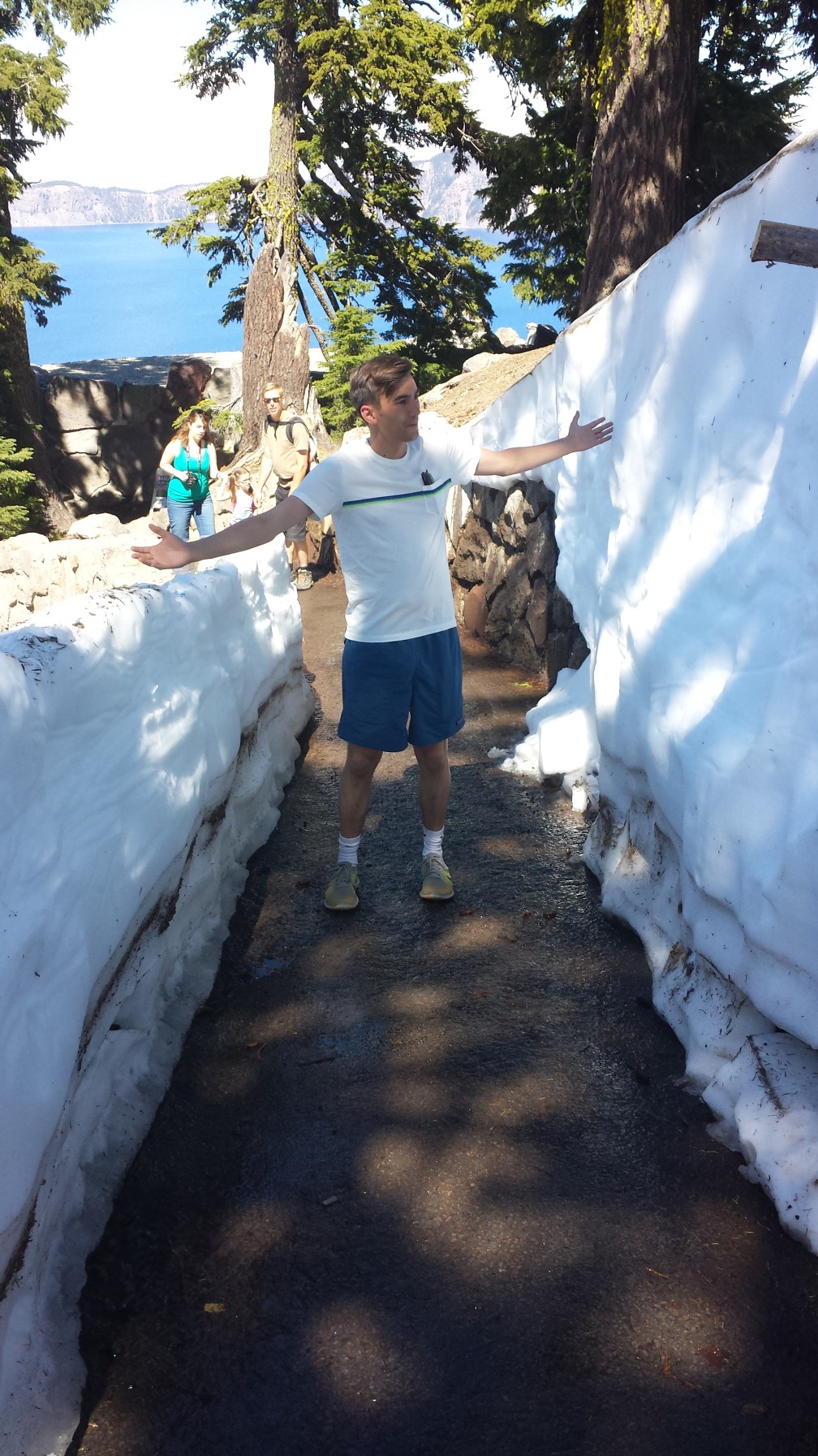
The road to Crater Lake starts out tamely enough, as it rolls through pinewoods and runs along a steadily deepening canyon. We’re clearly high up, though: there are hints of snow along the sides of the road. The switchbacks begin beyond the pay station, and eventually we come to open fields of fluffy white stuff, even under sunny 70-degree skies. We stop to play in it briefly, and come to the rim. Crater Lake is like no other: its deep azure waters plunge into untold depths. While just five miles across, the lake is more than three times deeper than Superior, its surface broken only by the cinder cone volcano of Wizard Island. The lake is the remains of a magma chamber for old Mount Mazama, a volcano that erupted with such force that it destroyed its whole peak and left just a hole in its place.

Perhaps a measure of the beauty of a natural site comes from the inability of a picture to capture it. I first had that thought at the Grand Canyon a year and a half ago, and by this criterion, Crater Lake certainly qualifies. I’ve seen plenty of ridges along lakes in my life—we Minnesotans are lake connoisseurs, after all—but one needs some perspective from the interpretive signs to understand just how far down it goes. The boat that heads out to Wizard Island in the center of the lake is pea-sized, and what looks like a small rock jutting out of the water is the height of a 14-story building. The ridges are colossal, shooting straight down in descents resembling ski slopes. A trail down to an overlook is a straight cut through a snowbank at one point, and while another trail we begin to explore is clear, descending hikers inform us that drifts further up make it difficult to traverse.
Even so, the rim is easy to enjoy. Stone paths line the south rim, and a winding road provides views all along both sides for the handful of months when it’s passable. A snarky Parks Service employee entertains a crowd outside a lodge, and we spent our picnic lunch amused by a girl who refuses to cooperate for the family photos. We endure another flagman and wind back and forth along the rim before spinning off to the north once again, our visit all too brief. We pass through old volcanic fields of rock before returning to long, straight roads through pine forests and sad towns. South of Bend, we turn west and make our way through a gap in the Cascades toward Eugene. More pines, a few more snowcapped peaks, and some beautiful glimpses of sun-flecked Lake Odell and another reservoir further along. It’s a lengthy descent down toward Eugene, where we make a brief, confused circuit of the University of Oregon campus. We pass befuddling parking systems, Duck decor, and the stadium for the national track and field championships before we re-connect with I-5.
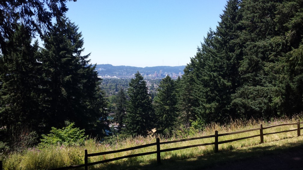
We arrive in Portland at just the right time, as the sun heads toward the horizon. It catches the buildings downtown and the bridges over the Willamette River, and the city sparkles and gleams. We meet up with an old family friend—our dads go back to their undergraduate days—and he and his roommate guide us on to the Portland streetcar to head downtown. Here, we meet a Georgetown friend now in Portland at the Deschutes brewery. Beer is essential Portland fare, and while Deschutes is technically from Bend and the biggest of the local brewers, it still delivers deliciousness. My eclectic dinner party comes together easily, and we savor elk burgers and trade life updates and jests, then retire to a second, more divy bar that lets me try another local beer before crashing on the couch.
Day 7: No Deception
We sleep a bit later than usual this morning, and once we stir to life, my friend gives us a tour of Portland. We pass through downtown in the daytime and make the requisite stop at Powell’s, a wonder of a bookstore with several floors and a massive collection. My sole purchase isn’t something unique to Powell’s or Portland, but it does fit with some of the road trip’s evolving themes: William Finnegan’s Barbarian Days, an excerpt of which in the New Yorker last year so engrossed me that I felt half-compelled to take up surfing on the spot. In the absence of my stolen books on disc, it will have to carry me through Montana and North Dakota later this week. Further thoughts to come.

The tour continues with a wander south through the city. I snap a quick picture of Mills End Park, the world’s smallest public park (a small tree in a median), and we make it down to the picturesque campus of Reed College. The pedestrian bridge at Tillikum Crossing gives views up and down the Willamette, and Hawthorne Street offers the perfect cross-section of Portlandia weirdness, curiosity, and pretention. Mount Tabor provides a view of the city, and a deliciously greasy lunch at Lardo’s rounds our stay in the City of Beards and Beer.
Portland is the first destination on this trip that I don’t think I’ve given due time: it seems like there are too many unexplored corners, and far too many beers left untasted. Above all, it’s a beautiful city, dense but leafy, and seventeen bridges cross the Willamette and tie it all together. It has the chill West Coast vibe that leaves me with mixed feelings, but it doesn’t have the ideology of a San Francisco: it’s quirky for its own sake, and its corners deserve further looks.
Canada summons us, however, so we’re back on the road shortly after two. Leaving Portland is slow going, with congestion between the Willamette and Columbia Rivers. We cross the first of many green-trussed bridges and head north across Washington, with Mount Hood, Mount Saint Helens, and Mount Rainier all rearing up at times along the road. Olympia passes in a blur of greenery, and we catch only fleeting glances at the port of Tacoma before we hit Seattle’s notorious traffic just after five. We’re reduced to a crawl for long stretches, though an HOV lane serves as a godsend, and we get a decent view of its major sports stadiums and downtown on our way through. Don’t worry, Seattle: we’ll be back.
We break off the freeway just north of the city and swing out to Mukilteo for a detour into Puget Sound. We catch a quick ferry out to Whidbey Island, which stretches some forty miles north from the entrance to Puget Sound, parallel to the shoreline before a road bridge reconnects it with the mainland south of Bellingham. From the decks of the ferry, we have quality views up and down the Salish Sea, the body of water separated by the Ocean by Washington’s Olympic Peninsula and British Columbia’s Vancouver Island, with the Strait of Juan de Fuca as its outlet. The road across Whidbey is a delight to drive. Aside from booming Oak Harbor, it’s a quaint isle littered with small cottages and occasional clearings filled with black cows. The sinking sun cuts through pine forests in ways that remind me of my favorite patch of woods back in Duluth. There’s something very homely about rocky, pine-studded shorelines at sunset.
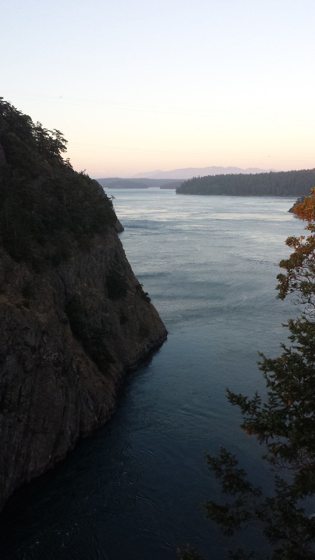
The real treat comes at a point known as Deception Pass, a pair of short bridges between Whidbey and Fidalgo Islands. We’ve timed it perfectly with the sunset, which lights up the straits and catches the pines and rocky shores. The narrows may have deceived George Vancouver when he first explored them, but they don’t deceive us: this is among the most beautiful sights we’ve ever seen, with sea and sun and cliffs and pines all coordinated in one great burst of magnificence. As if this weren’t enough, a large bald eagle wheels overhead and over the bridge for a moment before soaring off. A few minutes here justify the entire detour across the Sound.
Fidalgo Island ends on a bland note, with a refinery and a gaudy casino before we cross back to mainland. Still, the horizon rewards us, as the mountains over the coastal plain fade from purple to black. We rediscover I-5 and head north, once again negotiating construction around Bellingham before coming to the Canadian border. It’s an uneventful crossing, as the border guard sounds almost disappointed that we’re only spending two nights. We adjust to metric and take the highway north to Vancouver, heading through a tunnel and out into the city’s south end. We have a brief lesson in how much less the Canadians value freeways; ours disappears into city streets just beyond the tunnel, and after that, we briefly lose the highway. But when we find it again, it’s yet another superb view, this one of downtown Vancouver. We cross the Granville Bridge into the heart of the city, a dense peninsula covered with illuminated towers, and the streets teem with nightlife, even at eleven on a Tuesday night. We find our hostel, grab a bite, and crash. We have a full, mercifully car-free day ahead of us to explore tomorrow.
(Part IV)

3 thoughts on “Road Trip Journal III: San Francisco to Vancouver”