It is August. After a social spring and summer, it is time for my annual retreat to a wilderness in the West. Bob, Rob, Amy, Ed, and I are ready to disappear into the mountains yet again. It is my fifth time joining this group on its yearly venture, and this time around I saddle the group with an itinerary in a new mountain range I’d seen from a distance and deemed worth exploring. We are off to the Cloud Peak Wilderness in the Bighorn Mountains of Wyoming.
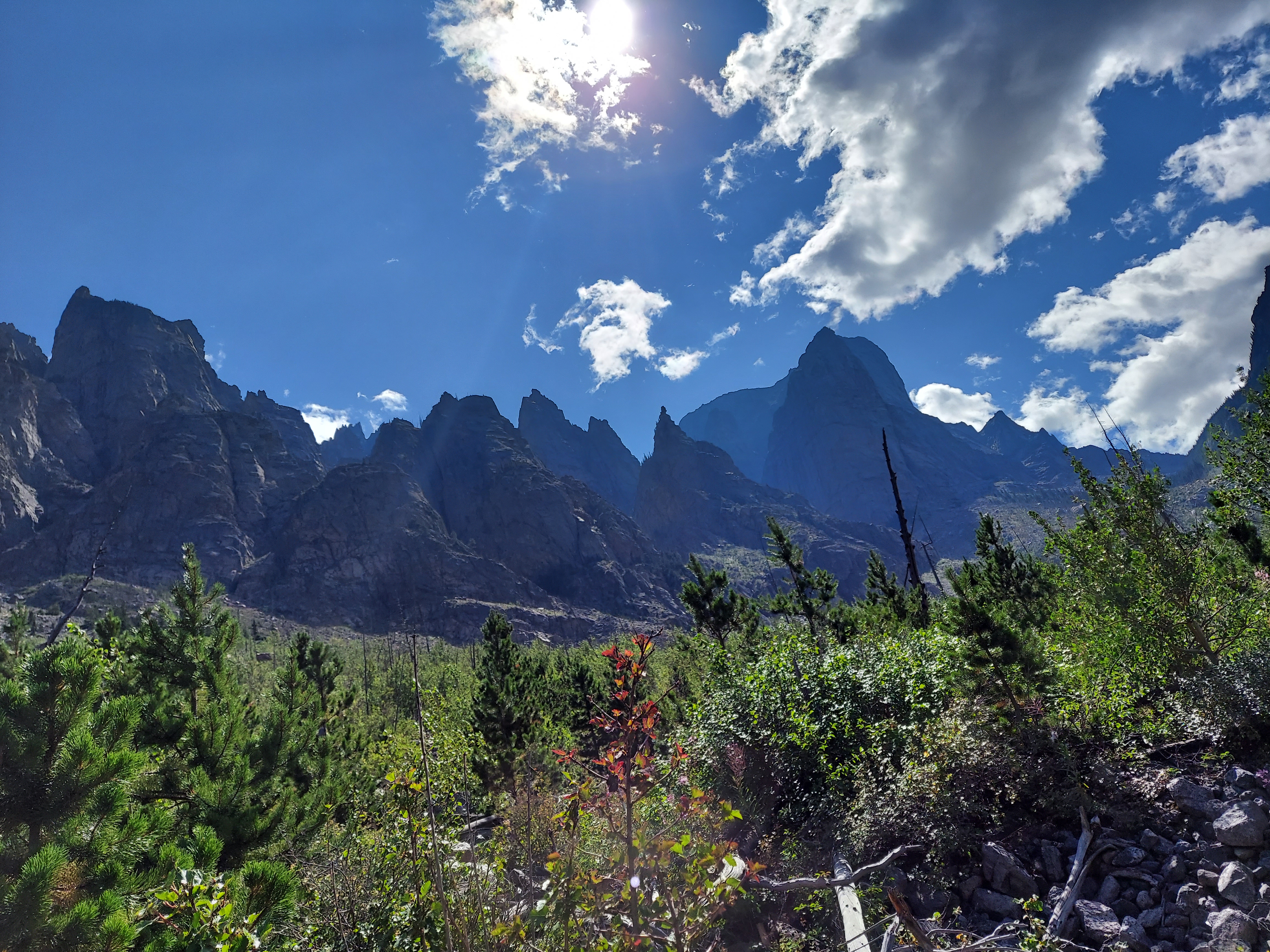
The Bighorns stand to the east of the Rockies as a lonely outpost of high elevation, a prominent range separated from others by twin vast open expanses, the Absarokas by the Bighorn Basin to the west and the Black Hills by the Powder River Basin to the east. They sit far from any other major attraction, save perhaps a road tripper’s route to Yellowstone and the Tetons and the Little Bighorn battlefield. The two gateway towns, Sheridan and Buffalo, combine for about 20,000 residents (granted, a veritable metropolis by Wyoming standards) and little of the seasonal surge in population that descends on other high country access points we’ve visited in the past, such as Red Lodge in Montana or Leadville in Colorado. They feature no national park or monument, no 14,000-foot peaks, no iconic roadside attraction to lure in the I-90 road trippers, many of whom may now even take the Google Maps-endorsed bypass on US 212 from Spearfish to Crow Agency, thereby avoiding Bighorn country entirely. For that matter, the range’s namesake sheep, decimated by early white settlers, have only been reintroduced in one northern pocket of the mountain chain.

What the Bighorns are is a rougher edge of wilderness. Here we find more extreme weather, more creek crossings, more horse poop, and bigger boulder fields than we have seen elsewhere. We find both solitude and trails more traveled, and a smorgasbord of Western experience, from rough frontier edges to the encroachment of coastal cosmopolitan comfort, from wide open freedom to the memory of loss that lingers in places like the Crow Reservation we drive through on the way to the trailhead. These rocky slopes provide everything a good hike should.
The hike goes awry quickly. After a leisurely stroll from the Hunter Trailhead on a rough road used by horses and ATVs, we take the alleged scenic route on the Ditch Trail, whose name alone should have been a warning. It starts out clear but muddy, tracking a flume-like creek running down from the mountains, but after we cross it, we promptly lose the trail and end up whacking through a dense thicket of 20- to 30-year-old pines as it begins to rain and hail. GPS gets us back on the putative path, but it clearly had not been maintained in years, as we are left to circumnavigate thousands of down trees and miserable swamps that afflict the occasionally visible ditch that give the trail its name. We are lucky this is day one and we have the energy for this slog.

Once we get back another horse and ATV road, we can finally cook along through mid-altitude forests and across alpine meadows, past the graves of a few lonely frontiersmen and through variable precipitation before we land at a respectable campsite near a creek crossing. It clears up enough to enjoy the evening, and a large moose cow wanders by after dinner. Day two is day of creek crossings as we head higher up Florence Pass, a steady push upward with pauses to step gingerly through frigid waters. The rain and hail hits on an exposed stretch of rocky trail above 10,000 feet, and we take shelter in a cave just large enough for the five of us, where we wait out the worst of the storm and eat lunch. Rob’s garbage bag turned pack cover blows off down the canyon, Amy is quite done with creek crossings, and when we get to Florence Lake, our planned destination for the evening, we discover a rock-strewn, barren shoreline with near zero flat ground to pitch a tent.
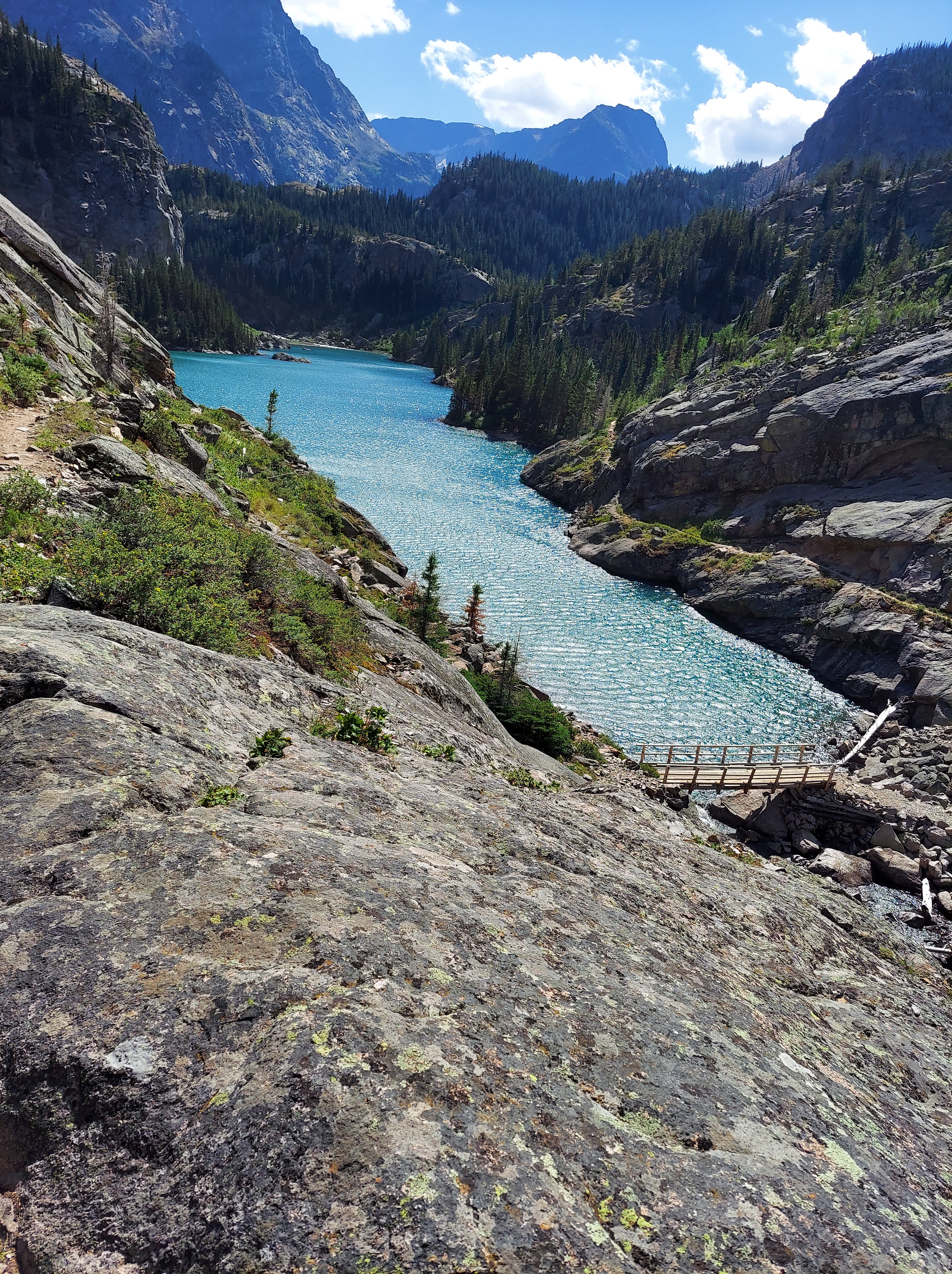
Not enthusiastic to go any further, we scope out some halfway acceptable tent pads up a slope from the lake and make camp. Despite its obvious deficiencies, Florence Lake is a beautiful place to settle: stellar waterfalls tumble into the pristine waters, and the mountains glow golden at dusk as the sun finally emerges from the clouds. Across the lake are the wide arms of Bomber Mountain, on whose slopes a World War II era warplane’s remains lie; behind us is Florence Pass, the high point of our hike at 11,000 feet, and a commanding view of the lakes down the next valley is just a short stroll away. It is a chill night, frost on the tents and pack covers in the morning, and the need to thaw it all out becomes our excuse for our usual slow exit from camp.

On day three we descend from Florence Pass along a series of lakes before we come to the busier corridor that links the West Tensleep Trailhead (our exit point) with Mistymoon Lake and the trail up Cloud Peak. We have found the open high country at the heart of the Bighorns, and finally, the weather cooperates and gives us free sightlines of rocky peaks and tangled heath and a series of brilliant lakes. A giant bull moose hugs the shoreline of Mistymoon, and we score a prime campsite at the base of a base of a waterfall in a valley that serves as a staging bowl for assaults on Cloud Peak. All trails in the southern Bighorns seem to lead to this small stretch, and for good reason.
After two days of solitude, we know we’re in for a different experience when we encounter a herd of horsemen all conspicuously packing heat. On our other hikes, most of the people we encounter are typecast backpackers: young adventurers, veteran wilderness explorers, people who seem born to be part of nature. In the Bighorns, we find much a greater variety: a lot of families, some salt of the earth locals, a general excess of cowboy hats, and in one case a kid hiking in cowboy boots. We admire the dad from New Mexico with his three backpack-toting kids, ages nine, six, and five, all cheerily bearing their loads and off on fishing excursions in the alpine lakes. The fellow travelers we get to know best are Brandi, a Wyoming native whose parents have finally accepted her itinerant lifestyle, and Oliver, her Salvadoran partner with roots in Brittany. They met when Brandi signed up to crew Oliver’s sailboat in Grenada and they have since traded sailing for the van life, which has now led them to the Cloud Peak Wilderness. We share a site with them for a night, and suddenly we are discussing sailing and Salvadoran politics and migration and gang violence over our respective freeze-dried and packaged delicacies.
On day four, Bob, Amy, and Ed take it easy with a day hike to Solitude Lake, while Rob and I wait out a thunderstorm before we tackle Cloud Peak, the highest point in the Bighorns. While its summit at 13,171 feet doesn’t rival the Rockies’ fourteeners, this push upward is substantially harder than our conquest of Colorado’s Mount Massive a year ago. Part of it is a route problem: several people we chat with and a guide I’d read suggested that, on the way up, we should cling to the ridge on the right. This advice, in the words of a Scandinavian man we chat with high on the saddle who’d followed the same guidance, is “moronic shit.” It results in an extra hour of bouldering instead of a fairly straightforward surge up along a creek and an easy runoff ramp, albeit with some impressive views.

Even so, the bouldering is inevitable over the last 1,500 feet of the climb, up through crags and around crevasses and past the few snow fields that linger late into August. We summit around 2:30 PM, blasted by winds gusting up to 50 miles per hour, and begin the steady rock hop down. The slopes are relatively empty: besides Rob and I, the climbers on this day include the Scandinavian man and his Asian wife (plus their teenage son, who bails at the saddle), Brandi and Oliver, a family with a dog who make the whole affair look like a walk in the park, and three similarly sprightly young men, their footwork as they dance from boulder to boulder leaving me in awe. On the way back we cruise down the ramp but are still left with some rough scrambles as we sort our way through the haphazard cairns marking the route.
After a second night at the foot of Cloud Peak, we hike the eight miles out down West Tensleep Creek. The first half is a scenic stride past three lakes shimmering in the sun, but the final four miles are more of a slog through woods and mud, though they are livened up by an ongoing game of tortoise and hare we play with a group of teenagers and their handlers. Their antics at a final crowded stream crossing leave Bob and Ed, longtime guides of boy scouts on camping excursions, reliving old dramas. Finally we stumble out to a crowded trailhead, back to civilization and backlogged emails and requests for my takes on a shocker in Duluth’s mayoral primary.
We begin and end our journey in Billings, home to the nearest airport of substance. It is a regional center; on an east-west axis, it is the largest thing between Fargo and Spokane, and the spot where two major cross-country interstates meet. This status gives it some good institutions for a hub of its size, a crossroads of industry whose main draw is its proximity to other things. In my previous three visits I saw it only as a launch point, but as we spend some time here this time around, its culinary scene throws in some genuine surprise. Juliano’s, a converted old home with a Hawaiian chef, is one of those small city strivers ahead of its curve, brilliant but underappreciated. The Granary, in spite of its barnlike structure, provides a little window into Mediterranean basin fine dining. As a fervent defender of Billings-size cities, I applaud the progress here on the western edge of the Great Plains, though I am sure a few locals can only shake their heads.

I think back to three years ago, when I first drove these open roads around Billings. It was deep in the Covid summer of 2020, and the West felt like the land of restless freedom and sorrow that has formed its myth. This time, we debate several forms of life on display here. There is the gun-toting machismo, most charitably viewed as an extension of a brave frontier ethos and a can’t-be-too-safe caution in a land where crime is rare. On the flip side is a fetishistic continuation of a lone wolf myth, to say nothing of the solitary lives ended late on lonely nights on the prairie. (Wyoming has the dubious distinction of the nation’s highest suicide rate five years running, with Montana right behind. The correlation between firearms and the completion of a choice not to be is not hard to see.) And then it will always attract the Brandis and Olivers too, the free spirits who find, in its vast open spaces and its growing subcultures, a place where they can live cheaply and freed from societal constraints, at liberty to roam and shed obligations to the past. Is their way of life a bold pursuit, or a frivolous retreat from the commitments that give a life meaning? Opinions differ among the five of us, all urbanites with comfortable careers who make an annual escape; time may also render such questions moot. For now, the West accommodates them all, and at its best gives families like our New Mexican friends a playground to raise kids to explore and achieve away from the monotony of overprotection and screen life.
For us, however, it is just a snippet, a taste of the wilderness that can carry us through for another year. Before next time I have new gear to buy and routes to plan, and after a summer with a lot of time on the road, I am ready to settle back in to Minnesota life for a spell, too. Until then, the West will linger there for us, that allure eternal.