A Landscape of Yearning

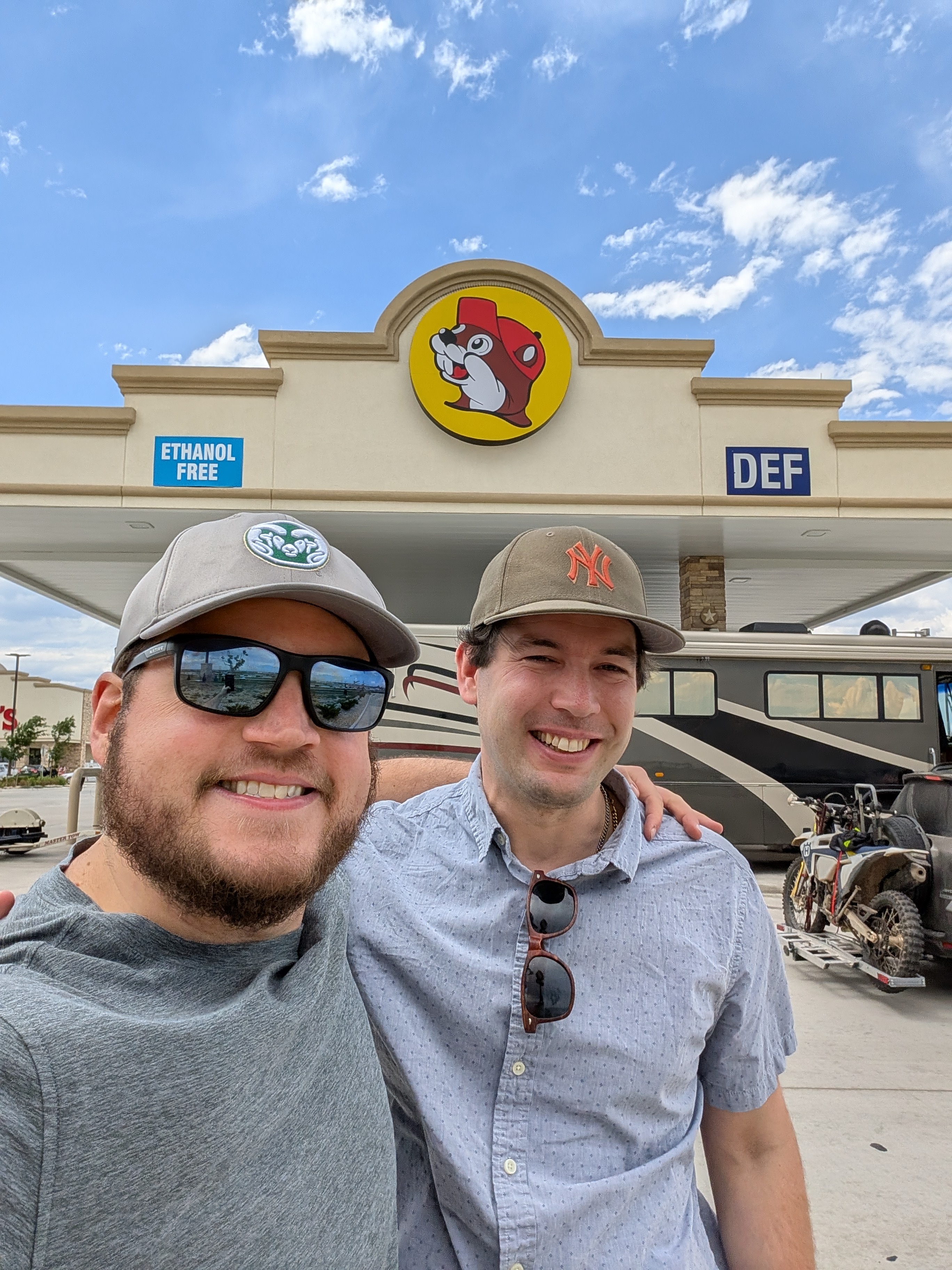
Last year I wrote that I go west for new beginnings, but this year’s trip starts with a blast from the past. I start my annual venture with a diversion away from my hiking crew’s rendezvous point in Denver and head to Fort Collins, Colorado. This Front Range college town exceeds all expectation with its verdant core, a green grid with a pedestrian mall and college bars and teeming life. A good guide helps, of course: in this case it is Joe, one of my oldest friends, a connection sustained since second grade. He gives me and a few of his friends a behind-the-scenes private tour of New Belgium, a leisurely three-hour affair that goes deeper than any other brewery visit I’ve done. The night carries on from there into the morning, dinner and drinks and debate and a blending of worlds would never have otherwise mixed. And yet it is as if we have not missed any time, our interests evolving on parallel tracks into the political world and urban planning and good beer too. This is a deep cut at a time of deep feeling, one in which words do not always come easily to me as feelings surge and demand examination, but a certainty in the paths I trod only grows.

As kids, Joe and I bonded over the Civilization computer game franchise, a fond memory for several people in our Fort Collins dinner party. That game had a certain influence on my way of being: a desire to build worlds, to advance a society toward greater glory, and perhaps to leave the Babylonians in smoldering ruins. But the game has to stop here and there, and it is time for my annual escape from civilization with my usual backpacking crew, a ritual renewed.

The venture gets off to an inauspicious start. Ed, a stalwart member of our party, injures himself on the drive west and has to abandon the trip. Our planned acclimation day-hike at the Black Canyon of the Gunnison goes up in flames as a wildfire shuts down that national park. We plan to start our official hike on the Bear Creek Trail just south of Ouray, but trail maintenance has closed that, too. As we pull up to the Middle Fork trailhead instead, signage warns us that several hikers have been attacked by sheepdogs, including one party just nine days before we set out. But the show must go on. Amy, Bob, Rob, and I head for the Uncompahgre Wilderness in the San Juan Mountains, an escape even many Coloradans do not know. This, I say, is kind of the point.

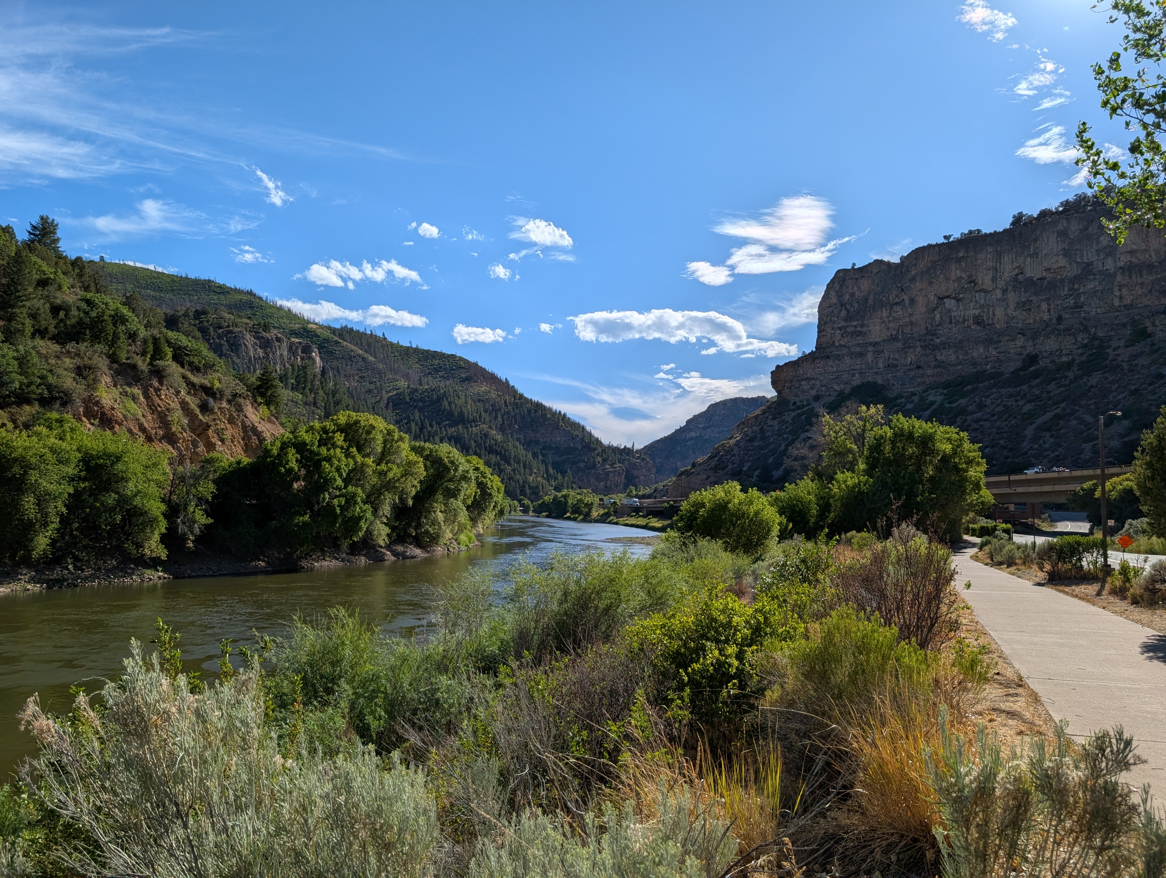
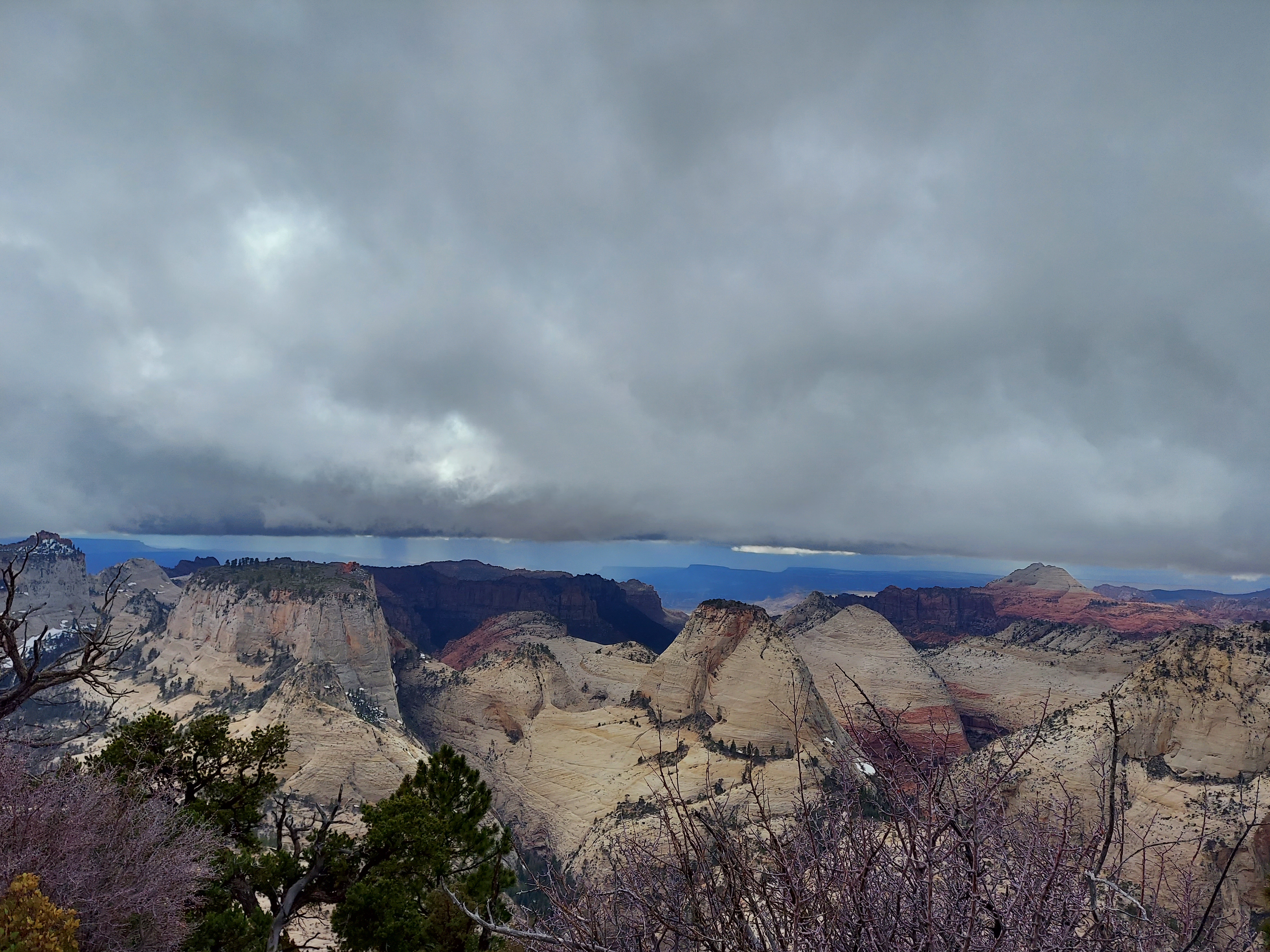
West of Denver, I-70 is the scenic showpiece of the interstate highway system. I have memories etched in amber of an Amtrak venture down this corridor at age fourteen: gazing out the observation car through Glenwood Canyon, the divinity of a Palisade peach. Somewhere on these stretches, beyond the Front Range traffic and the most extreme grades at Loveland and Vail Passes, I find my western release. We cruise down an austere river valley where dusty towns watch the world fly by, a simultaneous invitation offered and challenge posed by a landscape of yearning. It calls forth, speaks of more to find. Its treasures draws in seekers, from 19th century gold to today’s powdery slopes, from conquest of fourteeners to backcountry solitude. The Western Slope is far from the cradle of familiar northern Minnesota woods, not a safe harbor but land that won’t ever quite be so well charted and is all the better for it.

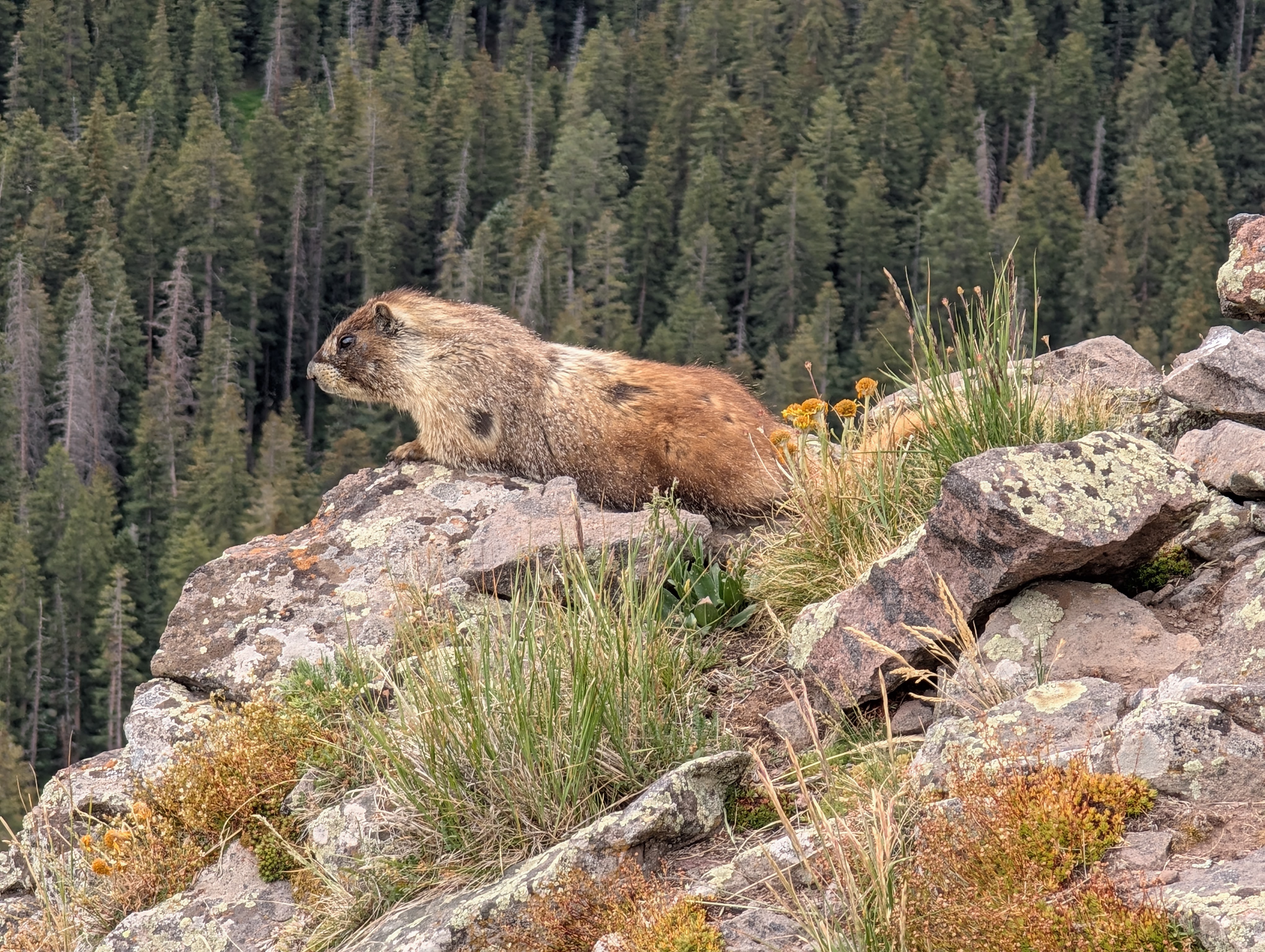
The alpenglow over the Uncompahgre beckons as we swing south from Grand Junction for a night in Montrose. We summit Courthouse Peak for a warmup hike and scramble, gaze down on the field where John Wayne finished off some bad guys in the original True Grit, and enjoy the company of a fat marmot on top. We spend the next night in Ouray, a vein of gold tucked between red cliffs along the Uncompahgre River, its sloping Main Street in classic Colorado style leading up toward the Million Dollar Highway to Silverton. Here we enjoy one of our best pre-trail meals ever at Brickhouse 737, though my pasta with rabbit cannot compete with the eight-year-old at the next table who orders the hibachi smores and roasts his marshmallows over a small flame. We pack in record time in a cozy motel beside the rushing river, breathing easier after a few days at elevation. It’s time to enter the wilderness.

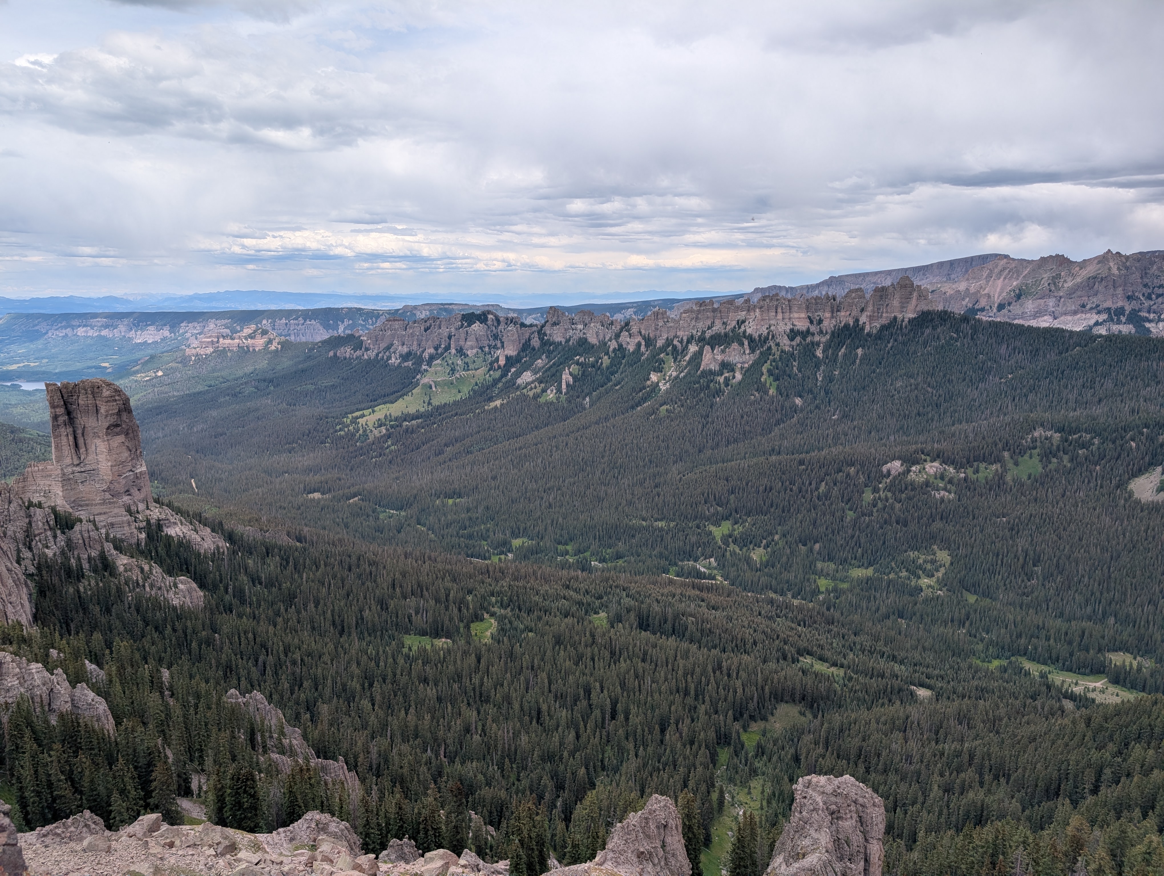
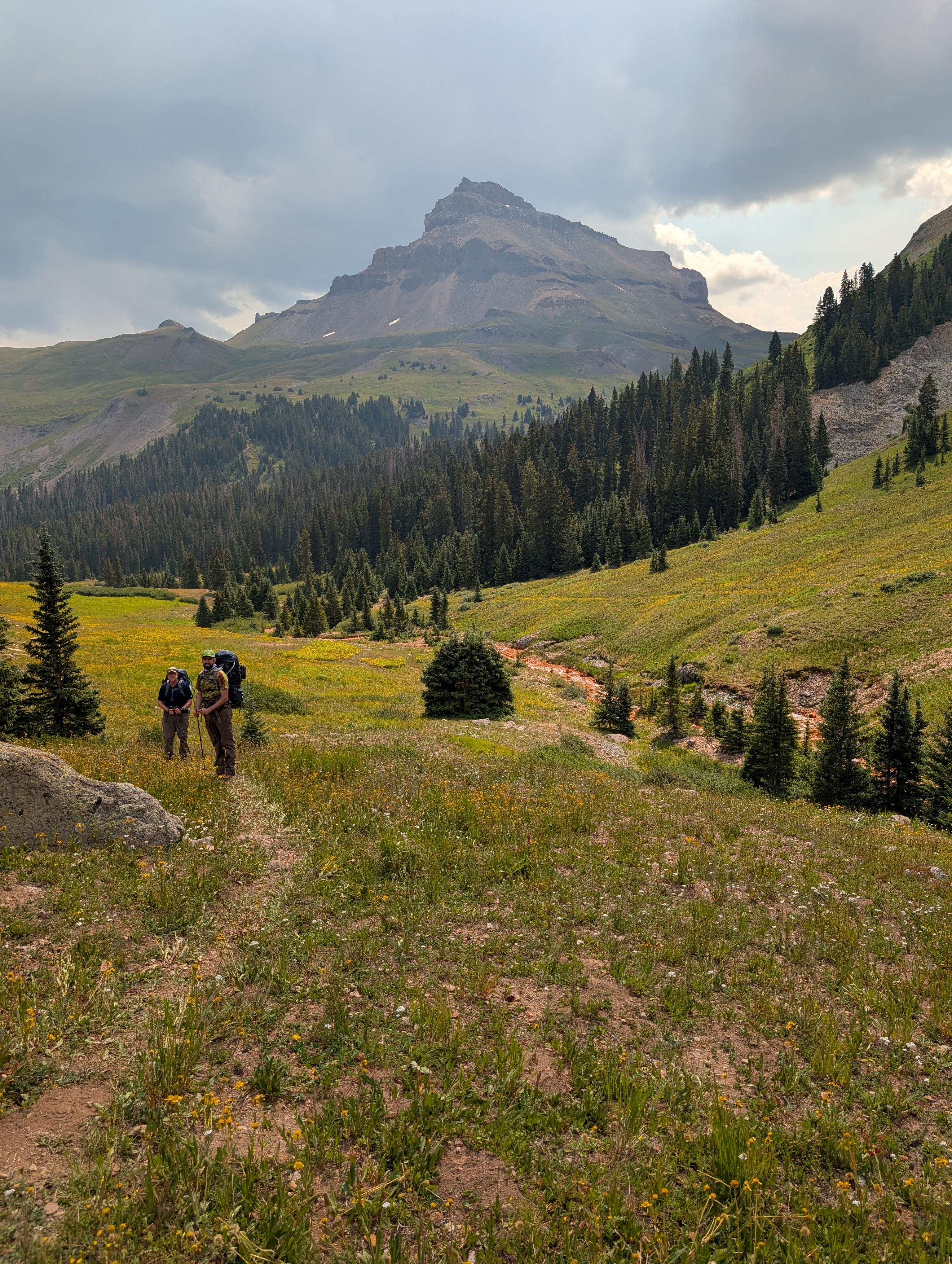
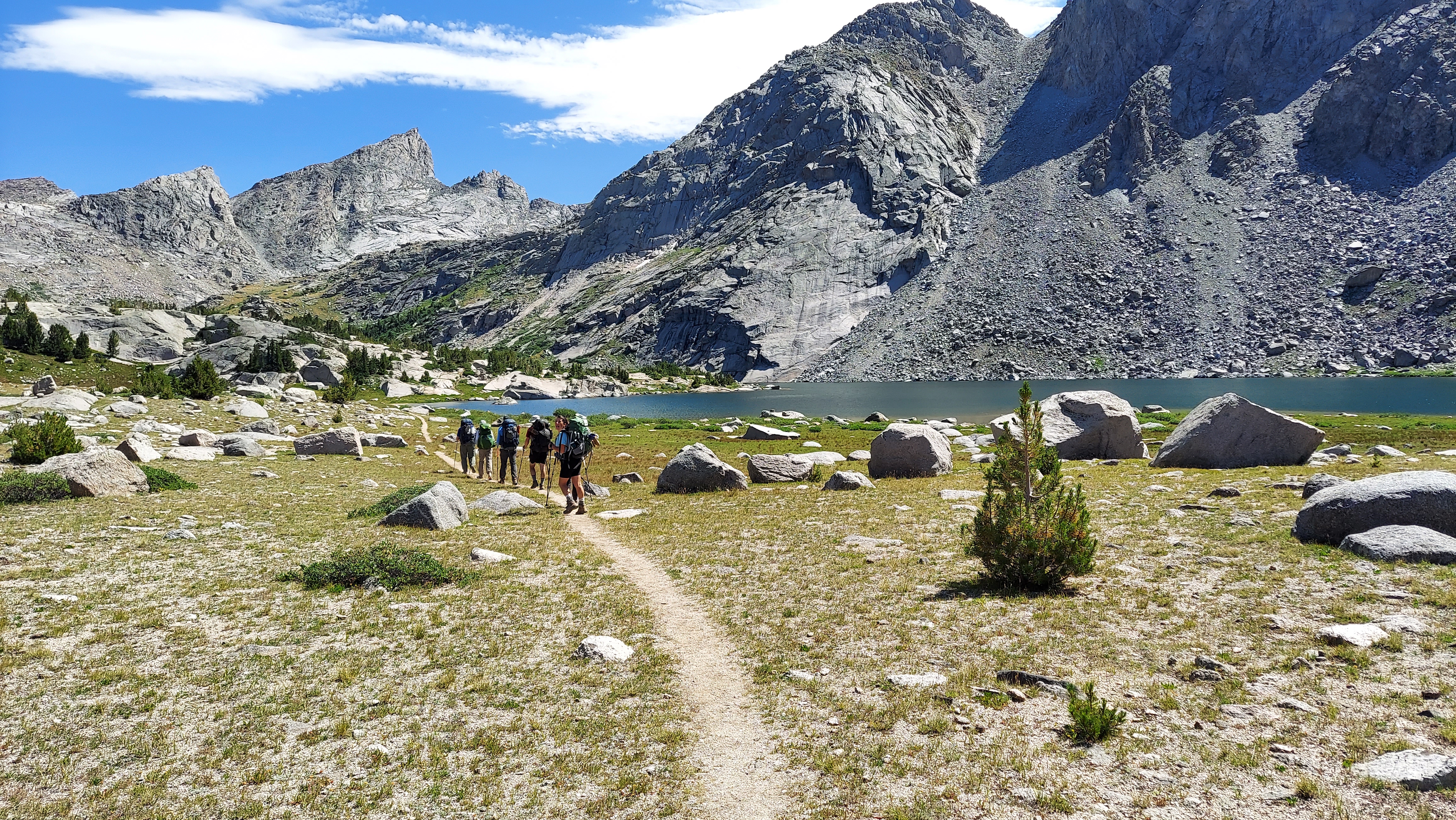
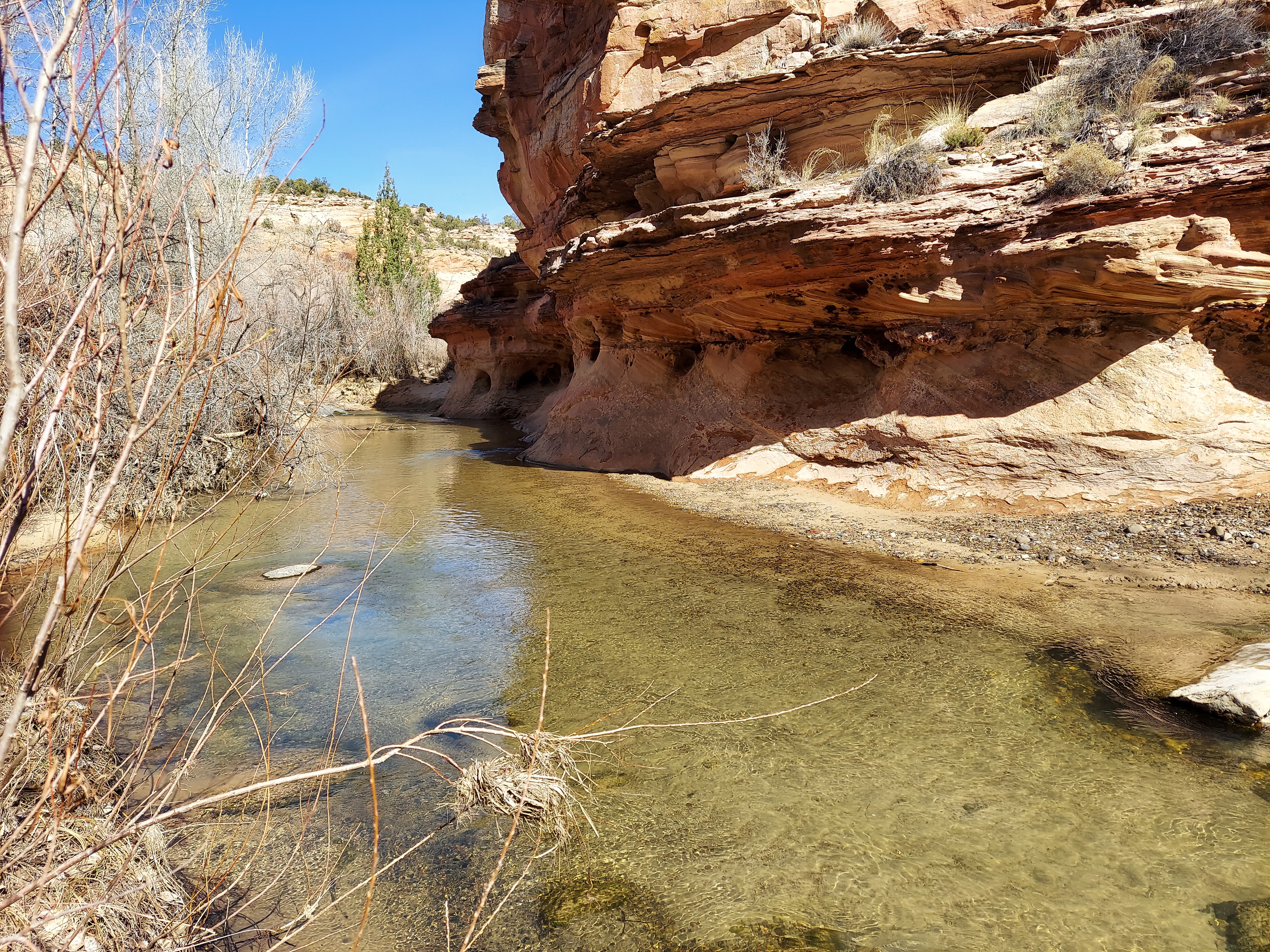
Oftentimes on these trips the first day is a plod to get to nicer things, but in the Uncompahgre, the beauty is immediate. The valley of the Middle Fork of the Cimmaron River, one of three long tines cutting into the northern side of the wilderness, is just wide enough to show its ramparts, a jumble of jagged peaks reaching skyward. We camp the first night atop a meeting of rushing streams, with views up the bowl to the south and down the Fork to the north. The sun bathes the valley in gold as it sets, and a faint crescent moon gives the night a touch of light. All is quiet, and I am where I want to be.

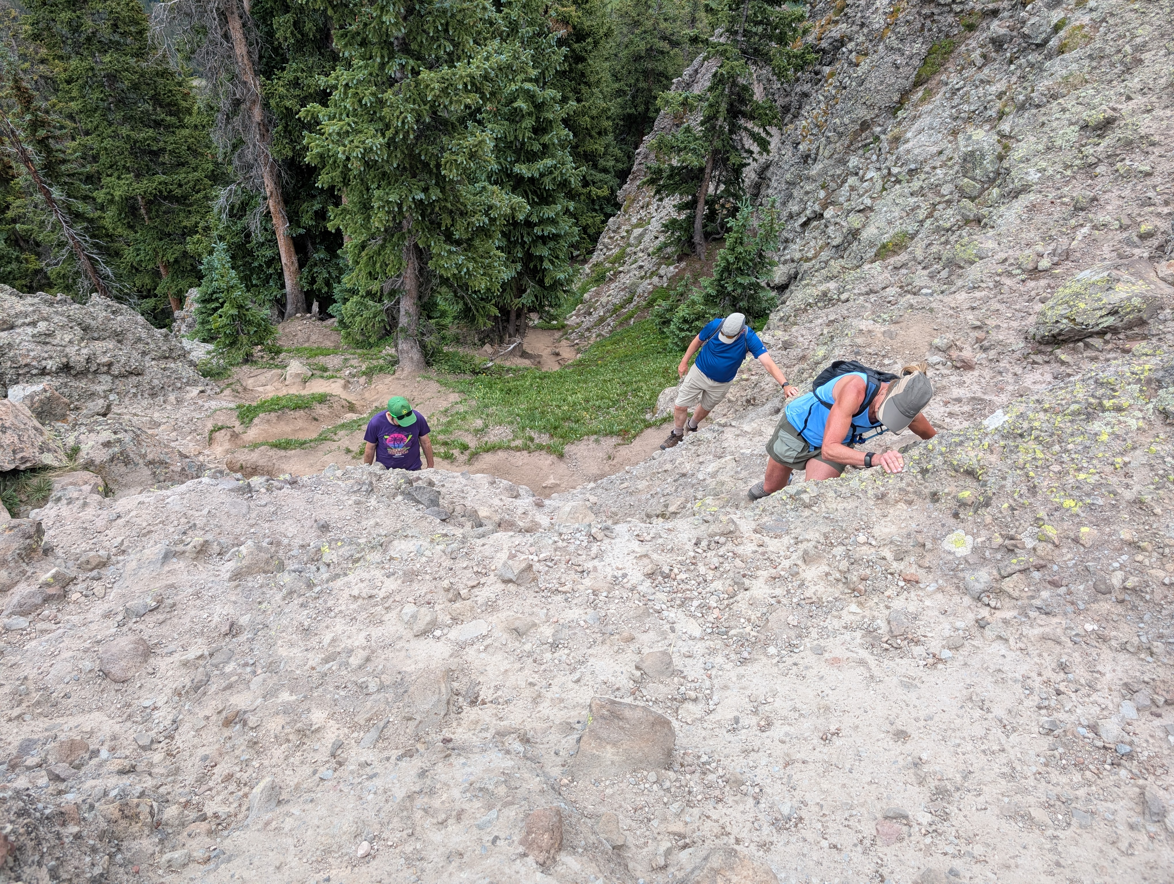
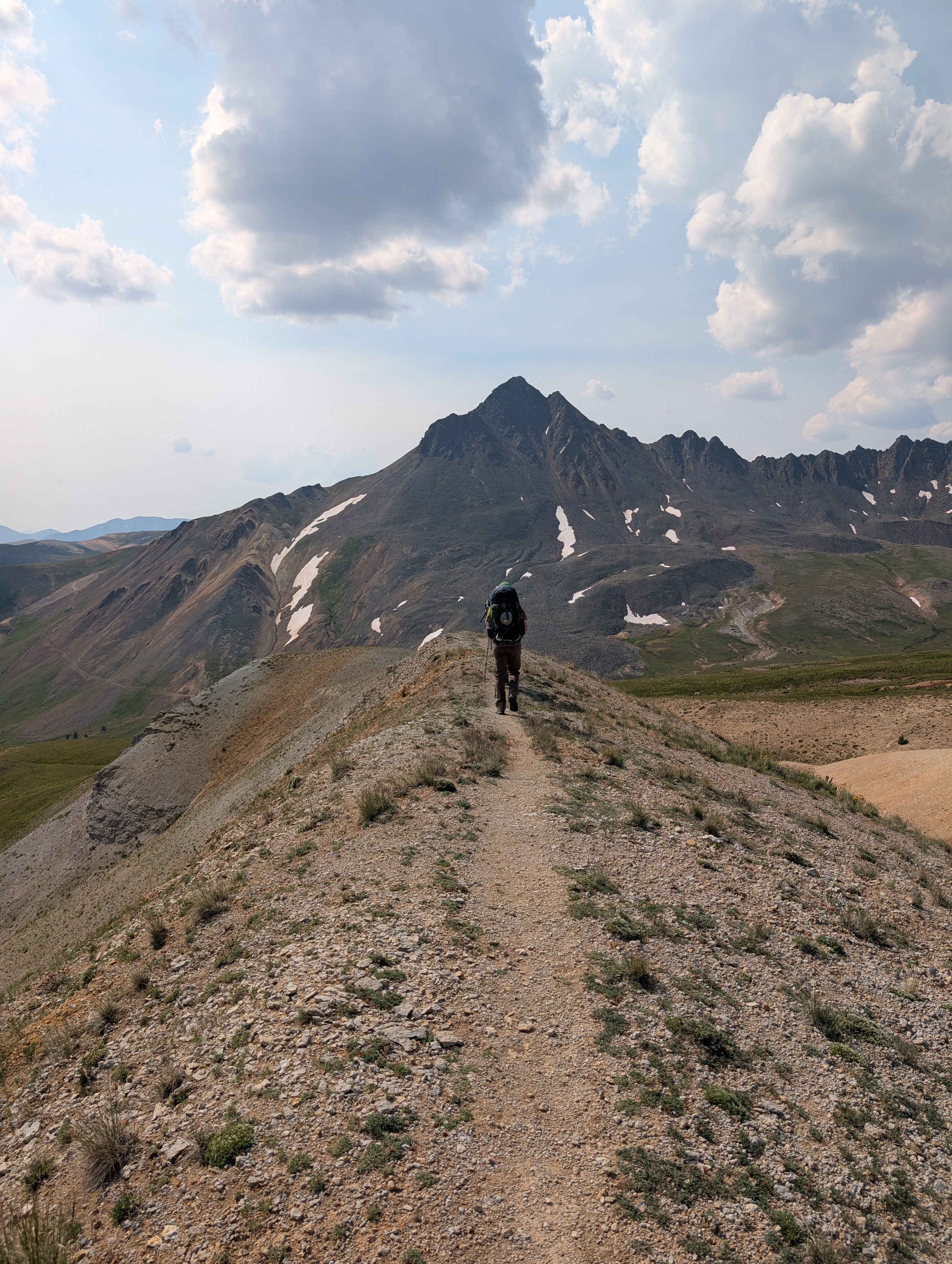
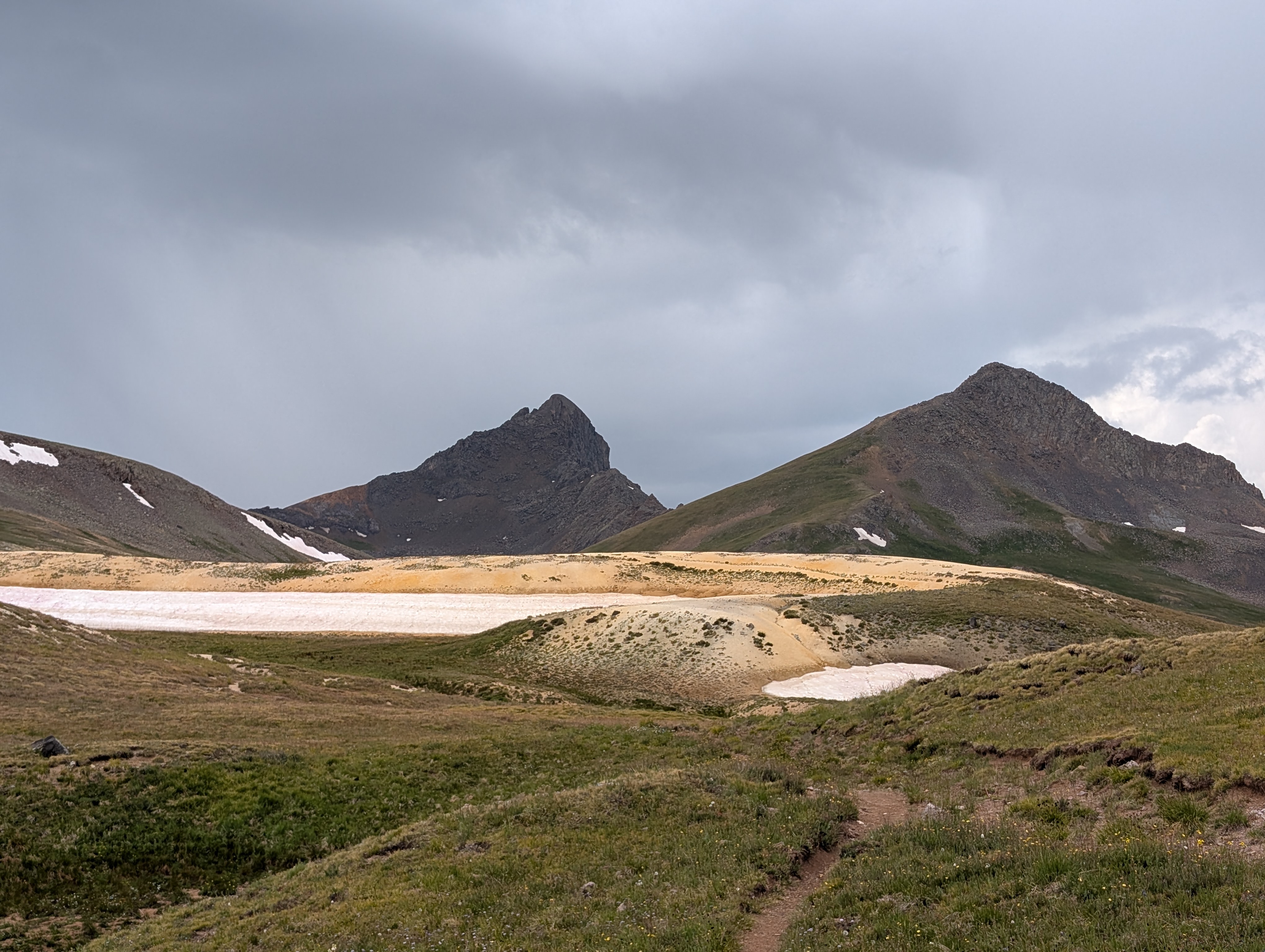
On day two we immediately climb 1,000 feet to a pass between the Middle and East Fork drainages. After we rise above the trees we are in an upward sloping glade of yellow flowers, and after a steady push we come over a pass that reveals the three greatest peaks at the heart of this wilderness: the striking Wetterhorn; the Matterhorn, reminiscent of its namesake Alp; and, to the east, a broad beast greater than all of them, Uncompahgre Peak. With eyes still turned upward at the giants around us we descend from the pass, ford an orange-tinted creek, and scramble up a lightly maintained shortcut trail to an eventual camp by some falls on the East Fork at the root of Uncompahgre. We are settled into camp before the afternoon storm rolls through.

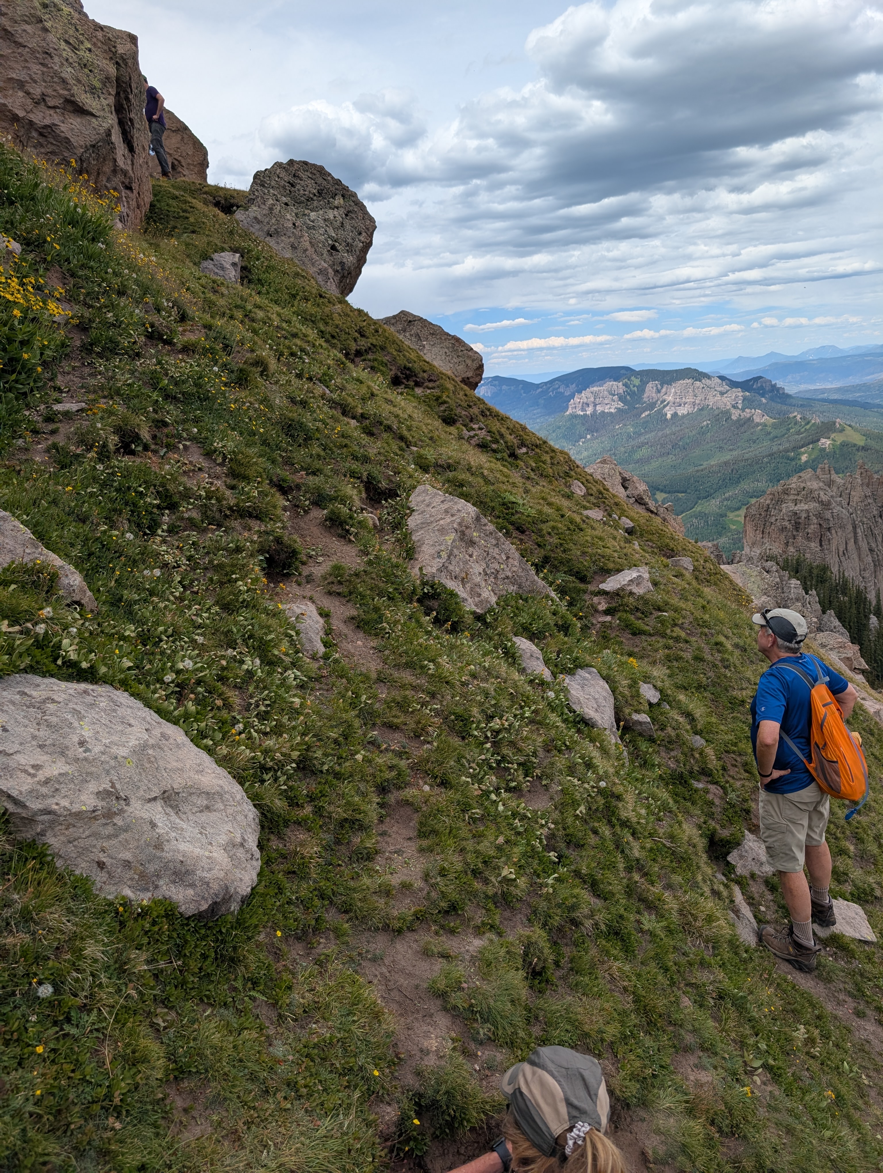
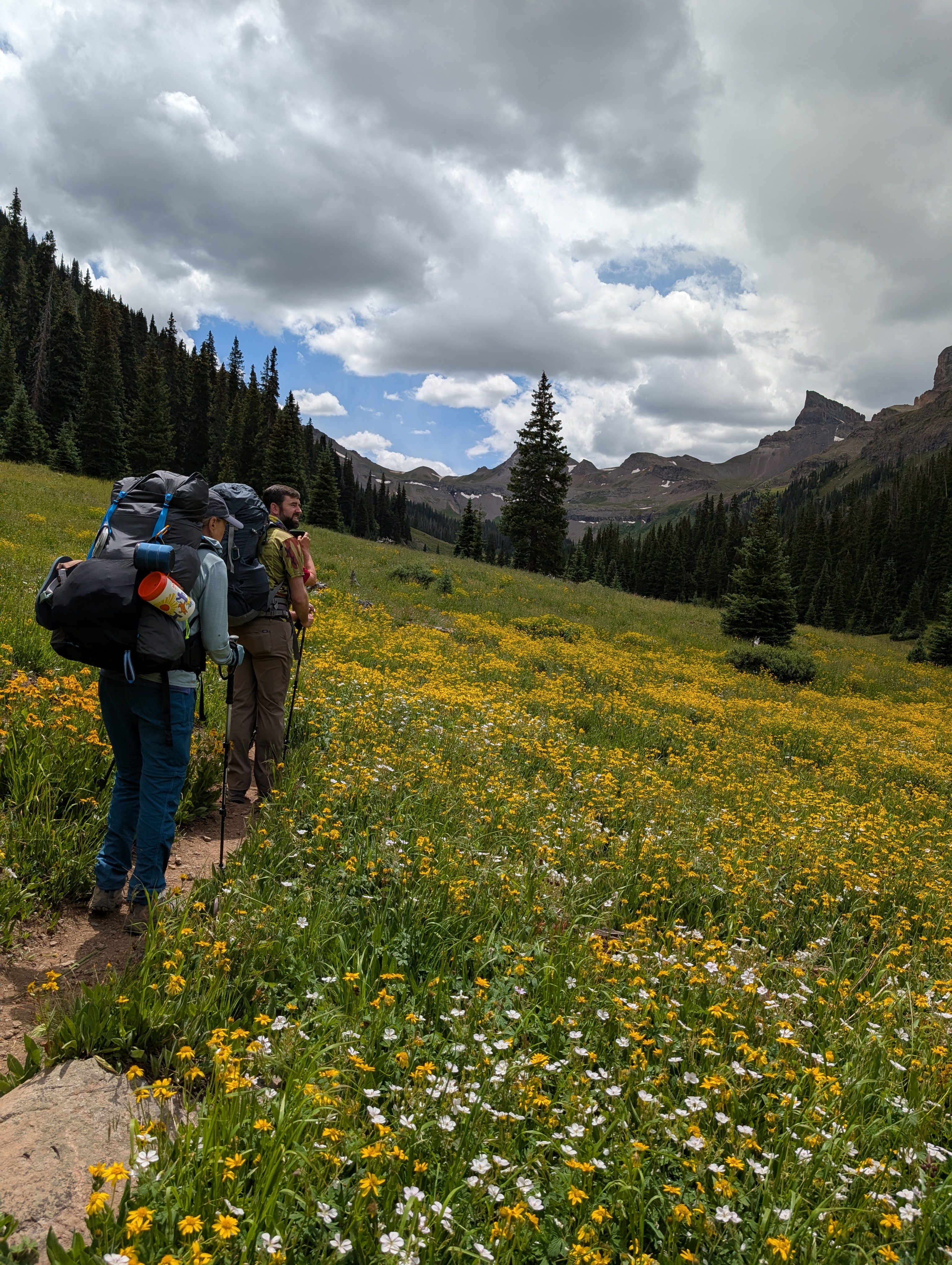
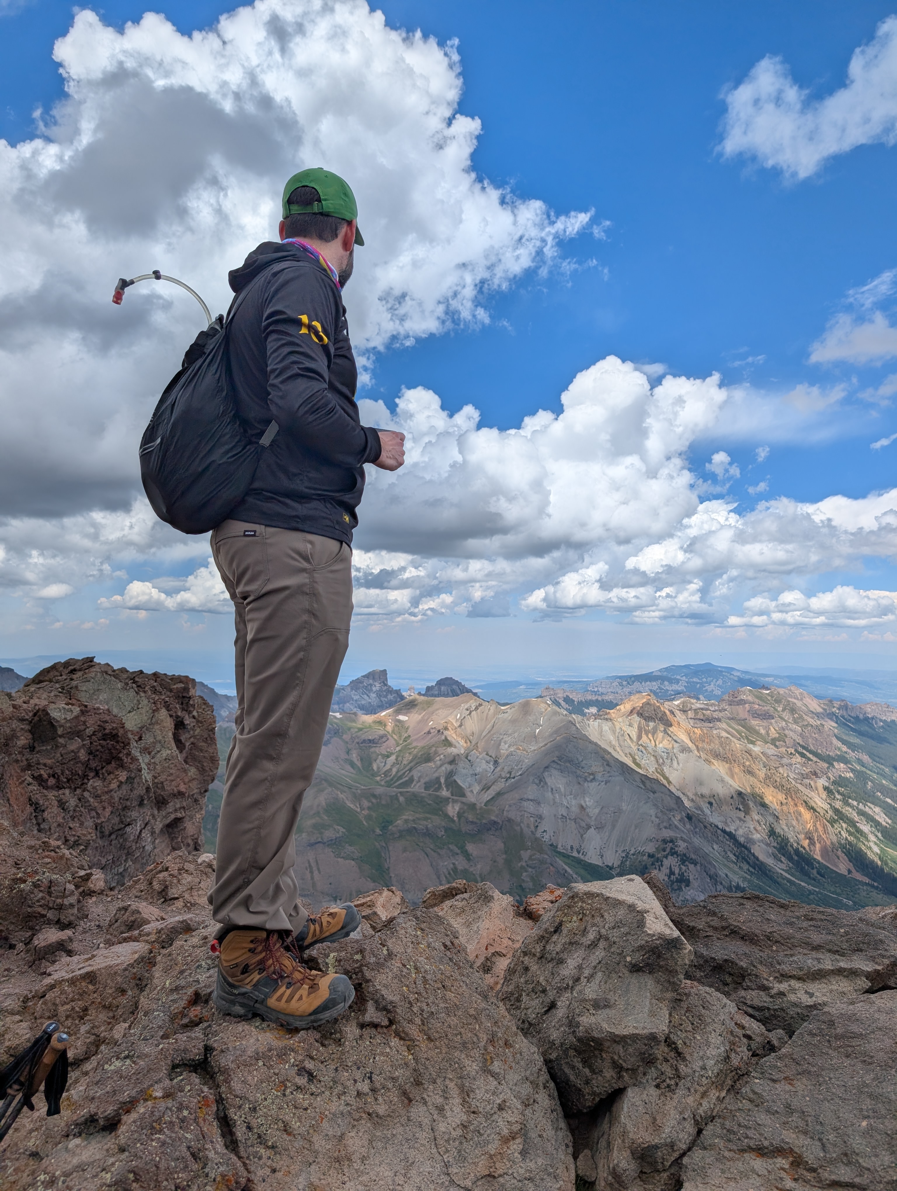
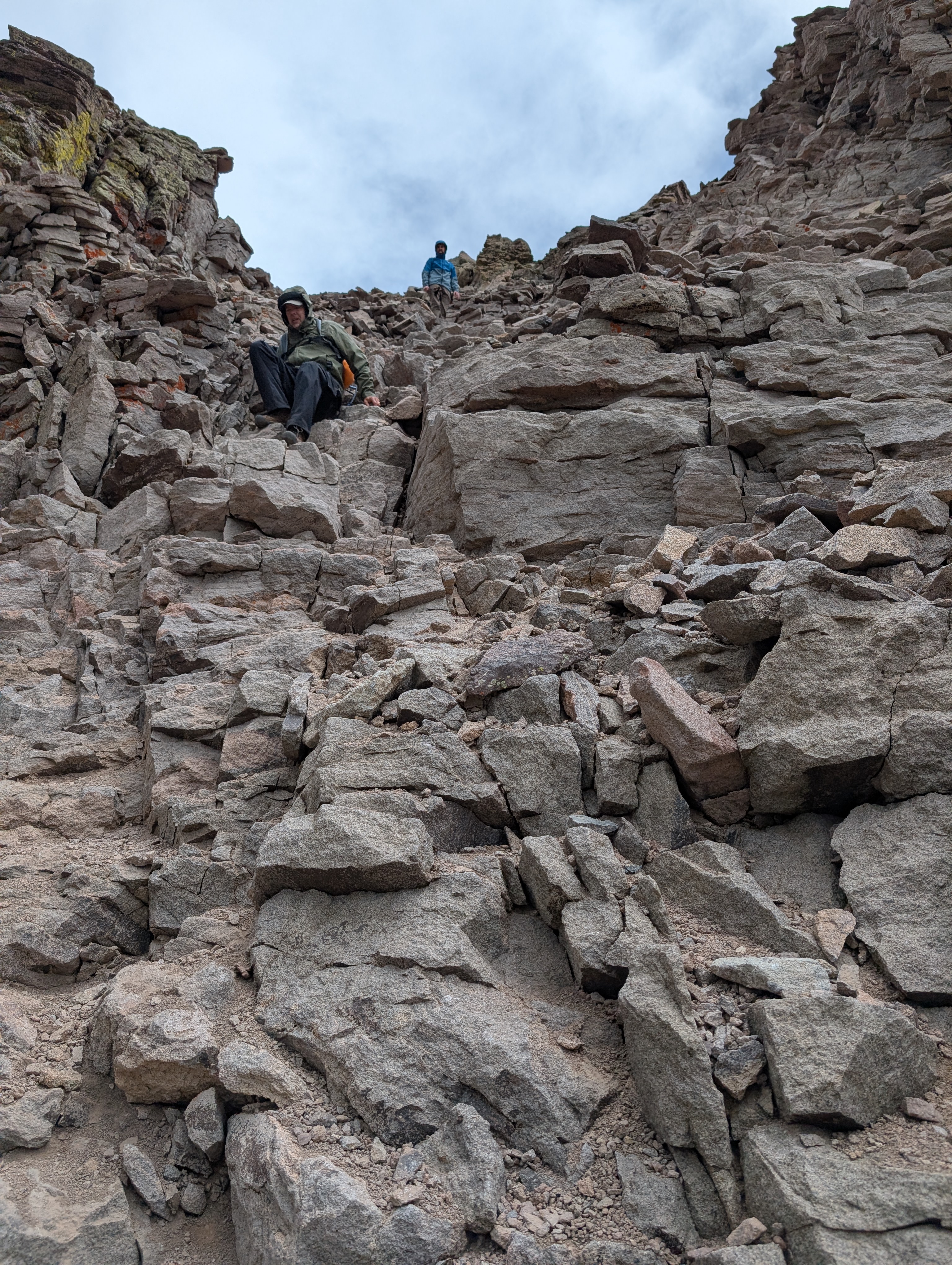
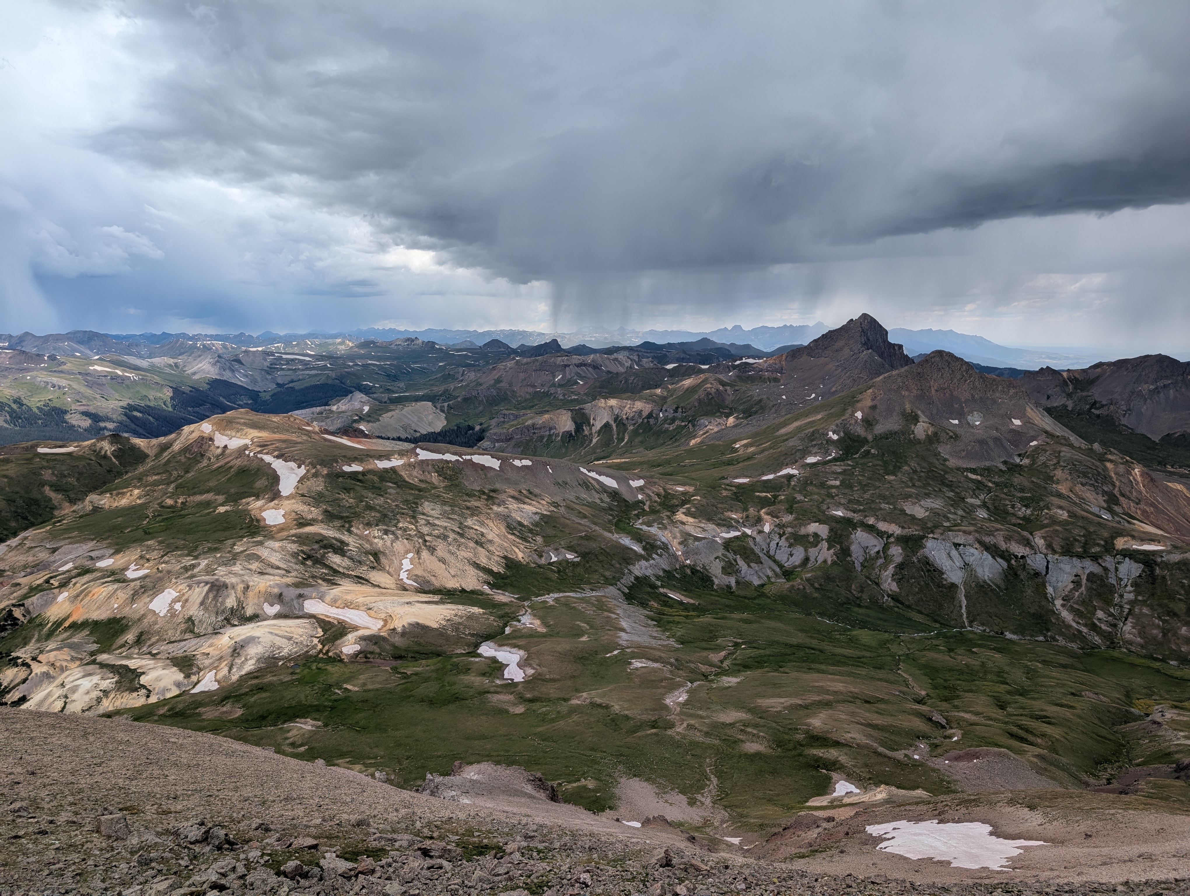
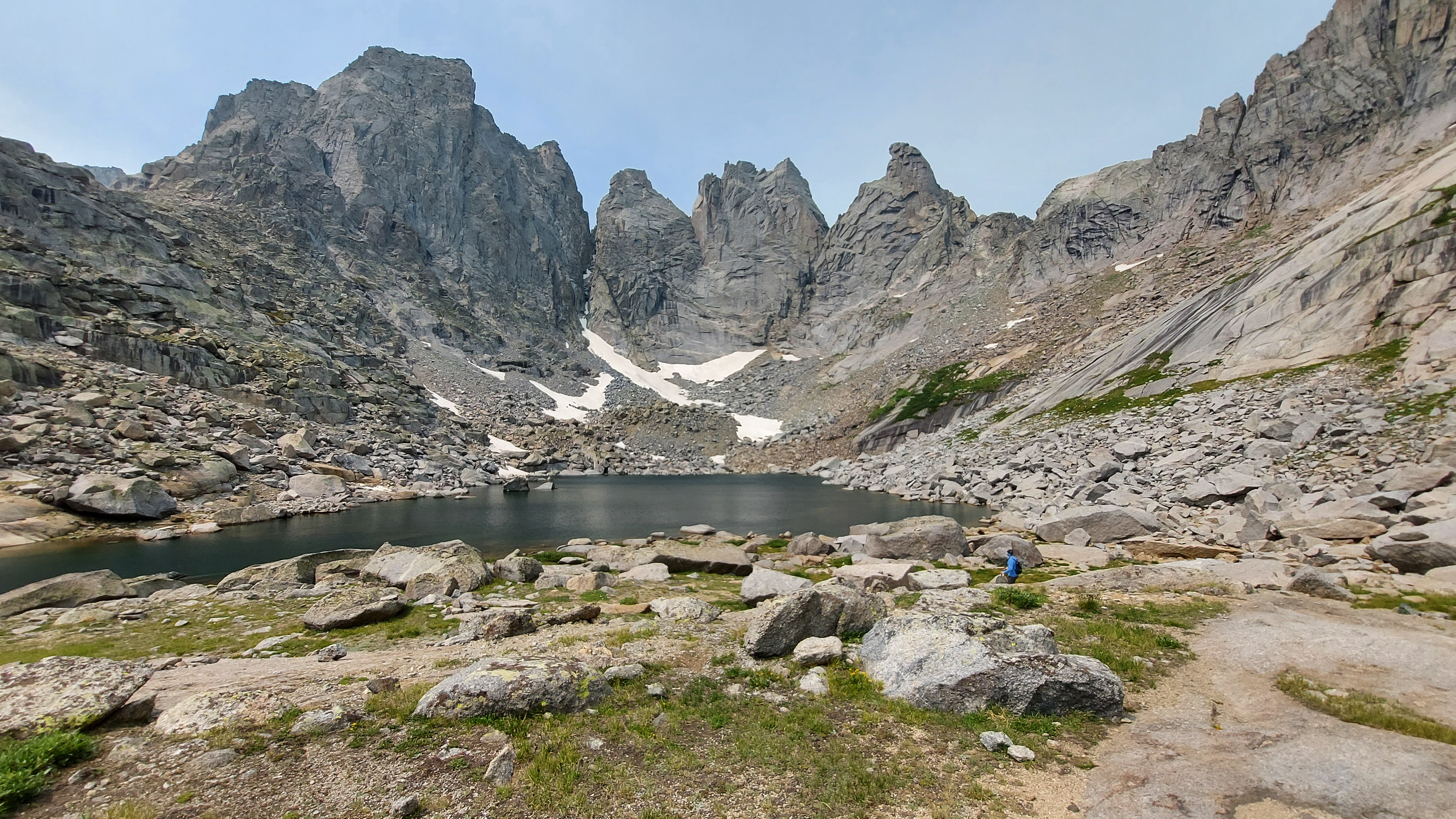
On day three, Bob, Rob, and I set out to bag Uncompahgre Peak. We climb along the creek, up through meadows of yellow and purple and white blooms, an open country trek upward as we circle the peak from northwest to southeast, where the main approach lies. Past the looming Matterhorn, up along sudden tan sands and lingering snow, on up the rolling green ramparts beneath the gothic cathedral spires and concave couloirs of Uncompahgre’s south face. A scramble up a harsh grade begets a long, steady ramp up past pikas and yet more flowers and ground set aside for endangered butterflies. Just shy of 14,000 feet, a wall requires some scrambling, but beyond that is a steady, limited-oxygen stroll to the top. From the summit we have a 360 panorama, sun here and storms there, our arrival just in time: distant thunder rumbles, Rob’s hair on his hand perks straight up as he stands astride the peak, and a few snowflakes start to wander down. Every manner of precipitation falls on our now urgent descent: the snowflakes, some sustained graupel, sleet, a little hail, and finally the rain, which picks up in earnest as we approach camp. When we look back up at Uncompahgre, its upper reaches have a light coating of snow. As day hikes go, this is one of the best I’ve ever done, the looming storm only enhancing the conquest of the summit.

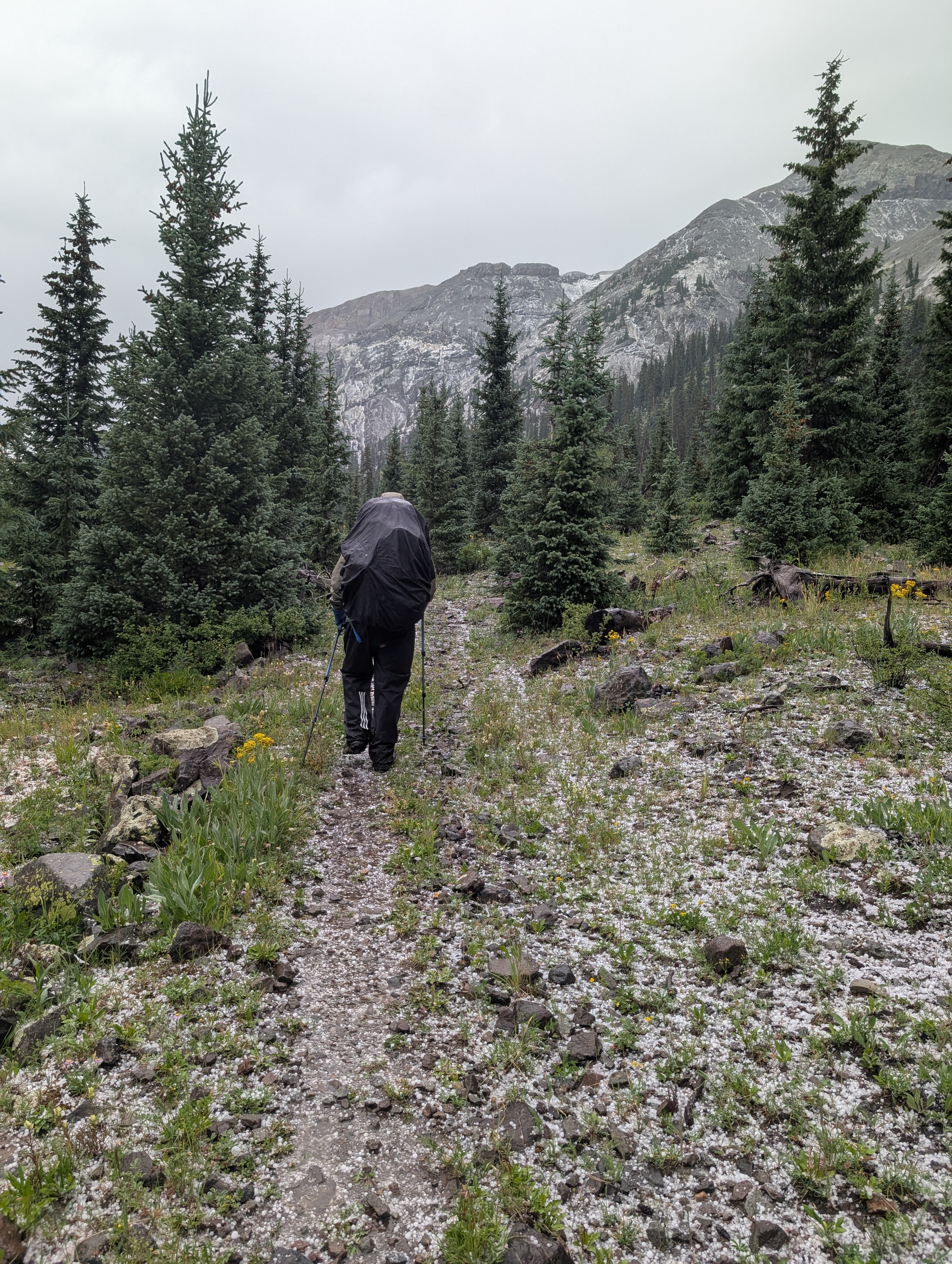
The fickle San Juans weather continues on the hike out on day four. Rain gear goes on and off all day as we descend the East Fork, a graceful vale that proceeds from high peaks to scree fields to avalanche-prone slopes of spruce to red towers reminiscent of Zion. Right at a shaky river crossing, however, comes the coup de grace: a sudden onslaught of hailstones, many as large as chickpeas, comes crashing down and sends us hustling for tree cover. After they have fallen the landscape is strewn with tiny white pellets, the walls to the east coated and glittering and the rutted path below us now a soupy mess of water and floating ice. This is not the least pleasant thing underfoot on the East Fork, however: that title goes to the cowpies, left by a lowing chorus of cattle that harmonizes as we walk by. At least we evaded the sheepdogs.

On the final evening we car camp off the Middle Fork, mission accomplished in spite of the absurd hail. Here we have the definition of Type Two Fun, a few minutes of misery that blossom into absurdist laughter and a memory that we can look back on forever, a random Friday on the first of August now immortalized, a remember when we did this, pushed out of comfort and saw a rare new beauty that will only pour gas on this blazing yearning for more of the world. The cattle go quiet and the creek rolls on and Rob and I stand out to watch the stars appear above our stand of aspen, musing on other yearnings we have.

Our two Ford Expedition rentals misbehave on the way back to Denver. The car alarm on Bob’s goes off three times in the night of our final evening, while the one I drive has the tire pressure light go on twice, growing worryingly low after dinner in Denver and prompting an early return. But it is a beautiful ride. We cruise along the Blue Mesa Reservoir, one of those manmade oases that dot the West, both a triumph over and a failure to fully tame nature. Lunch comes in Gunnison, with its bustling downtown, and we then ascend Monarch Pass back over the Continental Divide. The Arkansas River Valley and South Park would look like South Dakota but for the Collegiate Peaks and the backside of the Front Range looming over the high plain. We ascend once more, wind down the Platte Canyon, negotiate our way into Denver for the final night before heading out.

In some ways, Colorado has conquered America. The country vibe that has consumed pop culture this decade may get funneled through places like Nashville, but it has deeper roots in the cowboy west than the history-laden South. This is America as the open frontier, home to the pot-smoking libertine and the fitness-focused weekend warrior. But the frontier is over: after each weekend the chasers of peaks and slopes head back down the passes on I-70 and settle into the creature comforts of the subdivision on the outskirts, the escape to their safe retreats. Something is lost here but we don’t know quite what it is and so we yearn for it, nod to the past and chase a future. In this way, Denver and its environs may be the most American of all cities, spared the extremes of the coastal giants; as a newer city of many transplants, it lacks the particularity of other heartland metropolises, yet maintains a hold on reality absent in the likes of Las Vegas. There is a freshness and youth here, and I get the allure, an American reinvention that avoids the sterility or museumification of older societies. But while I feed off that youth, I need more than it.

My split personality gives me clues to what it misses. I crave communion, relish tapping into these ties old and new, and over the past several months a shared life has been taking shape through careful steps and weekend drives down I-35. And yet I demand solitude, reflexively rebel in contrarian ways, possess within me a deep instinct to disappear into mountains or at the very least drive off into some anonymous western town where no one knows me and where I can be something other than my staid, disciplined, ever so rational self. The constant in all these strains is a rootedness to the land, a spirituality of place that I find more and more at the core of my being, whether that is in ventures outward to new beauty or a return to the North Shore cradle that birthed my oldest friendships and more recent dreams. These landscapes tell the stories of who we are.

Porkies

The Upper Peninsula of Michigan is a land that fades gently into the wild. Culturally it has much in common with northern Minnesota, old mining and timber towns now enjoying the tourism burst of beautiful lakefronts, but it feels a step further from creature comforts, from big city money pouring north. Its towns are old, some them easing back into the woods, back into a Hemingway story and then out of time, like the ghost towns of the west but swallowed by maples and hemlocks and an undergrowth of ferns. These forests feel more capacious and less cloistered than the coniferous northern shores of Superior, less guarded in their secrets. The UP is an open book, no hidden agenda or ambitions: just some remote country surrounded by stunning lakes.

On an unseasonably warm September weekend, I head for the UP with my mom and her partner, Doug. Porcupine Mountains Wilderness State Park, or the Porkies, is Michigan’s largest state park, and it clings to the south shore of Lake Superior not far from the Wisconsin border. There are roads down all the splashing waterfalls on the Presque Isle River on the west end and to Union Bay and Lake of the Clouds on the east end, and a long loop around them to the south, but the vast majority of the park is a wilderness, accessible only by foot.

We are in the Porkies for a five-day backpacking trip, but that comes with an asterisk on day one. Cotten cabin sits a mile from the trailhead, tucked in an idyllic maple grove along the lakefront beside a small stream. It is rustic but newly built, large and with two bedrooms extending back off the large great room with a wood-burning fireplace and ample counter space to prepare our freeze-dried meals. Dinner comes at a picnic table down by the lake, and the sunset is stellar. Owls hoot out their persistent questions off in the distance, and the lake sloshes gently, constant but never quite uniform in its rhythms. I write by candlelight and drift into the night, easing into adventure.

The second night brings more of the same. The hike here is a long one, over twelve miles, and while there are regular rises and falls around creeks and ravines, it traces the lakeshore nearly the whole way. Campsites are wedged between a low ridge and the shore, with the trail winding up and down to meet them. Campsite LS-18 is an absolute jewel, tucked away from the trail in the halls of a maple grove that lets just the right amount of light filter through to keep it both inviting and cool. A long stony beach pulls us to the lake, and the seating around the fire ring features a few stone thrones. We could have stayed here for days.

On the third day we have the rare backpacking joy of a leisurely morning, a luxury more accessible in the Midwest than the West: the temperature change will be moderate, there is no threat of afternoon thunderstorms building in the mountains, and our next campsite is guaranteed. We are free to sit on the rocks, swing in a hammock, and read a bit more. The backpacker’s paradox, fleetingly achieved but delectable when it comes, when off the trail and all the camp chores are done: the bliss of nothing to do. It is hard to stop lounging in the looming heat.

When we do get moving, the trail promptly climbs upward past small windows of lake view through ridgeline scrub oak. It is a still day, the air growing sticky, and a road walk from a parking lot to the Lake of the Clouds overlook is momentarily jarring, with motorcycles rumbling by and blaring music. The crowd at the Porkies’ most famous point on a Friday in September does not exactly exude physical fitness, either, but they are here to take in the commanding view over lonely Lake of the Clouds, hemmed in by the Porkies on three sides and emptying down the long river valley of the Big Carp to the west.

We lose the crowd when we descend and set up camp on the south shore, just back from the water in a hemlock grove. The occasional motorcycle rumble echoes downward and eventually some people at the camper cabin on the opposite shore clunk around in canoes on the lake, but no one passes our site all day. Seven swans are a-swimming in the lake, or rather bobbing up and down, showing us their rears as the seek out food. Instead of the long sunset over Lake Superior of the past two nights, dark comes quickly here behind the ridgeline, and we are content to let the daylight dictate our evening.

On day four we clamber up to the overlooks, drink in the view, and enjoy the upper reaches of the Big Carp River Trail, which tracks the ridgeline between its namesake’s valley as it feeds down from Lake of the Clouds and then makes a right turn into Lake Superior. From there our path sinks through a thick hemlock forest, twice fords the Big Carp, and then tumbles past a series of cascades on the way to the lake. Our site tonight is just far enough from the mouth of the Big Carp back east to be annoying, and although it is well-situated on the lakeshore, it is a bit overused by sloppy campers.

Our final morning is an eighty-degree day, a strange mid-September occurrence that has us baking as we retrace steps back out toward the parking lot. Unseasonable weather aside, this has been a satisfying end to a summer of travel bookended by walks with both of my parents. (As my mom and I toured the Porkies, my dad was somewhere on the opposite side of Superior, undertaking the second half of the Superior Hiking Trail through-hike he began last fall.) It is the first time my mom and I have backpacked together, and while a few moments on this hike call back to her fondness of a childhood family hike at Sleeping Giant in Canada, we also fall back into memories of our earliest camping trips. Sometime very early on she and I camped in Beaver Creek Valley in southern Minnesota (all I remember is mud), and I vividly remember a visit to Rock Island off Door County in Wisconsin, in which I first surveyed the depths of a pit toilet and declared that I would withhold expelling any waste until we got home days later. Whatever form they take, these retreats into the woods are part of who we are.

Perhaps the greatest joy of this trip, however, comes from the logbook in Cotten cabin. Many of the entries are the typical rhapsodies of cabin visitors, but here, the younger authors have taken the genre to a new level. In a trend started by a 16-year-old Leah, many have illustrated their cast of characters for their weekend, with drawing of each actor’s head along with basic descriptors such as their ages or “my best friend” or “needs a haircut.” (In my contribution, our descriptors are “oldest,” “old,” and “younger, but increasingly old.”) There are rival perspectives from dueling siblings and artistic masterpieces devoted to the mice who apparently populate the cabin. (I also add an owl.) “50% annoying, 50% OK, 100% brother,” one kid judges his younger sibling; Ian, meanwhile, recounts how he made a figure out of candle wax that looks like something his mom will not let him name in writing, though the tadpole-like illustration does rather convey the point.

Where do all these gems go when the journal fills up, I wonder. I hope the parents have snapped pictures of a few of these ephemera, these jolts of life in a place and time, moments that can pierce through any forthcoming teenage moods or young adult anxieties. This is the beauty of the written word: to observe life and to leave a record of it, to write a history of what is good in one’s world: honest, insightful, good-natured even when frustrated, to take what might otherwise fade into vague memory and give it narrative form. Here is to all of those memories hikers can make when they head into worlds far from home and daily obligation, to the stories they write that they will forever carry with them, whether faithfully recorded in a logbook or stashed away in a corner of the mind. These journals show exactly why we do this.

WRT V, Part 2: Into the Towers

This is part two in a three-part series. Part one is here.

For a sixth straight year, I am off on a western hiking adventure of overpacked food, bourbon, deep debate, and dramatic scenery. Stalwarts including Uncle Bob, cousin Rob, and friends Amy and Ed are here once again. Our numbers have swelled this year, as van-dwelling cousin Alex and his wife Meghan have timed their meanderings of the American West to join us. Jim, too, is back for the first time in three years, making for perhaps the largest party in the history of this crew.

We gather at Big Sandy Lodge, a resort at the end of a long, car-killing road high in the foothills of the Wind River Range in west-central Wyoming. A collection of spare cabins arcs around an opening in the pine forest, and a small lake frames the view to the nearest peak. The small lodge serves up hearty communal dinners and welcomes in exhausted hikers, and the proprietors’ toddler pulls books from the shelves and insists that I read them. (The first one he hands me is in French.) We lay out our meals on the single table in one of the cabins for the annual debate over necessary supplies, and we later enjoy drinks by oil lamp. We are at the edge of civilization, a final homely house on the frontier.

Eight hikers set out from Big Sandy Lodge the next morning, but a mile in, Jim concedes that physical ailments will keep him from enjoying this trip, and he makes the difficult decision to turn back. Nurse Meghan escorts him, and Alex and I hang with her pack while the other four press on. When we are reunited, Meghan, Alex, and I turn on the jets to catch up, but in our haste choose not to look at a map at the first fork. We thus end up on a path parallel to the one we want, and we are two miles in and beyond some pleasant lakes and mountain views before we appreciate our error. A backpacking backtrack ensues, and our first day adds four extra miles. For a second year in a row, this alleged master of maps has seen his group get hopelessly lost just a mile in. I hereby forfeit my credentials back to the National Geographic Society.

The correct trail is closer to the spurs of the mountains, up rises and past parks with nascent creeks, down a busy trail to Dads Lake, where we finally catch the waiting group. The Winds, we can see here, are not a secret: plenty of families roll in on fishing trips, including a horde of loud kids on the bluff right above our eventual campsite on Marms Lake. But some passersby tell us there is solitude just a bit onward, and the first steps on day two are promising.

The second day has generally become the most aggressive of these trips, and this year is no different. The sheer exhaustion may not match the Colorado Trail’s offering two years ago, but this one may be the most technical. It starts out innocently enough, as we make our way up a valley with a glittering creek that bubbles downward and swing past a series of lakes with sandy beaches, tempting us to stop for a swim. Sheer alpine beauty. We rise above the trees, skirt the aptly named Barren Lake and swing up to Texas Lake, the source of the stream nestled deep in a small cirque. Harsh peaks line its sides, but up one scree field a few figures slowly climb. This is Texas Pass.

After a lunch break and ample incredulity over the path ahead, we make the slow plod up the 800-foot pass. Rob and I pick out the route up, call some guidance back downward. The adrenaline surges at the wind-blasted crest, and after some recovery we step forward into the Cirque of the Towers, the destination this trip, a beauty of a high-country bowl beneath stunning peaks and a haven for rock climbing virtuosos.

The Cirque’s serrated jaws wrap around Lonesome Lake, invisible in the depths below, and we traverse a small snow field and detour to an overlook above another stellar lake before we begin the descent. At first it is lovely, down rock ledges and past another dancing stream, to the point that we entertain camping up here before wisely choosing to plunge downward. This is a treacherous stretch of loose dirt and tentative footholds, less physically exhausting than the climb but perhaps more taxing, and the shores of Lonesome Lake can’t come quickly enough.

We make camp a quarter mile down the North Popo Agie River, Lonesome Lake’s outlet, amid some scrub where forest meets meadow. To the west, the Cirque, dominated by Pingora Peak just right of center, a striking granite pinnacle reminiscent of Devil’s Tower. Beyond it, a jagged ridgeline of rock-climbing conquests wraps southward to the sheer-faced massifs of Pylon, Warrior, and War Bonnet Peaks. To the east, a long run down the valley of the Popo Agie, peaks and cliffs lining the route and closing us in to the north and south. The last remnants of snow cling to the nooks where sheer faces meet boulder fields below, some of them permanent enough to count as glaciers.

We spend two nights on the doorstep of the Cirque. A day hike on day three takes us around Lonesome Lake and into the upper reaches of this great bowl, on and off a semi-formal trail past additional tucked-away camps and a curtain waterfall. One thousand feet higher up, past a labyrinthine boulder field, is a mini-cirque with its own little lake and walls up to the heavens. Atop the jagged Shark’s Tooth, we pick out two ant-sized climbers summiting the peak. When in shade some of the spires look ominous, the guardians of some dark lord’s land in a fantasy series, an otherworldly sinister beauty that has me thinking this may be our most stunning single destination on any one of these trips.

On day four I wake to a drip of water in the face, condensation seeping through the rain fly and dropping to touch the tent fabric. I step out and gaze up at the fog hanging over the Cirque, coming and going as it obscures peaks and slowly lifts. In moments like this nature kills any sense of time, just invites a steady gaze until the magic breaks. After breakfast we push up Jackass Pass, the tamer southern gateway to the Cirque, and bid its spires farewell. Arrowhead Lake poses a choice: either clamber back up a promontory and slide down a Texas Pass-type slope, or swing west along the lakeshore through a boulder field. In keeping with our theme of the trip, we choose the boulders, swinging across gaps, sitting to sink into a passageway or clambering to rise above the furtive crevasses.

Next is a long plunge down to North Lake, followed by yet another rock scramble. On a spire to the right, climbers work their way up a sheer face. Up the trail come all manner of hikers seeking the Cirque: backpackers with bold itineraries, young couples with climbing ropes, day trippers from Big Sandy Lake, teenage fishermen, and a bachelorette party of 11 in matching Wild Women of the Winds hats and their five dogs. One last big drop brings us to the tent-dotted shores of Big Sandy Lake, and we pick out a campsite atop a small rise over the lake where we polish off the bourbon and play cards deep into the night.

The final day of hiking is, after the past few days, an easy stroll downhill, though thick forests and the occasional pleasant meadow along the Big Sandy River keep it lively. It is easy, that is, until the final half mile. Over the course of this trip Rob’s CalTopo app has saved us at numerous crossroads where the paper maps fall short. This time, however, it outdoes itself, and we are left picking our way through a bevy of downed timber and over awkward rocky knobs. Juicy burgers and beer await at Big Sandy Lodge, however, and we unwind, reconnect with Jim, trade stories with three hikers who have been in deep over the past week. It has been another hiking triumph, another journey well-spent, and I head east again in full belief in the power of these wildernesses to take us to new heights.

Part 3 is here.

Longer Trails

“The absurdity of a life that may well end before one understands it does not relieve one of the duty (to that self which is inseparable from others) to live it through as bravely and as generously as possible.”

-Peter Matthiessen, The Snow Leopard

The last time I backpacked the Superior Hiking Trail, I found myself rather done with it. I’d reached the point where I’d knocked out the entire trail between Gooseberry Falls and Judge Magney State Parks, save for a nondescript inland portion north and west of Grand Marais. Every campsite featured a crowd of tents, solitude elusive and prospective companions a complete roll of the dice. (The current leaders in the clubhouse are the crew of twelve on the Beaver River who brought their volleyball along.) I will always have a soft spot for the SHT and will revisit many of its high points again and again, but there are many trails to hike, and I have gotten most of what I needed out of the SHT, excepting perhaps a through-hike that will likely have to wait for retirement.

Retirement, you say? Along comes my dad, happily sailing forth in that era of life, and he has indeed set out to hike the norther half of the SHT this fall. I am pressed into shuttle duty, and on a weekend in late September help maneuver the logistics of a several-week expedition. We head for the far northern end off the Arrowhead Trail and stroll the short distance to the trail’s terminus at 270 Degree Overlook above the Pigeon River and the Canadian border. We have nailed peak fall colors here in the far northeast corner of Minnesota, and the weather this weekend, though grey and at times ominous, never unleashes the sort of rainfall that would bog down a hiker. The bugs are few and far between, though of course the lone mosquito at our site on the second night finds its way into my tent.

I am here as support. We perform a series of maneuvers, with me backtracking and moving my car to allow my dad to proceed with a lightened load through certain stretches on his steady march south. We plow through the forest between trail’s end and Andy Lake Road, its renaissance under way after logging some fifteen years ago. We push up Rosebush Ridge, host to the highest point on the entire SHT; the view is nondescript, but the maple forest in peak fall form is its own front-line attraction. Further south, the Hellacious Overlook, though much further inland than most SHT vistas, gazes down upon across beaver ponds and golden fall trees toward Lake Superior, and we squint at the lumpy blobs on the horizon, unsure if one of those clouds is Isle Royale. Even inland from its usual lake-lining ridges, the trail offers up its customary beauty.

These less traveled portions of the trail still feature a steady stream of people, and sometimes that companionship leaves something to be desired, as in the case of the young man who occupies the Hellacious Overlook to fly his drone, the name of these aerial intrusions never feeling more apt than it does when it intrudes on the final push up this mount. But for the most part, fellow SHT venturers are good company. Further along the dome at Hellacious we meet two Asian-Americans from the Twin Cities, out on their first hiking venture and gushing at the opportunity this new experience creates. At Andy Creek we share a campsite with Andy, a cousin of my seventh-grade science teacher; his frenetic pace up and down the trail matches his scattershot conversation and bear vault packing efforts. After a week on the trail said vault somehow still overflows with every backpacking food imaginable. At Caribou Pond we meet Ben and Hadey, a couple around my age on their first backcountry venture together, though both know a thing or two about the outdoors. They come to the rescue when my bourbon flask suffers an unfortunate incident and adds distinct new flavors to the contents of my bear vault.

Still, the SHT is wilder here than at points further south. In places the brush grows thick along the trail and the infrastructure could use some Biden bucks, with a profusion of tippy bridges and misaligned boardwalks. Less use means this stretch is spared the man-eating mud patches encountered at points further south, in spite of recent rains; aside from the obvious overlooks, my favorite stretch is a boardwalk-covered cedar swamp where I spend a good 20 minutes in contemplative silence as I await my dad’s arrival from the opposite direction. I realize how little time I’ve taken to do this lately.

The deep breaths beneath the cedars are a valuable reminder to maintain my pace on my own terms. This fall and winter will be a pause between an adventure-filled summer and a spring of 2024 that may put all previous travel to shame. I am that eager adventurer, yes, but I am also someone with defined Duluth winter cycles, a steady rhythm that can be my self-assured answer when life is more than a rattled-off list of the places I’ve been. Over these past few years I’ve achieved a new speed more in line with my ambitions, and yet I value this time to modulate, reined in and able to sit and read and write and think, and set a pace that matches the moment.

At Cariou Pond after the second night on the trail, I turn my dad loose. He heads south while I pick my way back across a beaver dam, back past a cloud-shrouded Hellacious Overlook to my car on Jackson Lake Road. The ride south on 61 is a slog through increasing traffic and fog, but any delay is inconsequential. This is what an autumn should look like: brilliant and yet portentous, darkness coming early but moderated by stark moonlight, a few final warm nights before the heavier sleeping bags come out.

Unlike me, my dad does not hike with pen and paper (or their digital analogues) with which to make sense of everything he sees; he simply brings a copy of The Snow Leopard, his guide on this and many other journeys. I have, through him, come to adore this little book as well. I could here unspool my thoughts on that bench in the cedar swamp into some greater personal meditation, but that might, I think, miss the lesson of the book. In the story of this weekend I am the supporting cast, grand plans on hold as a man sets off purposefully down a trail to the next phase of life. It is a role I am happy to play, and one all of us should from time to time, our authorship intact but bounded by our reality as social beings. My own next surge awaits. For now, my dad walks south, and I simply admire his freedom.

Into the Western Well

It is August. After a social spring and summer, it is time for my annual retreat to a wilderness in the West. Bob, Rob, Amy, Ed, and I are ready to disappear into the mountains yet again. It is my fifth time joining this group on its yearly venture, and this time around I saddle the group with an itinerary in a new mountain range I’d seen from a distance and deemed worth exploring. We are off to the Cloud Peak Wilderness in the Bighorn Mountains of Wyoming.

The Bighorns stand to the east of the Rockies as a lonely outpost of high elevation, a prominent range separated from others by twin vast open expanses, the Absarokas by the Bighorn Basin to the west and the Black Hills by the Powder River Basin to the east. They sit far from any other major attraction, save perhaps a road tripper’s route to Yellowstone and the Tetons and the Little Bighorn battlefield. The two gateway towns, Sheridan and Buffalo, combine for about 20,000 residents (granted, a veritable metropolis by Wyoming standards) and little of the seasonal surge in population that descends on other high country access points we’ve visited in the past, such as Red Lodge in Montana or Leadville in Colorado. They feature no national park or monument, no 14,000-foot peaks, no iconic roadside attraction to lure in the I-90 road trippers, many of whom may now even take the Google Maps-endorsed bypass on US 212 from Spearfish to Crow Agency, thereby avoiding Bighorn country entirely. For that matter, the range’s namesake sheep, decimated by early white settlers, have only been reintroduced in one northern pocket of the mountain chain.

What the Bighorns are is a rougher edge of wilderness. Here we find more extreme weather, more creek crossings, more horse poop, and bigger boulder fields than we have seen elsewhere. We find both solitude and trails more traveled, and a smorgasbord of Western experience, from rough frontier edges to the encroachment of coastal cosmopolitan comfort, from wide open freedom to the memory of loss that lingers in places like the Crow Reservation we drive through on the way to the trailhead. These rocky slopes provide everything a good hike should.

The hike goes awry quickly. After a leisurely stroll from the Hunter Trailhead on a rough road used by horses and ATVs, we take the alleged scenic route on the Ditch Trail, whose name alone should have been a warning. It starts out clear but muddy, tracking a flume-like creek running down from the mountains, but after we cross it, we promptly lose the trail and end up whacking through a dense thicket of 20- to 30-year-old pines as it begins to rain and hail. GPS gets us back on the putative path, but it clearly had not been maintained in years, as we are left to circumnavigate thousands of down trees and miserable swamps that afflict the occasionally visible ditch that give the trail its name. We are lucky this is day one and we have the energy for this slog.

Once we get back another horse and ATV road, we can finally cook along through mid-altitude forests and across alpine meadows, past the graves of a few lonely frontiersmen and through variable precipitation before we land at a respectable campsite near a creek crossing. It clears up enough to enjoy the evening, and a large moose cow wanders by after dinner. Day two is day of creek crossings as we head higher up Florence Pass, a steady push upward with pauses to step gingerly through frigid waters. The rain and hail hits on an exposed stretch of rocky trail above 10,000 feet, and we take shelter in a cave just large enough for the five of us, where we wait out the worst of the storm and eat lunch. Rob’s garbage bag turned pack cover blows off down the canyon, Amy is quite done with creek crossings, and when we get to Florence Lake, our planned destination for the evening, we discover a rock-strewn, barren shoreline with near zero flat ground to pitch a tent.

Not enthusiastic to go any further, we scope out some halfway acceptable tent pads up a slope from the lake and make camp. Despite its obvious deficiencies, Florence Lake is a beautiful place to settle: stellar waterfalls tumble into the pristine waters, and the mountains glow golden at dusk as the sun finally emerges from the clouds. Across the lake are the wide arms of Bomber Mountain, on whose slopes a World War II era warplane’s remains lie; behind us is Florence Pass, the high point of our hike at 11,000 feet, and a commanding view of the lakes down the next valley is just a short stroll away. It is a chill night, frost on the tents and pack covers in the morning, and the need to thaw it all out becomes our excuse for our usual slow exit from camp.

On day three we descend from Florence Pass along a series of lakes before we come to the busier corridor that links the West Tensleep Trailhead (our exit point) with Mistymoon Lake and the trail up Cloud Peak. We have found the open high country at the heart of the Bighorns, and finally, the weather cooperates and gives us free sightlines of rocky peaks and tangled heath and a series of brilliant lakes. A giant bull moose hugs the shoreline of Mistymoon, and we score a prime campsite at the base of a base of a waterfall in a valley that serves as a staging bowl for assaults on Cloud Peak. All trails in the southern Bighorns seem to lead to this small stretch, and for good reason.

After two days of solitude, we know we’re in for a different experience when we encounter a herd of horsemen all conspicuously packing heat. On our other hikes, most of the people we encounter are typecast backpackers: young adventurers, veteran wilderness explorers, people who seem born to be part of nature. In the Bighorns, we find much a greater variety: a lot of families, some salt of the earth locals, a general excess of cowboy hats, and in one case a kid hiking in cowboy boots. We admire the dad from New Mexico with his three backpack-toting kids, ages nine, six, and five, all cheerily bearing their loads and off on fishing excursions in the alpine lakes. The fellow travelers we get to know best are Brandi, a Wyoming native whose parents have finally accepted her itinerant lifestyle, and Oliver, her Salvadoran partner with roots in Brittany. They met when Brandi signed up to crew Oliver’s sailboat in Grenada and they have since traded sailing for the van life, which has now led them to the Cloud Peak Wilderness. We share a site with them for a night, and suddenly we are discussing sailing and Salvadoran politics and migration and gang violence over our respective freeze-dried and packaged delicacies.

On day four, Bob, Amy, and Ed take it easy with a day hike to Solitude Lake, while Rob and I wait out a thunderstorm before we tackle Cloud Peak, the highest point in the Bighorns. While its summit at 13,171 feet doesn’t rival the Rockies’ fourteeners, this push upward is substantially harder than our conquest of Colorado’s Mount Massive a year ago. Part of it is a route problem: several people we chat with and a guide I’d read suggested that, on the way up, we should cling to the ridge on the right. This advice, in the words of a Scandinavian man we chat with high on the saddle who’d followed the same guidance, is “moronic shit.” It results in an extra hour of bouldering instead of a fairly straightforward surge up along a creek and an easy runoff ramp, albeit with some impressive views.

Even so, the bouldering is inevitable over the last 1,500 feet of the climb, up through crags and around crevasses and past the few snow fields that linger late into August. We summit around 2:30 PM, blasted by winds gusting up to 50 miles per hour, and begin the steady rock hop down. The slopes are relatively empty: besides Rob and I, the climbers on this day include the Scandinavian man and his Asian wife (plus their teenage son, who bails at the saddle), Brandi and Oliver, a family with a dog who make the whole affair look like a walk in the park, and three similarly sprightly young men, their footwork as they dance from boulder to boulder leaving me in awe. On the way back we cruise down the ramp but are still left with some rough scrambles as we sort our way through the haphazard cairns marking the route.

After a second night at the foot of Cloud Peak, we hike the eight miles out down West Tensleep Creek. The first half is a scenic stride past three lakes shimmering in the sun, but the final four miles are more of a slog through woods and mud, though they are livened up by an ongoing game of tortoise and hare we play with a group of teenagers and their handlers. Their antics at a final crowded stream crossing leave Bob and Ed, longtime guides of boy scouts on camping excursions, reliving old dramas. Finally we stumble out to a crowded trailhead, back to civilization and backlogged emails and requests for my takes on a shocker in Duluth’s mayoral primary.

We begin and end our journey in Billings, home to the nearest airport of substance. It is a regional center; on an east-west axis, it is the largest thing between Fargo and Spokane, and the spot where two major cross-country interstates meet. This status gives it some good institutions for a hub of its size, a crossroads of industry whose main draw is its proximity to other things. In my previous three visits I saw it only as a launch point, but as we spend some time here this time around, its culinary scene throws in some genuine surprise. Juliano’s, a converted old home with a Hawaiian chef, is one of those small city strivers ahead of its curve, brilliant but underappreciated. The Granary, in spite of its barnlike structure, provides a little window into Mediterranean basin fine dining. As a fervent defender of Billings-size cities, I applaud the progress here on the western edge of the Great Plains, though I am sure a few locals can only shake their heads.

I think back to three years ago, when I first drove these open roads around Billings. It was deep in the Covid summer of 2020, and the West felt like the land of restless freedom and sorrow that has formed its myth. This time, we debate several forms of life on display here. There is the gun-toting machismo, most charitably viewed as an extension of a brave frontier ethos and a can’t-be-too-safe caution in a land where crime is rare. On the flip side is a fetishistic continuation of a lone wolf myth, to say nothing of the solitary lives ended late on lonely nights on the prairie. (Wyoming has the dubious distinction of the nation’s highest suicide rate five years running, with Montana right behind. The correlation between firearms and the completion of a choice not to be is not hard to see.) And then it will always attract the Brandis and Olivers too, the free spirits who find, in its vast open spaces and its growing subcultures, a place where they can live cheaply and freed from societal constraints, at liberty to roam and shed obligations to the past. Is their way of life a bold pursuit, or a frivolous retreat from the commitments that give a life meaning? Opinions differ among the five of us, all urbanites with comfortable careers who make an annual escape; time may also render such questions moot. For now, the West accommodates them all, and at its best gives families like our New Mexican friends a playground to raise kids to explore and achieve away from the monotony of overprotection and screen life.

For us, however, it is just a snippet, a taste of the wilderness that can carry us through for another year. Before next time I have new gear to buy and routes to plan, and after a summer with a lot of time on the road, I am ready to settle back in to Minnesota life for a spell, too. Until then, the West will linger there for us, that allure eternal.

Grand Staircase III: Layers of Time

This is the third in a three-part series. Part 1 | Part 2

Sated by my time in Grand Staircase-Escalante, I drive the three hours back to Zion, where I nestle in at the Novel House Inn in Springdale, a mile’s stroll from the park’s gates. This writer is a sucker for this bed and breakfast, complete with sprawling library and author-themed rooms. I am in the Mark Twain Room, wedged between Walt Whitman and Louis L’Amour on the first floor, and the great red cliffs peek out above some trees through my window. There is a voucher for breakfast at a Mexican place up the block, a tray of cookies and lemonade in the afternoon, an attentive Irish proprietor, and a library where I can sit and organize my notes in the evening. What more could I ask for to round out this trip?

I spend the night at the Zion Brewery, which is, brilliantly, the first establishment one encounters when exiting the park via its pedestrian bridge over the Virgin into Springdale. I settle in at the bar and make a few temporary friends as we throw back beers. “Have these trips ever changed your life?” asks Russell from Philadelphia when I tell him the tale of my journey. Check back in with me later, I reply. A couple from Long Island then joins us, the husband glued to the North Carolina-Duke Final Four game on the TV, and I become a temporary Tar Heel fan at his behest. These are the best nights of solo travel, the momentary community a necessary counterpoint to the solitude of nights in tents.

On my final full day, I hike the full eight miles up Zion Canyon to the end of the road. At times I am on formal trails such as the Pa’rus across the meadows north of the Visitor Center, or the Kayenta between the Emerald Pools and the West Rim trailhead; at times I am on a semi-formal sandy track lining the river; and for long stretches I am just on the road, which is empty aside from shuttles every few minutes, the occasional car headed to the Lodge, and a steady string of cyclists. While the shuttle system has the effect of choking up certain spots when it disgorges busloads at certain popular locations, it means that vast amounts of the canyon, despite the number of visitors it hosts, are basically empty. Even in the four days since my backpacking excursion, the canyon seems lusher with spring, the cottonwoods’ leaves unfurling and purple and red and yellow flowers springing up here and there. I see a condor and a crane and a wild turkey, and at times the only sound is the rushing water of the Virgin River, which echoes off the canyon side walls. Never has a stroll up a road felt like such complete immersion.

After a quick recharge at the Novel House, I go for my final Zion hike: a quick burst up and down the Watchman Trail, which rises from the Visitor’s Center some 360 feet to views over Springdale, the campgrounds, and up the canyon. As on the West Rim, I half expect to find a shrine at the top, but instead it features verdant greenery crawling out of the rich red rock, a perfectly acceptable endpoint for a pilgrim to Zion. I sit for a while at the summit, process a few thoughts, make peace with the paths I’ve trodden over the past week. I read a passage I copied down from Leave only Footprints, a memoir by Conor Knighton, who visited all of the national parks in a meandering, yearlong post-breakup journey. Here, he contemplates a fireplace at the Grand Canyon that serves as a model for all its layers of rock:

Looking at a canyon’s different lines and layers, we can read its diary, seeing the various strata that made it what it is today. The layers are stripes, not smears; they all seem so clearly delineated. I wondered if, inside of each of us, those same markers exist. When we think of personality, we tend to think of it like a soup, a blend of traits and experiences that have been mixed together to make us the people we are today. Over the years, more and more gets added; the broth gets thicker, and the individual ingredients become harder to discern. It seemed to me that we might be more like that fireplace; like the canyon, full of layers with clear dividing lines; moments that say, from this point on, everything will be different. Maybe those lines mark deaths, births, loves, and losses, the moments we’d expect to define the different periods of our lives. Or, maybe they correspond to days and events we would have never initially seen as important.

Did I actually change as a person when I graduated from college? Probably not. Maybe a more significant shift happened midway through seventh grade, when my teacher told us to pick a college to do a report on, and instead of picking one that was good at sports, I chose Yale, a place I knew nothing about. Maybe your life changes on your wedding day, but I’d imagine the actual change happens on your fourth date, when the woman who will one day be your wife tells you a joke that somehow tells you she’s the one. It’s never clear a layer is over until the line appears and a new one starts. Looking past the fireplace, out to the canyon it represented, I began to think that I might be smack dab in the middle of an important layer, an era that was changing who I was as a person. There was the me before the parks, and there will be the me after them.

I ponder some of the layers in my own life, some obvious to any who know me and others more subtle. I was eight when I learned that the world could steal away life in an arbitrary instant, and eighteen when I learned it would be impossible to ever truly go home. At twenty-two I grounded a life that was somewhat adrift in a place, but by twenty-eight I found myself more in tune with the kid who had once run away from that place than the one who’d made a commitment to a thing that cannot love him back.

The world is forever changing, and that there is a sweet spot of knowing it will change you while knowing that you can also change parts of it. At twenty and twenty-one I began to sow the seeds of a worldview that understood this fact. Around twenty-six I internalized the power of forgiveness and began to appreciate that I did not need to define myself by the things I had lost. At twenty-seven and twenty-eight I undertook a writing project to interrogate these possibilities, and to play out the tension between competing strains of thought in my head. At twenty-nine and thirty I learned that more than a place I was in need of a pace, and have, perhaps, at thirty-one and thirty-two, found it.

In the four years since I last came to Zion I have hiked relentlessly forward in the fog, through a snow patch of work life upheaval and a climb up into a new Duluth network and on through the sticking mud of a two-year pandemic. It has been a relentless, and generally successful, but often very solitary phase. My navigation skills in any moment haven’t really been in doubt, but the view has not always been clear. Now, at long last, I think I can see again, and am even more eager to see where I am the next time I make my way to this canyon that has become my Eden.

In a few conversations before I left for the Grand Staircase, I described this venture as a last great solo trip, at least for the foreseeable future. This usually brought about a lament in response. Why stop now? I seem to love it, and I am good at it. But too much of my life has been caught up in a confusion between being good at things and therefore believing these are the things I must do. This doesn’t mean I won’t ever travel this way again, and I had some motivations for making this a solitary burst. But I have done what I set out to do, and I have came home content.

In these canyons there are always more layers, greater and greater depths and heights to explore. Some of it will be forever buried, and that is alright. But there are many more layers to discover, and next time I head forth, I don’t plan to do so alone.

Grand Staircase II: Stairway into the Unknown

This is Part 2 of a three-part travel series. Part 1 is here.

My night outside Zion is fitful, nervous, eager with anticipation, the sense that my plan for the next two days is no casual stroll. I have a one-night date with the West Rim Trail. When I go to collect my permit, the ranger appraises me carefully: this hike is a 3,000-foot climb, the upper reaches of the ascent are covered in snow, up top the trails are thick with mud, the only water source there is probably snow-covered, and oh, have you noticed all the rain in the forecast? I assure her I am a northern Minnesotan, and when she learns I’ve day hiked to three-quarters of the route before, she gains a bit more confidence in my abilities. The day dawns a dreary grey, which only makes for perfect hiking weather. A couple with overnight packs is also on my shuttle up the canyon, and we leapfrog our way all the way up to Cabin Spring, where they settle in at the first campsite on Zion’s roof.

This trek is one of phases. The first 2.5 miles follow the well-worn route to Angels Landing, the iconic clamber up chains between thousand-foot drop-offs that I conquered four years ago and feel zero compulsion to climb again. After Angels Landing is my favorite part of the whole trek, as the crowds thin out and the trail climbs a series of shelves with views to rival those of the famed promontory, culminating in a huge, white dome. From there, it tucks in along the backside of one of the mounts lining the canyon, past cool streams of snowmelt trickling down the rock. Higher up, the snow begins, first as little clumps alongside the trail, and later covering substantial portions of the trail itself, though it is firm enough and well-enough worn that at no point is it awful. At the top of the snow I encounter a family I’d seen high up on the East Rim the previous day, and their intrepid 10-year-old daughter advises me on how best to have fun with the snow. My kingdom for children who someday show the same pluck and guile as her. From here, there are more exposed switchbacks up another steep wall to the West Rim Lookout at Cabin Spring, where most day hikers (including myself four years ago) turn around.

I see no one in my 24 hours beyond Cabin Spring. There are more climbs, but they are gradual, and the muck is indeed treacherous in places, first as an insidious yellow mud that isn’t thick but clings to boots like leeches on legs, and later in a thicker, gloppy ascent with a full-blown stream running down the middle. The views are stellar, or so I am forced to guess: I am in the clouds, the chances to see outward sporadic, and while the mesa here is exposed enough that most snow is off the trail, it still clings to shaded hillsides. The late winter landscape takes on a haunted, empty air, and phantom voices carry through the howling wind. I am as alone as I’ve ever been.

Finally, I arrive at campsite 5, which sits atop a ridge between Phantom Valley to the west and Telephone and Imlay Canyons to the east. The clouds whip directly over me and plunge my ridge into obscurity, and I pass the afternoon cycling from one side to the other, admiring the vista in whichever direction has the higher clouds at that moment. I don’t tire of it. In time, though, the thicker clouds get too close, and rain, interspersed with ice pellets, begins to fall. I have a tent malfunction, but some string and some rocks solve my dilemma and keep me dry through a 12-hour span under the covers. I sleep poorly, never warm but never exactly cold, yet somehow content that I have made it where I want to be. I rise at sunrise and finally look out to see the view from my throne atop Zion. The world glitters beneath me, ignited by a fiery glow. I am transfixed, my pilgrimage at its apex.

I wait until nearly ten to break camp so the sun can eat away at the ice on my equipment and dry out as much as it can. The trek down reveals all the views I’d missed the day before, made somehow more stunning by their temporary withholding, and I plow down in an hour less time than it took me to make the climb. Beyond the snowy bits I join a day-hiking couple from Beaver Bay, just an hour north of Duluth; we trade shared acquaintances as we go. Angels Landing is an absolute zoo, and I may have seen it at its absolute worst: in just two days, the National Park Service is finally imposing a permit system on the famed hike, and only the select, pre-scheduled few will be able to head up the chains. I fight the crowds down the switchbacks and settle for a half-mile stroll along the canyon bottom back to the Zion Lodge for a much-needed meal and a drink.

The Lodge is not quite what the doctor ordered for a weary hiker. The food has all the flavor of a McDonalds with none of the speed. There is only one beer on tap until the distributor’s truck arrives again, though at least it is a decent local microbrew. There are no open tables and alcohol is not allowed off the patio on to the inviting lawn, so I decamp on a wall by the beer stand until a departing couple takes pity on me. I pay it forward and let a couple from St. Louis join me, and we bond over our fondness for road trips and incredulity over the crowds. (Shouldn’t all these children be in school?!) I share my shuttle back down the canyon with a clump of high schoolers on some sort of Christian retreat, all of whom ignore the mask mandate and talk earnestly about what they are looking for in relationships. Is it bad that my instinct is to buy them a case of beer?

I return to my car and climb back up out of Zion, back through the Mount Carmel tunnel and then north on US-89. My abode for the next two nights is a no-frills roadside cabin some 20 miles west of Bryce Canyon, and my dinner that night comes at a family diner in the town of Panguich, a bustling joint staffed almost entirely by teenagers. From my spot at the bar, I get a front row seat to the chaos, as the POS system is deemed a POS and three orders come out for tables with no one sitting at them. At least the wings are tasty.

A poll of acquaintances who have visited both Zion and Bryce has been inconclusive on which is better. While Bryce cannot match the sheer scale of Zion, it has an intimacy to it, and its famed hoodoos never cease to amaze with their wild shapes. Trails chart labyrinthine courses around the pinnacles of rock, never flat as they wind down to the floor of the canyon and then back up and around to get over to the next feature. South of the bustling amphitheater, a 17-mile road snakes its way up past 9,000 feet in elevation, with repeated overlooks up and down the Grand Staircase and across the Paria River valley. It’s snowing when I arrive, and while it is a bit too warm for anything to accumulate, three more squalls break out over the course of the day. The most eventful one comes as I traverse the Bristlecone Trail at the far end of the scenic drive; the woman I am following loses the trail entirely for a spell. She is one of five lost people I help over the course of the day, and I can’t pass up the opportunity to lament the decline of navigational skills. “Trust me, I don’t get lost!” I want to yell at the dude making his second circuit of the Peek-a-Boo Trail even though he is sure he isn’t; later in the day, we meet at an overlook and he concedes defeat. Don’t mess with my geography skills.

The burst of wind and snow that nearly stole my hat away atop Bryce Point tells me it’s time to wrap things up here. I wrap up my Bryce hiking with a quick trot to an ice-filled cave off Highway 12, where dripping water produces a trickling symphony that silences the cluster of viewers. I am glad I saw Bryce, but in a day, I feel like I have seen what it has to offer, while after nearly a week in Zion across two trips, I still haven’t touched its northern unit or The Narrows or Observation Point or its little-known southern desert. I conclude my tour of Bryce with a geology lesson in the visitor center, content with a rock-filled day sandwiched between two experiences of wilderness sublime.

This entire trip is, in effect, a traverse of the Grand Staircase, a series of rock layers that rise up from the Grand Canyon and the Colorado River into central Utah. These different bands of geological time give the rocks different hues, often ending in dramatic dropping shelves. Closest to the Colorado are the Chocolate Cliffs, while the Vermilion Cliffs rise near Kanab, just south of the Utah-Arizona state line, and include the Coral Pink Sand Dunes, the areas around Colorado City, and the lower layers of Zion. Next come the White Cliffs, which look like a jagged scrape on an aerial image; they form Zion’s upper reaches. The drive from Zion to Bryce follows the cut of the Sevier River up through the Grey Cliffs, and finally, at the top, are the Pink Cliffs that reach the heights of Bryce at 9,000 feet. Above these sit the great upland plateaus of south-central Utah, themselves rising in steps: the Markagunt, the Paunsaugunt, and the Aquarius. The Staircase’s eastern railing is the Kaiparowits Plateau, which stretches down from the Aquarius to the Colorado and falls off on its own eastern side from the Straight Cliffs into the canyonlands of the Escalante River. It is in this remote land, the last portion of the lower 48 states to be mapped by the US government, that I will spend the bulk of the next two days.

The drive east from Bryce has the distinct feeling of heading deeper into the wilderness. I tumble down from the Paunsaugunt through a series of Mormon frontier towns in the Paria River valley, oasis outposts with verdant fruit trees clustering around dust-choked homes. The road winds up into the Kaipirowits and down through funky Escalante, traffic thinned to a trickle. My eagerness at this fresh landscape grows, but nothing quite prepares for the Head of the Rocks Overlook, where the scrubby plateau disappears and the rocky canyonlands of the Escalante River undulate out in all directions below, the ribbon of the CCC-built Highway 12 the only thing interrupting the march of these rocky waves out to a few snow-capped ranges on the fringes of the wilderness.

At the direction of a ranger, I head straight for the Calf Creek Campground and claim one of the 13 sites nestled just above that small stream’s confluence with the Escalante. I wish I could have arrived just two weeks later to see this small Eden at its best, but as it is, these oases in the desert are budding and coming to life. I plug up the creek some three miles to Lower Calf Creek Falls, a 120-foot plunge of water into a deep, cold pool. The route is gradual, with views to ancient pictographs and granaries up on cliffs, and while a healthy crowd hikes this trail, it has nothing on Zion or Bryce. I dip my feet in the icy waters and take my time to soak in the warmth on the stroll back.

After a recovery spell in a hammock, I drive north into Boulder. On the way, Highway 12 skirts high above Calf Creek and the canyonlands to the east, an Angels Landing for cars atop the ridge, and then plunges into Boulder, the last town in the US to have mule-delivered mail, accessible only by unpaved road until the 1980s. The Burr Trail, an old cattle route, swings east from here, and a cheery sign announces a mere 72-mile trip to the Lake Powell Ferry. The trek would take hours; I settle for a trip in to the aptly named Long Canyon, a deep red gash in the stone, and home to a lonely slot canyon worthy of a quick exploration. That night, back at Calf Creek, I hop up on a natural red rock seat, sip away at some wine, and drift into a reverie as the stars emerge, deep in this lonely desert, the crackling fires and stray laughs across the campground filling me with a warmth independent of the cool evening air.

Some ice forms in the water bottle I leave out on the picnic table, but I have my soundest night of sleep in a tent on this trip. After packing up, I do a 6-mile stroll up and down the Escalante, wading its frigid waters 14 times as I process up the canyon to a natural bridge and an arch. The trail snakes along those pure flowing waters, up and down ledges and across dry washes, nestling beneath cliffs and cottonwoods and through fields of sage. All is at peace.

I take my time in making my exit from Grand Staircase-Escalante. First, another hiker mentions some unadvertised petroglyphs just above the parking lot by the river where I’ve been hiking, so I head up the trail opposite the river and, after a few false turns, arrive at these signs from the past. On the other side of the river, I pause for a scrumptious lunch at the Kiva Koffeeshop, a new agey wonder built right into the hill, with views up and down the canyon. Grand Staircase-Escalante is a beauty, Zion’s essence distilled to its basics and stripped of its crowds. I shall return.

Part 3 is here.

A Quest for Moose

Up until this past weekend, I had seen two moose up close in the wild. One was a tame sighting from a canoe; the other, which wandered in front of the family car during a nighttime drive down the Gunflint Trail when I was young, may have been the closest I have ever come to death. This docile creature, seemingly part deer and part cow, has otherwise been an elusive presence for a resident of northern Minnesota. While a quest for moose is hardly a search for snow leopards in the Himalaya, they are part of the local allure, and a trip to Isle Royale seemed the perfect way to rectify this lack of large, furry, antlered beasts.

Isle Royale is the largest island in Lake Superior. It sits some 20 miles off the coast of Minnesota and Canada, though it is a part of Michigan, leading those who come from the Minnesota entry to eternal time zone confusion. It is the least visited national park in the United States outside of Alaska. Over the past century it has gained some fame for its moose and wolf populations, which often move in relation to one another, though lately the wolves have preferred to wander off across the ice pack in winters and thrown the balance out of whack. The island’s folded rock is the geological twin of Michigan’s Keweenaw Peninsula, its length scarred by the glaciers that formed Lake Superior and created the lake-studded Northwoods that I call home.

After a year in which I kept up my travel pace largely by sacrificing companionship, I am eager to tread trails with other people. My fellow hikers, Connor and Alex, are new to backpacking but well-prepared for this venture. (We are all planners, after all.) Rarely have I been the experienced hand on my group hiking excursions, but as I relate tales of past excursions as part of the steady chatter that takes our minds off our feet, I realize just how much exploration I’ve done in my life. And though I’ve never been to Isle Royale before, it feels like home turf. When my companions, both St. Paul residents, ask me on the drive up if Lake Superior ever gets old, the answer is an easy ‘no.’ This realm is my playground, and these outdoor pursuits are among my fondest pastimes.

The ferry dock for boats to Isle Royale is in Grand Portage, the final settlement on Minnesota’s North Shore. With the Canadian border four miles to the northeast still closed, Highway 61 is quiet, and the settlement nestles sedately around a large bay. Grand Portage is home to an American national monument dedicated to French voyageurs, but it is primarily home for members of the Grand Portage Band of Ojibwe, whose tribal headquarters are here, along with a campground, a general store, and a casino, which provides our lodging the night before the ferry departs. Randomly pressing buttons nets me $6.91 off the free $15 casino voucher I get for being a hotel guest. I consider it a win, though Connor’s haul dwarfs those of Alex and me.

The Voyageur II, our ferry, nears its capacity of about 50 for this jaunt across the strait that separates the island from the Minnesotan and Canadian shoreline. The boat heads first for Windigo, its western port of entry, which is the destination for my travel party and the vast majority of our fellow sailors. From there, it will ply its way around the island, with stops at a few smaller trailheads and an overnight at Rock Harbor on the eastern end before it completes its circuit back to Grand Portage. I pop my Dramamine and settle on to a rigid bench for the two-hour ride.

Isle Royale is not a complete and utter wilderness. A hotel still operates at Rock Harbor, and both Rock Harbor and Windigo are home to additional buildings, including ranger stations, Park Service stores, and bathrooms with actual plumbing. Small motorized vehicles putter about these entry points, seaplanes drone past with some regularity, and after a bad storm rolls through on our final morning, a chorus of chainsaws rings out through camp as the rangers re-open the trails. It would be possible to have a vacation here that is rustic but requires minimal physical exertion, and the day trip ferries, which resume service the day after our departure, no doubt add to the touristy nature of these outposts at each end of the island.

Most visitors to Isle Royale, however, embark on backcountry expeditions, the most famed being the 45-mile hike from Rock Harbor to Windigo across the spine of the island and the opportunity to canoe and portage across a chain of small lakes on the northeastern end. Our hiking loop is a standard 30-plus mile route for those who come from the west end. It begins in Windigo and circles its way counterclockwise through the southwest portion of the island, with tastes of everything it has to offer: inland lakes, Lake Superior waterfront, ridges along the central spine, an old mine, and, of course, moose.

The first day is an eight-mile walk from Windigo to Feldtmann Lake, which looks like prime moose habitat on the map. The trail follows Lake Superior for a spell and then clambers up a ridge with views of a swampy interior, which it then drops to and skirts on its way around to Feldtmann Lake. The trail here is tame and relatively flat, though the underbrush, thinner than on the mainland, is clear evidence of moose activity. Many balsam firs along the path seem stunted, with all the vegetation shorn from their lower branches and only some tufts of needles at the top, away from prying mouths. Later, a ranger tells us that some of these trees can be decades old, and not the saplings they seem to be, due to the constant nibbling. We come to Feldtmann Lake to find the best two campsites occupied, but settle for a respectable one just a short distance away from the lake.

Isle Royale campgrounds are unlike others I’ve encountered before. Often eight to ten miles apart, they are sparser than those on the Superior Hiking Trail or in other backcountry realms I’ve hiked. They make up for their scarcity with clumps of sites in marked campgrounds. My initial reaction to this setup is not one of great love: it’s hardly deep wilderness when there are five other parties within two hundred yards of one’s site, and yet since we are all strewn across our own distinct areas, the conviviality that comes with sharing a site with ten other hikers does not come as easily. Still, over the course of three days, we get to know two 40-something women from the Chicago area who are on the same route; a quieter couple is also on the same circuit, and a few others linger to chat here and there.

There is also some surprising variation in the amenities. Siskiwit Bay, which has its own very new-looking dock, features picnic tables at the sites, while several Feldtmann Lake sites lack even the rudimentary seating log common at deep wilderness camps. Of the four campgrounds we tour, only Island Mine has fire pits, and Washington Creek, a stone’s throw from the ferry dock at Windigo, is more of a collection of wooden shelters with single screened sides, with a few sad tent sites tucked behind them for overflow. Some of these variations are logical enough, but it makes every stop a new adventure.

Despite the lack of seating options, a strong breeze off Feldtmann Lake knocks down all the bugs on the first night and gives us a pleasant evening. We take our dinner a short distance away at the placid pebble beach of Rainbow Cove along Lake Superior. Later, back at the site, we deploy a wood-burning stove of questionable legality and stay up late enough to watch the stars come out. A thunderstorm hits while we’re still in tents the next morning, and after it blows over, I peek out of my tent for the first time and am immediately greeted by a female moose plodding past our site down the path. Success! I’m too slow with the camera to get a respectable picture, but I need not worry: a short while later she makes her way back up the shoreline, stopping to chew on plants, and a male friend follows her shortly thereafter. We take our time to admire them from as close a distance as we dare.

The second day’s hike begins with a placid wrap around Feldtmann Lake’s southern shore, the trail high and dry from the surrounding swampland on a short ridge, moose prints dotting the mud. We then charge up a steep climb to Feldtmann Ridge, which offers looks back over the lake and to Superior beyond, a series of false summits offering better and better views before we settle into a ridgetop plod, often in direct sun. Next comes a beaver pond and a gentle trickle of a stream before we come to a defunct fire tower that now serves as a lunch spot, where we meet an older couple heading the opposite direction and the Chicago area women, one of whom gracefully tips over her camp chair while holding a freshly reconstituted bag of freeze-dried chili. We clamber up the tower as far as we can for equal doses of pretty views and vertigo before continuing on our merry way. The trail descends into the largest birch grove I’ve ever seen, though it later degenerates into a buggy, scrubby, scorching hot swampland as we slog across the final miles to Siskiwit Bay.

Siskiwit Bay is a prominent bite into Isle Royale’s southern shoreline. A large vessel, perhaps from the Coast Guard, sits at anchor toward its mouth, and after sunset, a distant lighthouse blinks away. The two shelters are already taken, but we claim the best of the tent sites, open to the wind and with an access down to a small private beach. We while away the afternoon here and eat dinner in a shadier spot down on the main beach by the large new dock, where the pebbles conveniently rest in a seat-height berm. A picnic table at the end of the dock catches a strong breeze, and we stay out here as the sun plunges into the horizon. Our muscles ache and a rodent may have gotten into the cookies, but none of that matters. We are deep into hiking trip bliss.

The next morning dawns in brilliant sun, and we make much better time in breaking down camp. Beaver activity has made the trail impassable around the back of Siskiwit Bay, so we are diverted to the beach, and this next mile and a half, save for a mucky bushwhack to an inland bridge over the Big Siskiwit River, wraps along the shoreline. It is the most beautiful part of the hike. The lake glows golden in the morning sun, and the thick forest to our left keeps us on the straight and narrow path. A few crystal-clear rivulets make their way down across the beach and into the pristine inland sea. The Chicago ladies, headed just a few short miles to Island Mine on this day, are sprawled in chairs and soaking in the sun. I am loath to leave it, but leave it we must, and the next stage of the hike climbs some 800 feet upward, first through mud obstacle courses and then over a series of aggressive ridges that take their toll.

On this stretch of trail we get a window into Isle Royale’s human history. Called Minong by the Ojibwe, a word translating to “the good place” or “the place of abundance,” it was an early source of copper mining, and white settlers later returned for the same purpose. We pass an empty well shaft and a large pile of mining overburden, the remnants of a short-lived 1870s operation here on the hillside. Lunch comes at the Island Mine campground, a series of sites strewn across a low ridge of maples in a valley between two higher rises. We’ve been waffling on whether to spend the night here or press on to Washington Creek, but with our energy restored by lunch and a looming threat of bugs here and the need to be on time for a ferry the next day, Alex convinces us to pound out the last 6.5 miles.

We make the right choice. The trail from Island Mine back toward Windigo is a wide, gentle descent through a shady maple forest, its halls carpeted by a dense layer of blanched-out leaves from down the years. We pass a series of parties going the other direction, all fresh off the ferry and chipper; Island Mine will be crowded on this night. The Washington Creek campground, however, has several open shelters for us to choose from, and once again we choose right. As we laze about the site reading that afternoon, I glance up toward some stray movement in the thicket between our shelter and the next and see a male moose just a few feet from our site making his way down the steep bank toward the creek, which at this point is more of an estuary. We hustle down our own path to the water and tuck in to watch him as he plods about, munching at pond scum and shaking water back and forth off his antlers.

The moose show is only beginning, though. A short while later we pick out a mother and her calf, who cannot be more than two or three weeks old. They pick their way upstream, and, with some urging from its mother, the calf emits some near-human wails as it strikes out across the water to join her. Next, an interlude of amusing ducks and ducklings, which Connor calls the Greek chorus of our trip. Two more moose, including a large bull, wake us early the next morning, and a distant female downstream provides the final act. Mission accomplished.

Our travel plan again seems prudent when the when the storm rages across the island on our final morning. The Chicago women, who set out around 5:30 from Island Mine, report a terrifying hike down, with a tree falling next to them and the trail so darkened by the storm that they pull out headlamps. By the time they arrive in Windigo, however, they are free to share a very good story, and a few other familiar faces join us for a ranger lecture before the ferry collects us again. The boat ride back to Grand Portage is as smooth as possible, and Connor and I head to the bow to watch the green North Shore bluffs and Mount Josephine rise up to welcome us back to the mainland, a narrow band of undulating green between two rich, blue expanses of unfathomable depth. I live in one of the most beautiful places on earth.

USVI II: Beached

Part One is here.

The pandemic may drain people away from the crowded shopping streets of Caribbean islands, but life prostrate on a towel has the same allure it always does. Here we are free to get sand all over ourselves and glug mouthfuls of saltwater, to sweat unnecessarily and court the inevitable sunburn. This is, of course, the point. During my two weeks on St. Thomas, I sample beaches both old and new to me in my ventures outward, plus add two days of hiking on neighboring St. John. Each venture ends with a seat in the sand or a swim in the sea, a beached state of bliss that kills worries nearly as well as the rum.

On one of my first free days on the island I head to the far west end of St. Thomas. Here, the arching island tumbles down to a gated community kind enough to allow the unwashed masses to sign in at the guard hut. From there, it’s a little over a mile by foot down the road past some obscenely large houses to the westernmost point on the island. Its name is the Mermaid’s Chair, and while I never quite figure out if I should be looking for seated mermaids on the spit of land that gets covered at high tide or beneath the lone palm tree on the little isle connected by the spit or on the rocks where waves crash beyond it, the place provides a serene respite. The sunset here is sublime, and the waves crash harder than anywhere else on St. Thomas. It’s not really a beach in the traditional sense, but I find some shade behind a rock and wade into a small inlet and along through the surf, alone here at the seeming end of the earth.

My second St. Thomas beach may not be a pristine beauty, but it has the best vibe of the ones I’ve sampled. Hull Bay on the island’s north shore sits somewhere between the solitude of a St. John beach and the built-up resort offerings. If the beachside bar hadn’t been sadly shut down, it would have taken me back to Puerto Escondido. When I arrive late morning, the only occupants seem to be locals. I chat with a commercial fisherman who is measuring out his kite and learn the basics of fishing these waters. Two men with metal detectors make their way up and down the beach, while a child associated with them digs a hole to Tibet in the sand. I join two middle-aged surf bums in incredulous gawking as a pristine-looking yacht tender plows straight into the beach so it can disgorge a few picnickers. Nonplussed, its pilot and an assistant work their way off the sand with some haphazard pushing and rocking, and in time head out on their merry way. “The year is only ten hours old and we have a contender for dumbass of the year,” says one of the surf bums.

Hull Bay has a reputation as a surfing beach, though only two people venture out while I’m there. The first is a teenage boy who looks every bit the surf star with a shock of sun-bleached curls, but after a few tentative steps into the breakers he settles for swimming out into the calmest part of the bay and riding his board back in on his chest before calling it quits. The second is a greying stand-up paddleboarder who stays out on the larger swells for at least two hours, bobbing away on the horizon. Score one for those of us advancing in age. The fisherman says I look like a surfer; in a different life, perhaps, I muse.

There isn’t much in the way of surfing on Magens Bay, the giant bite out of the north side of St. Thomas and its most famous beach. It’s a busy one, but large enough that people can strew themselves out along its length and splash around in the gentle turquoise waters. I traipse from one end to the other and admire the bodies on display, skimpy bikinis and pretty boy swag, plus some things that people would be better off putting away. It’s been too long since I last sampled humanity in this way. That night in bed, I feel the rocking sensation of the bay’s waves carrying me off to sleep.

Secret Harbor, which protects its secrets with about 40 speed bumps and a parking lot unnecessarily atop a hill nowhere near the beach, is an intimate stretch of sand, the sort that would be great with a group but leaves me feeling exposed when there alone. Snorkelers work their way out to its convenient reef, and the blasé servers at the seaside restaurant eventually get around to feeding me. I vaguely regret heading here on my final full day instead of ponying up for the ferry to neighboring St. John for a third time, but a little unfulfilled desire can’t hurt. I’ll be back for Maho Bay some other day.

A second stop that day, Smith Bay, restores me to my beach equilibrium. Sure, my newly developed beach snobbery leads me to conclude it’s nothing special. But there is plenty of shade, and both local and tourist families splash about in its waters and snorkel out to its buoys. Sailboats work their way back and forth into the bay, and I wrap up a book in peace and solitude. It’s a fitting final destination, though not this trip’s apex. On the drive back, I cast one last look of longing toward the island where dreams and reality blurred on this trip.

That place would be St. John, a sparsely populated isle half an hour to the east of St. Thomas by ferry. The city of Cruz Bay, its main gateway for ferry traffic from St. Thomas, is a couple of clusters of shops near the docks, and then a series of villas clinging to the hills up above it. Beyond that, the majority of the land is devoted to the Virgin Islands National Park, and after I escape the ferry traffic, I head straight for the hills.

St. John’s roads are even more painfully tortured than those of St. Thomas; I’m not sure whether to admire the engineers for their accomplishments or recommend them to the asylum. Being a driver on St. John deprives one of some marvelous scenery, since one’s eyes are always fixed on the next hairpin turn and leerily checking that tailgating garbage truck in the rear view mirror. Additional obstacles include a leisurely herd of goats, a monstrous feral pig, and some burros who look miffed when a car traveling the opposite direction gets too close. The pace of life on St. John is a world apart.

The Reef Bay Trail is one of the island’s best-known hikes, and it plunges some 900 feet from Centerline Road along the spine of the island to its namesake bay on the south shore. Ruins line the route: pull back the jungle on St. John and you find a less serene part of the Virgin Islands’ history than its pastel buildings and its cobblestone streets. Like most of the Caribbean, they were once a hub of the slave trade, and the ruins of its sprawling estates litter the landscape: a crumbling wall here, an old storehouse there, a cluster of old homes back in the thicket. Right before the Reef Bay beach is an old sugar factory, whose owners kept it going on steam power after abolition. And for truly deep roots, a side trail leads to a trickling waterfall and a pair of pools beneath some petroglyphs from the pre-Columbian Taino, who drew themselves a cartoon squid his crustacean friends. On the way back up I see how fast I can move in tropical heat, my sweatiness unnerving some not-particularly-fit hikers I meet near the top of the ridge.

On the far southeast end of St. John, a crowded trailhead leads down to the Salt Pond Beach, an idyllic, calm cove that hosts a small armada of snorkelers. I join a family who has sailed here from Georgia for a few false starts further down the beach as we seek out the Ram’s Head Trail, which climbs over to a rocky beach before ascending a bluff that juts out into the sea and gives 360-degree views. There’s little shade, and when I get back to Salt Pond Beach, I am content to lounge in the shade away from the water’s edge, a second sweaty journey of the day complete. Yes, I think, St. John is worth the hype.

St. John’s greatest gems may be on its north shore, the white sand beaches of Hawksnest, Caneel Bay, Trunk Bay, Cinnamon Bay, and Maho Bay. The road here is stupidly pretty; the second-best North Shore on earth, I crack to friends back on another one now covered in snow. My birthday destination, however, is the end of the road at Annaberg, where the ruins of St. John’s largest plantation sit in repose over Leinster Bay. I follow a trail along the beach for a bit over a mile and briefly thrash around the ruins at the base of the hill where the trail turns away from the famed snorkeling spot of Waterlemon Bay. I first found this trail when volunteering with the Friends of the Virgin Islands National Park, on an outing for which we chopped out some of the brush along the trail and the ruins here; now, the jungle is encroaching again. Sufficiently scratched up by the undergrowth, I switch up to the ruined foundations of the Windy Hill House, the estate that once lorded over this whole expanse.

From there, I set out on a loop that takes me over the ridge from the north shore to the large southeastern bite out of St. John named Coral Bay. I follow the Brown Bay Trail further along the shore to another small beach a bit over a mile beyond. I have this one to myself, and tuck in beneath its encroaching undergrowth for a few minutes of shade. I only see one person on this entire trail, a relentless trail runner with whom I share a sweaty grin as we crest the hill with views both north and south. A few more ruins lie off the side near the end of the trail, which dumps me out on a road that runs along the East End peninsula. From there, it’s another mile along pavement through the hamlet of Zootenvaal, the easternmost reach of the United States.

I come to crossroads of Coral Bay, a collection of houses up on the hill and rundown shacks along the road, placid in the midday heat. I’d hoped to stop for a snack and to down some water next to its historic Moravian church, but the burros have occupied the spot beneath the one shady tree. Resigned, I turn and march 500 feet directly up a relentless grade; this is allegedly a road, but I’m not sure any vehicle could survive this thing. Naturally, the sun comes back out for its most intense burst of heat of the day while I’m slogging up. I crest the hill and saunter down the Johnny Horn Trail, which carries me back to the Windy Hill Great House.

I stop for lunch on a shaded set of steps on the ruins of the estate. The old house’s perch may be unbeatable: Leinster Bay and its sailboats to the left, Tortola of the British Virgin Islands across the Sir Francis Drake Passage to the right, shapely Great Thatch and quaint Little Thatch in front, and beyond it, Jost Van Dyke. The ruins are shrouded in pink flowers (which are, alas, an invasive Mexican creeper), its past lives as an overlord of slaves and a boarding house and a reform school now taken back by the wilds of St. John. A light rain pushes through, and I welcome the cleansing shower. I snack away, sip at a flask of rum, jot down a few notes, and attain something resembling nirvana.

At the bottom of the hill, I strip off my sweat-caked shirt and wade into the bay. I edge out gingerly, leery of urchins, and then strike out to a depth where I can float and tread water in peace. A few fish flit past my ankles, and I peer into the depths in this snorkeling haven as well as I can without goggles. A few motorboats come and go. The sun drifts in and out from behind the clouds. Hikers process up and down the beach in no real rush. I wonder just how long I can tread water, even though I know I must move on.

When a large family occupies the beach directly next to my bag, I decide it’s time to leave Leinster Bay behind. I do so with great reluctance. I stick with flip-flops for the beachfront stroll back to the car, where I change out of my sweaty hiking gear and take a brief spin through the Annaberg plantation. On a previous visit, it was packed, with docents and a little booth where a woman served juice from the plantation’s old kitchen; today, it is just me and a picnicking couple. Last time, I remember standing here, transfixed by a vista through the branches of a tree toward the sea; today, I find that spot again and internalize it as deeply as I can.

I make my way back into Cruz Bay. After a parking odyssey, I find the St. John Brewing Company’s tap room, which is tucked away on an upper level of the labyrinthine Mongoose Junction shopping area. The beer does the job, and I befriend Jim and Kate from Connecticut at the next table, the three of us reveling at the joys of dining in a restaurant and working remotely. How we’ve all missed this spontaneity, this liberation afforded by the most pristine of Virgins.

I take the ferry back at sunset. I’m at once hungry for more and fully satisfied: I could spend weeks on St. John, most likely, but I drank enough from its well on this trip to keep me going for years. How can I miss a place that provides a window unto eternity?

Part 3: Solitude in Paradise

Past Peak

2020 has been a year made for tents. Deprived of so many of our normal summer pursuits, Americans have taken to mesh walls en masse over the past summer, and I have been no exception. In mid-October, I head out on one final expedition of the year, barring some tempting Indian summer or a drastic change of heart in my appetite winter camping. It’s time to knock out one more stretch of the Superior Hiking Trail before I trade in my hiking boots for my cross-country skis in the next month or two.

I begin at the Caribou River wayside, which sits just west of the Cook County line and the shoreline village of Schroeder. I’d hiked the first couple miles of this trail a few falls ago and thought it would look better once the leaves were mostly gone. I’m not disappointed: the ridgeline here offers near-constant views down to the lake through the trunks of the nearly barren aspens and birches. On this sunny day, Lake Superior is as rich a royal blue as I’ve ever seen, a thick bar between a blurred out-sky and the grey of barren trees, broken only by the shimmering silver of the sun. From clearer vistas, the slopes below look spackled in gold dust, the last of the leaves still clinging to their bows. The wealth of the Shore comes in silvers and golds, the rippling glass of the lake shimmering from one to another based on the cloud cover.

The leaves along the Superior Hiking Trail are mostly past their peak, and this decline in chlorophyll leaves me ruminating about other things that are past their peak. For example, America. Or human life outside the digital sphere. Or the novel as an art form. Or myself. (I am now at the age where, when my favorite sports teams sign people my age, I question whether they’ll still have value by the end of their contracts.) Everything is in decline, along with the leaves. Isn’t that a happy thought to ponder?

The next segment of trail is new to me, and begins even more barren than before. Its highlight is serene Alfred’s Pond, where a few tamaracks are alight and glowing along its banks. The stretch rolls through tame ups and downs aside from one steep hill by Dyer’s Creek, and with little in the way of major attractions it is one of the quieter stretches of Superior Hiking Trail I’ve seen. I play leapfrog with a jovial older man on my way up and past my stop for lunch, and an orange-clad multigenerational crew out hunting grouse also rolls past. A stretch lining the Two Island River provides a leisurely river walk, and I pause to ponder the long-past-peak railroad line from the former LTV Steel taconite mine in Hoyt Lakes (dead since 2001) to the ghost town of Taconite Harbor (dead since its last remaining feature, a power plant, shuttered in 2016).

I come to the parking lot off Cook County 1, and decide that this looks familiar, albeit much smaller than it did the last time I was here. Somewhere there is a picture of my eight-year-old self next to this sign: in the summer of 1998, my dad took me on my first overnight backpacking trip from here to the Temperance River. My other memories of this trip mostly involve hornets, one of which stung me. My whitewashed childhood memories make me think I took the sting in stride, though I will have to run this theory by my dad. I climb a ridge and the forest turns to maple, affording me the chance to crunch through a several-inch layer of leaves. Along the Cross River I catch and pass two parties, feeling good about my progress: I’ve seen no other hikers going this direction who seem to be plausibly targeting the two sites near the bridge. Maybe I’ll have some relative solitude.

Isn’t it pretty to think so? When my dad and I stayed here 22 years ago, we were the only party at the two sites. Now, a tent city has sprung up, and the two sites have bled together into one sprawling metropolis. By the time the two parties I’d passed roll into camp, there are no fewer than nine tents and one hammock nestled in along the banks of the Cross River. My own tent pad is practically on top of the trail, though mercifully flat and right next to some roaring rapids to drown out any noisy neighbors. I grumble that it may be time to look further afield for my weekend hikes. Add solitude on the Superior Hiking Trail to the list of things that are well past their peak. 

Still, the site works. I spend a while reading and writing on rocks along the riverbank, safely reaching Zen. Everyone is quiet and respectful, and the dog with the largest party is mercifully quiet. I never need to poop, which is a relief, because the latrine perches on a ridge directly above the largest cluster of tents, the undergrowth that provides privacy long since fallen to the forest floor. The neighbors I do meet, a Duluth couple around my parents’ age named Paul and Eileen, are lovely company as we cook our dinners at one of the fire rings. I head back to the riverbank for some headlamp writing as the stars come out, and am surprised to see I’m the last light on in camp.

It is a chill night along the Cross River, but my new sleeping bag liner is up to the task, and I sleep well enough given the circumstances. My campmates are early risers, and many get on the trail before I do; I shoot past three parties in the first two miles, for a second time scaring one of the women I’d passed the day before by politely announcing my presence from about 20 feet off. The ridge between the Cross and Temperance Rivers features more of those autumn windows down to the lake. That seems to be the mood of this hike: exposed, but with little that needs to hide anyway.

I don’t linger much along the banks of the Temperance River; I’d already hiked the east bank, which seems to afford the better views, earlier this year. Carlton Peak looms up more prominently with few leaves on the trees; I can see its dome looming through the barren boughs, my final climb on this hike. I wonder vaguely if there’s a steeper vertical than this nearly 900-foot climb from the Temperance anywhere in the Midwest. When I get to the base of the bulk of the climb, a 300-foot shot up to the peak’s long western arm, I resolve not to stop on the way up: who knows if this climb has a speed record, but whatever it is, I want to push it. The exhilaration of summiting is one of the best raw emotions I’ve felt in a while.

An overlook on the western end proves underwhelming, so I pick my way toward the looming anorthosite dome and scramble up toward the final 200 feet to the top of Carlton Peak. I eat lunch at its highest point, which is surprisingly free of people, and make my last additions to my notebook over at the Ted Tofte overlook next to a plaque in memory of a rock climber who perished on Carlton Peak some 30 years ago. I was plenty warm in a long-sleeved running shirt while I hiked, but as I sit atop an exposed dome, the chill sets in quickly. I move past yet another peak and trudge on down the final mile of my hike to the parking lot on the Sawbill Trail.

Peaks never last, and it’s dangerous to linger on them for too long. Renewal can yet come. Winter has its merits, and spring will come again. The United States will have a chance to write plenty of different futures, and our past definition of greatness may not have been the best one. My crowded campsite shows there are plenty of people who still yearn to get off the grid. The New Yorker short story I read before bed in my tent is the most engrossing one I’ve read in years; the written word isn’t dead yet. The Yankees may be out of the playoffs, but their immediate future still looks pretty bright. We will have a hockey season this winter, limited as it may be. My legs are in as good of shape as they’ve ever been.

To see the mountaintop is not enough; to stay on the mountaintop remains an impossibility. But the view from on high is commanding, and the glimmers we catch can carry us all the way through to the end. The question remains: what do we do when we find ourselves past a peak, and how do we respond when old strengths may not be what they once were? With resolve, perhaps, or with an eye to lessons that might still hold true. Perhaps even with a hint of panache. These fallen leaves may just be the nutrients the soil needs for a rebirth at the other end of a cycle.