This is Part 2 of a three-part travel series. Part 1 is here.
My night outside Zion is fitful, nervous, eager with anticipation, the sense that my plan for the next two days is no casual stroll. I have a one-night date with the West Rim Trail. When I go to collect my permit, the ranger appraises me carefully: this hike is a 3,000-foot climb, the upper reaches of the ascent are covered in snow, up top the trails are thick with mud, the only water source there is probably snow-covered, and oh, have you noticed all the rain in the forecast? I assure her I am a northern Minnesotan, and when she learns I’ve day hiked to three-quarters of the route before, she gains a bit more confidence in my abilities. The day dawns a dreary grey, which only makes for perfect hiking weather. A couple with overnight packs is also on my shuttle up the canyon, and we leapfrog our way all the way up to Cabin Spring, where they settle in at the first campsite on Zion’s roof.
This trek is one of phases. The first 2.5 miles follow the well-worn route to Angels Landing, the iconic clamber up chains between thousand-foot drop-offs that I conquered four years ago and feel zero compulsion to climb again. After Angels Landing is my favorite part of the whole trek, as the crowds thin out and the trail climbs a series of shelves with views to rival those of the famed promontory, culminating in a huge, white dome. From there, it tucks in along the backside of one of the mounts lining the canyon, past cool streams of snowmelt trickling down the rock. Higher up, the snow begins, first as little clumps alongside the trail, and later covering substantial portions of the trail itself, though it is firm enough and well-enough worn that at no point is it awful. At the top of the snow I encounter a family I’d seen high up on the East Rim the previous day, and their intrepid 10-year-old daughter advises me on how best to have fun with the snow. My kingdom for children who someday show the same pluck and guile as her. From here, there are more exposed switchbacks up another steep wall to the West Rim Lookout at Cabin Spring, where most day hikers (including myself four years ago) turn around.
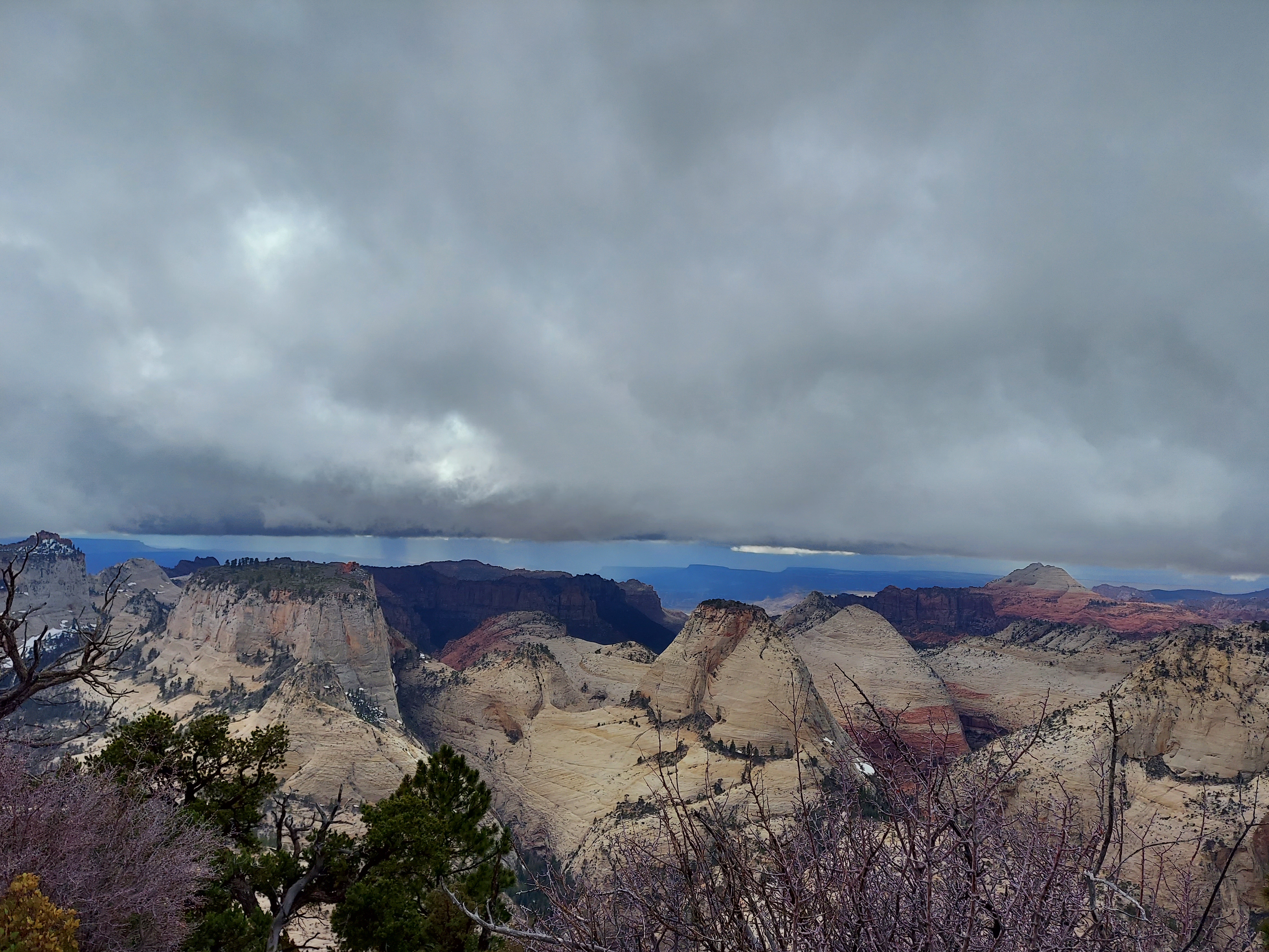
I see no one in my 24 hours beyond Cabin Spring. There are more climbs, but they are gradual, and the muck is indeed treacherous in places, first as an insidious yellow mud that isn’t thick but clings to boots like leeches on legs, and later in a thicker, gloppy ascent with a full-blown stream running down the middle. The views are stellar, or so I am forced to guess: I am in the clouds, the chances to see outward sporadic, and while the mesa here is exposed enough that most snow is off the trail, it still clings to shaded hillsides. The late winter landscape takes on a haunted, empty air, and phantom voices carry through the howling wind. I am as alone as I’ve ever been.
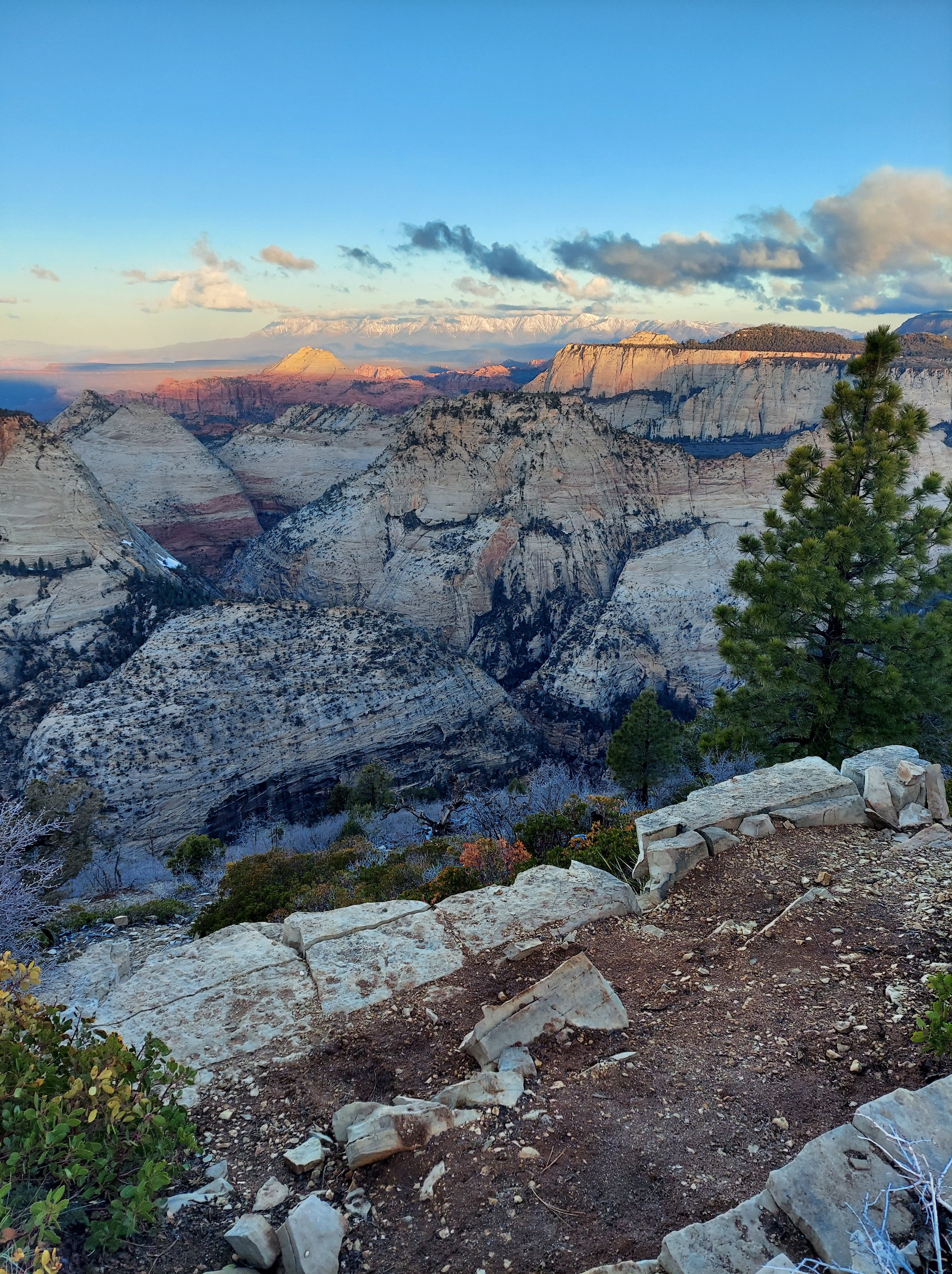
Finally, I arrive at campsite 5, which sits atop a ridge between Phantom Valley to the west and Telephone and Imlay Canyons to the east. The clouds whip directly over me and plunge my ridge into obscurity, and I pass the afternoon cycling from one side to the other, admiring the vista in whichever direction has the higher clouds at that moment. I don’t tire of it. In time, though, the thicker clouds get too close, and rain, interspersed with ice pellets, begins to fall. I have a tent malfunction, but some string and some rocks solve my dilemma and keep me dry through a 12-hour span under the covers. I sleep poorly, never warm but never exactly cold, yet somehow content that I have made it where I want to be. I rise at sunrise and finally look out to see the view from my throne atop Zion. The world glitters beneath me, ignited by a fiery glow. I am transfixed, my pilgrimage at its apex.
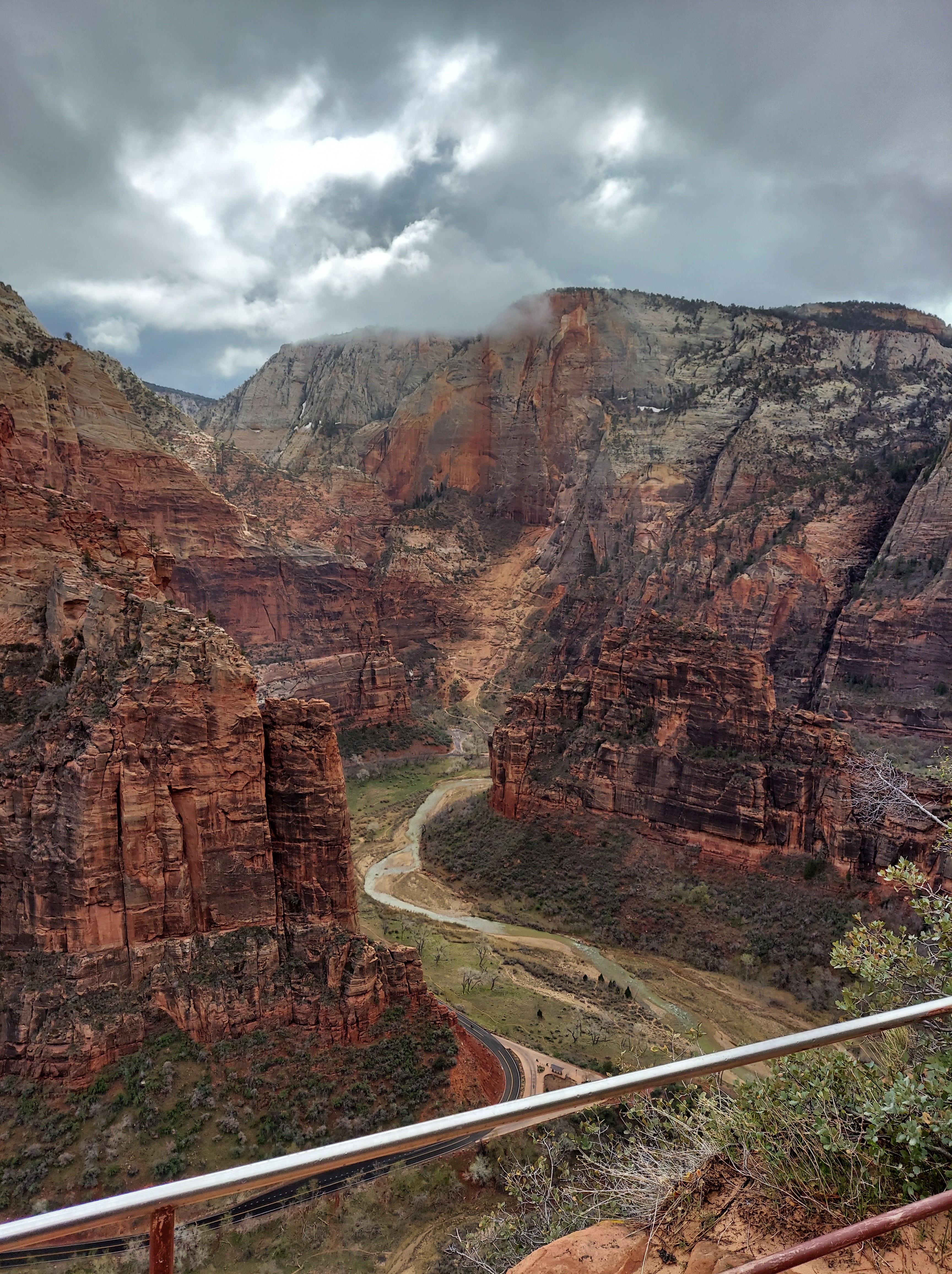
I wait until nearly ten to break camp so the sun can eat away at the ice on my equipment and dry out as much as it can. The trek down reveals all the views I’d missed the day before, made somehow more stunning by their temporary withholding, and I plow down in an hour less time than it took me to make the climb. Beyond the snowy bits I join a day-hiking couple from Beaver Bay, just an hour north of Duluth; we trade shared acquaintances as we go. Angels Landing is an absolute zoo, and I may have seen it at its absolute worst: in just two days, the National Park Service is finally imposing a permit system on the famed hike, and only the select, pre-scheduled few will be able to head up the chains. I fight the crowds down the switchbacks and settle for a half-mile stroll along the canyon bottom back to the Zion Lodge for a much-needed meal and a drink.
The Lodge is not quite what the doctor ordered for a weary hiker. The food has all the flavor of a McDonalds with none of the speed. There is only one beer on tap until the distributor’s truck arrives again, though at least it is a decent local microbrew. There are no open tables and alcohol is not allowed off the patio on to the inviting lawn, so I decamp on a wall by the beer stand until a departing couple takes pity on me. I pay it forward and let a couple from St. Louis join me, and we bond over our fondness for road trips and incredulity over the crowds. (Shouldn’t all these children be in school?!) I share my shuttle back down the canyon with a clump of high schoolers on some sort of Christian retreat, all of whom ignore the mask mandate and talk earnestly about what they are looking for in relationships. Is it bad that my instinct is to buy them a case of beer?
I return to my car and climb back up out of Zion, back through the Mount Carmel tunnel and then north on US-89. My abode for the next two nights is a no-frills roadside cabin some 20 miles west of Bryce Canyon, and my dinner that night comes at a family diner in the town of Panguich, a bustling joint staffed almost entirely by teenagers. From my spot at the bar, I get a front row seat to the chaos, as the POS system is deemed a POS and three orders come out for tables with no one sitting at them. At least the wings are tasty.
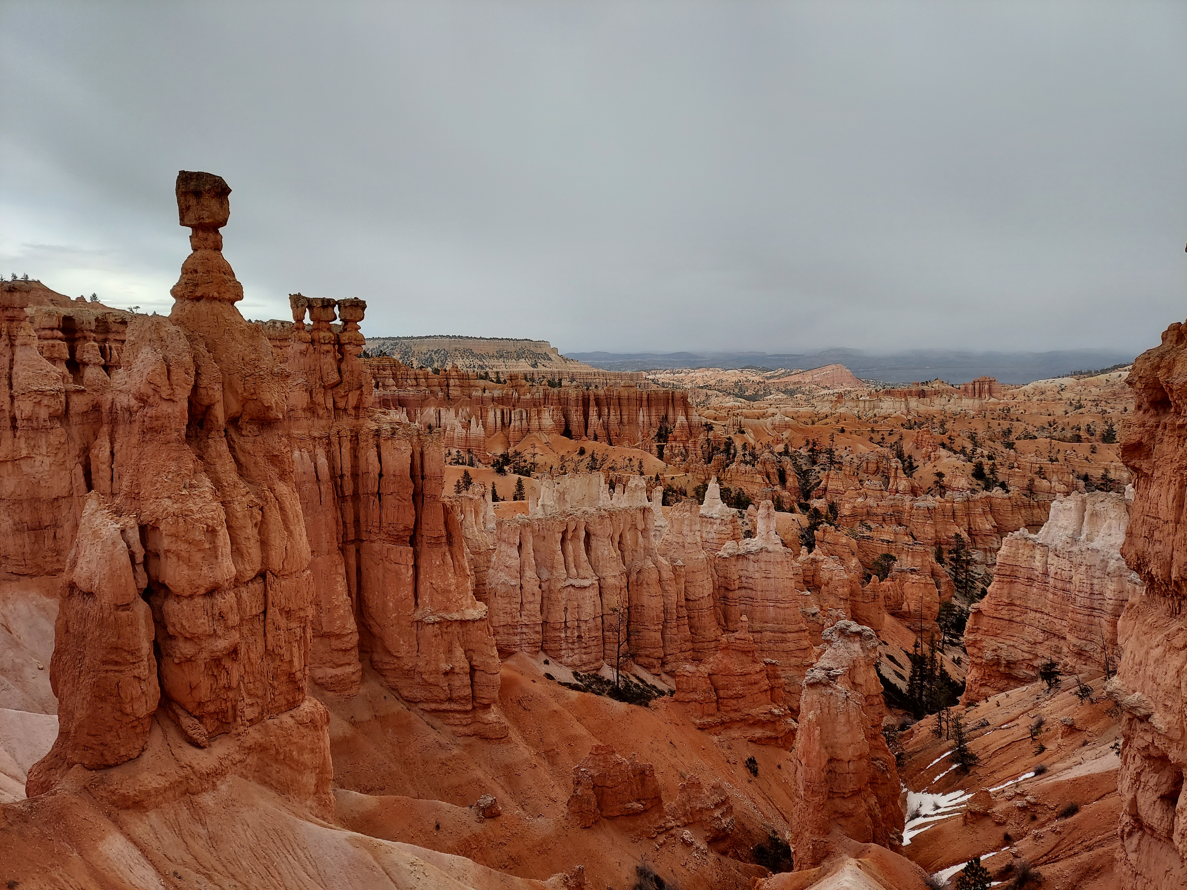
A poll of acquaintances who have visited both Zion and Bryce has been inconclusive on which is better. While Bryce cannot match the sheer scale of Zion, it has an intimacy to it, and its famed hoodoos never cease to amaze with their wild shapes. Trails chart labyrinthine courses around the pinnacles of rock, never flat as they wind down to the floor of the canyon and then back up and around to get over to the next feature. South of the bustling amphitheater, a 17-mile road snakes its way up past 9,000 feet in elevation, with repeated overlooks up and down the Grand Staircase and across the Paria River valley. It’s snowing when I arrive, and while it is a bit too warm for anything to accumulate, three more squalls break out over the course of the day. The most eventful one comes as I traverse the Bristlecone Trail at the far end of the scenic drive; the woman I am following loses the trail entirely for a spell. She is one of five lost people I help over the course of the day, and I can’t pass up the opportunity to lament the decline of navigational skills. “Trust me, I don’t get lost!” I want to yell at the dude making his second circuit of the Peek-a-Boo Trail even though he is sure he isn’t; later in the day, we meet at an overlook and he concedes defeat. Don’t mess with my geography skills.
The burst of wind and snow that nearly stole my hat away atop Bryce Point tells me it’s time to wrap things up here. I wrap up my Bryce hiking with a quick trot to an ice-filled cave off Highway 12, where dripping water produces a trickling symphony that silences the cluster of viewers. I am glad I saw Bryce, but in a day, I feel like I have seen what it has to offer, while after nearly a week in Zion across two trips, I still haven’t touched its northern unit or The Narrows or Observation Point or its little-known southern desert. I conclude my tour of Bryce with a geology lesson in the visitor center, content with a rock-filled day sandwiched between two experiences of wilderness sublime.

This entire trip is, in effect, a traverse of the Grand Staircase, a series of rock layers that rise up from the Grand Canyon and the Colorado River into central Utah. These different bands of geological time give the rocks different hues, often ending in dramatic dropping shelves. Closest to the Colorado are the Chocolate Cliffs, while the Vermilion Cliffs rise near Kanab, just south of the Utah-Arizona state line, and include the Coral Pink Sand Dunes, the areas around Colorado City, and the lower layers of Zion. Next come the White Cliffs, which look like a jagged scrape on an aerial image; they form Zion’s upper reaches. The drive from Zion to Bryce follows the cut of the Sevier River up through the Grey Cliffs, and finally, at the top, are the Pink Cliffs that reach the heights of Bryce at 9,000 feet. Above these sit the great upland plateaus of south-central Utah, themselves rising in steps: the Markagunt, the Paunsaugunt, and the Aquarius. The Staircase’s eastern railing is the Kaiparowits Plateau, which stretches down from the Aquarius to the Colorado and falls off on its own eastern side from the Straight Cliffs into the canyonlands of the Escalante River. It is in this remote land, the last portion of the lower 48 states to be mapped by the US government, that I will spend the bulk of the next two days.

The drive east from Bryce has the distinct feeling of heading deeper into the wilderness. I tumble down from the Paunsaugunt through a series of Mormon frontier towns in the Paria River valley, oasis outposts with verdant fruit trees clustering around dust-choked homes. The road winds up into the Kaipirowits and down through funky Escalante, traffic thinned to a trickle. My eagerness at this fresh landscape grows, but nothing quite prepares for the Head of the Rocks Overlook, where the scrubby plateau disappears and the rocky canyonlands of the Escalante River undulate out in all directions below, the ribbon of the CCC-built Highway 12 the only thing interrupting the march of these rocky waves out to a few snow-capped ranges on the fringes of the wilderness.
At the direction of a ranger, I head straight for the Calf Creek Campground and claim one of the 13 sites nestled just above that small stream’s confluence with the Escalante. I wish I could have arrived just two weeks later to see this small Eden at its best, but as it is, these oases in the desert are budding and coming to life. I plug up the creek some three miles to Lower Calf Creek Falls, a 120-foot plunge of water into a deep, cold pool. The route is gradual, with views to ancient pictographs and granaries up on cliffs, and while a healthy crowd hikes this trail, it has nothing on Zion or Bryce. I dip my feet in the icy waters and take my time to soak in the warmth on the stroll back.

After a recovery spell in a hammock, I drive north into Boulder. On the way, Highway 12 skirts high above Calf Creek and the canyonlands to the east, an Angels Landing for cars atop the ridge, and then plunges into Boulder, the last town in the US to have mule-delivered mail, accessible only by unpaved road until the 1980s. The Burr Trail, an old cattle route, swings east from here, and a cheery sign announces a mere 72-mile trip to the Lake Powell Ferry. The trek would take hours; I settle for a trip in to the aptly named Long Canyon, a deep red gash in the stone, and home to a lonely slot canyon worthy of a quick exploration. That night, back at Calf Creek, I hop up on a natural red rock seat, sip away at some wine, and drift into a reverie as the stars emerge, deep in this lonely desert, the crackling fires and stray laughs across the campground filling me with a warmth independent of the cool evening air.
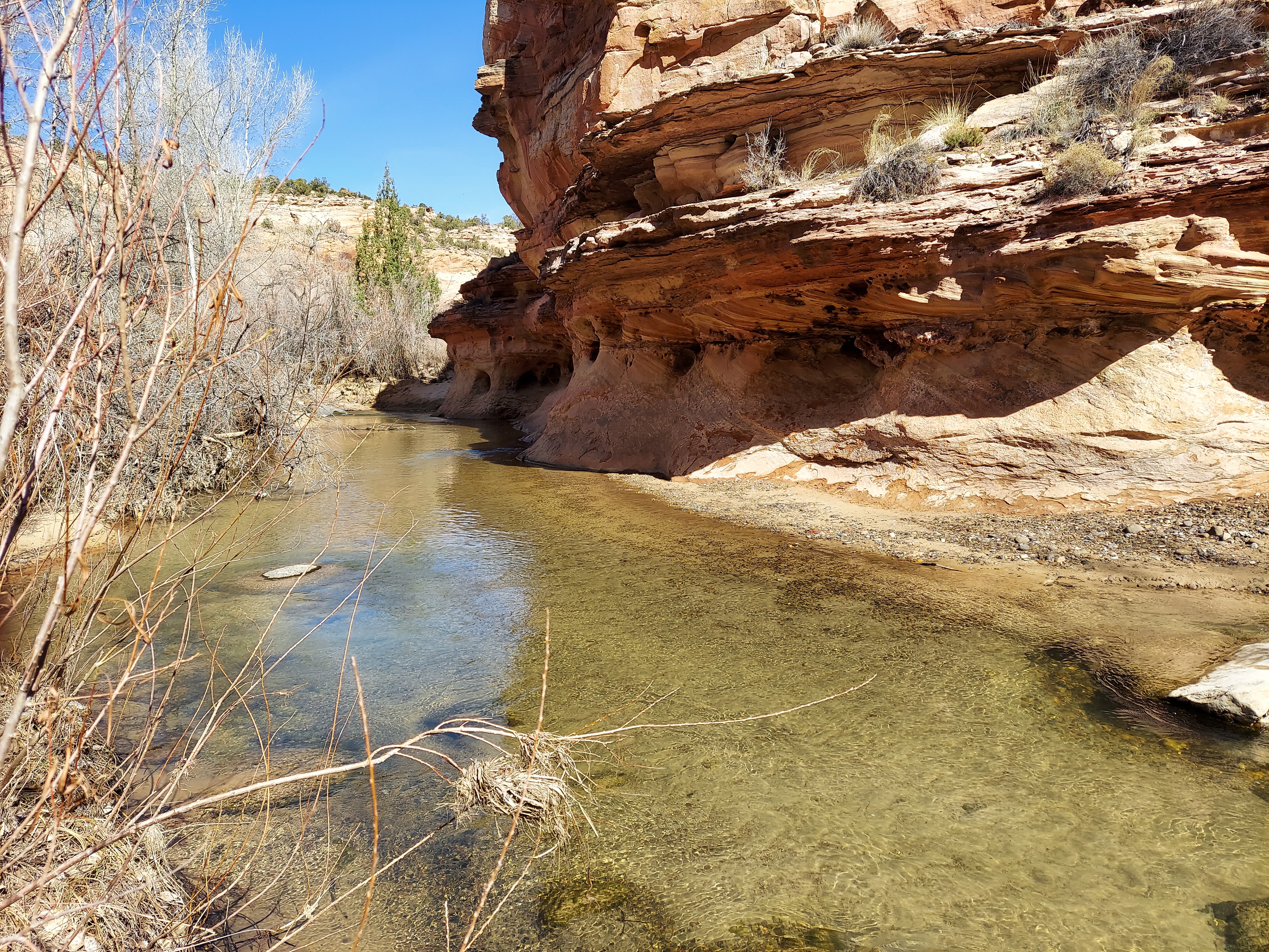
Some ice forms in the water bottle I leave out on the picnic table, but I have my soundest night of sleep in a tent on this trip. After packing up, I do a 6-mile stroll up and down the Escalante, wading its frigid waters 14 times as I process up the canyon to a natural bridge and an arch. The trail snakes along those pure flowing waters, up and down ledges and across dry washes, nestling beneath cliffs and cottonwoods and through fields of sage. All is at peace.
I take my time in making my exit from Grand Staircase-Escalante. First, another hiker mentions some unadvertised petroglyphs just above the parking lot by the river where I’ve been hiking, so I head up the trail opposite the river and, after a few false turns, arrive at these signs from the past. On the other side of the river, I pause for a scrumptious lunch at the Kiva Koffeeshop, a new agey wonder built right into the hill, with views up and down the canyon. Grand Staircase-Escalante is a beauty, Zion’s essence distilled to its basics and stripped of its crowds. I shall return.
