WRT V, Part 2: Into the Towers

This is part two in a three-part series. Part one is here.

For a sixth straight year, I am off on a western hiking adventure of overpacked food, bourbon, deep debate, and dramatic scenery. Stalwarts including Uncle Bob, cousin Rob, and friends Amy and Ed are here once again. Our numbers have swelled this year, as van-dwelling cousin Alex and his wife Meghan have timed their meanderings of the American West to join us. Jim, too, is back for the first time in three years, making for perhaps the largest party in the history of this crew.

We gather at Big Sandy Lodge, a resort at the end of a long, car-killing road high in the foothills of the Wind River Range in west-central Wyoming. A collection of spare cabins arcs around an opening in the pine forest, and a small lake frames the view to the nearest peak. The small lodge serves up hearty communal dinners and welcomes in exhausted hikers, and the proprietors’ toddler pulls books from the shelves and insists that I read them. (The first one he hands me is in French.) We lay out our meals on the single table in one of the cabins for the annual debate over necessary supplies, and we later enjoy drinks by oil lamp. We are at the edge of civilization, a final homely house on the frontier.

Eight hikers set out from Big Sandy Lodge the next morning, but a mile in, Jim concedes that physical ailments will keep him from enjoying this trip, and he makes the difficult decision to turn back. Nurse Meghan escorts him, and Alex and I hang with her pack while the other four press on. When we are reunited, Meghan, Alex, and I turn on the jets to catch up, but in our haste choose not to look at a map at the first fork. We thus end up on a path parallel to the one we want, and we are two miles in and beyond some pleasant lakes and mountain views before we appreciate our error. A backpacking backtrack ensues, and our first day adds four extra miles. For a second year in a row, this alleged master of maps has seen his group get hopelessly lost just a mile in. I hereby forfeit my credentials back to the National Geographic Society.

The correct trail is closer to the spurs of the mountains, up rises and past parks with nascent creeks, down a busy trail to Dads Lake, where we finally catch the waiting group. The Winds, we can see here, are not a secret: plenty of families roll in on fishing trips, including a horde of loud kids on the bluff right above our eventual campsite on Marms Lake. But some passersby tell us there is solitude just a bit onward, and the first steps on day two are promising.

The second day has generally become the most aggressive of these trips, and this year is no different. The sheer exhaustion may not match the Colorado Trail’s offering two years ago, but this one may be the most technical. It starts out innocently enough, as we make our way up a valley with a glittering creek that bubbles downward and swing past a series of lakes with sandy beaches, tempting us to stop for a swim. Sheer alpine beauty. We rise above the trees, skirt the aptly named Barren Lake and swing up to Texas Lake, the source of the stream nestled deep in a small cirque. Harsh peaks line its sides, but up one scree field a few figures slowly climb. This is Texas Pass.

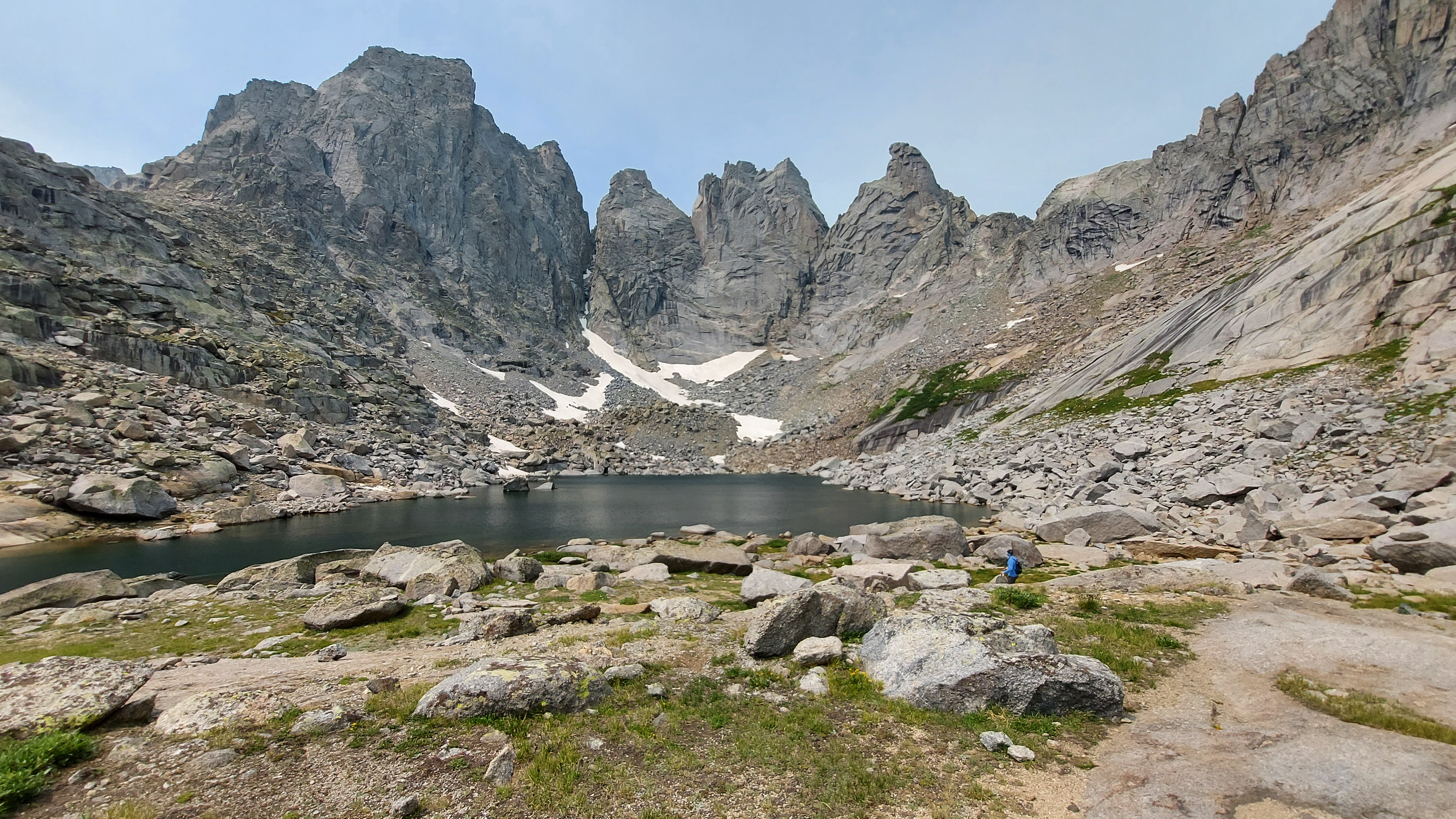
After a lunch break and ample incredulity over the path ahead, we make the slow plod up the 800-foot pass. Rob and I pick out the route up, call some guidance back downward. The adrenaline surges at the wind-blasted crest, and after some recovery we step forward into the Cirque of the Towers, the destination this trip, a beauty of a high-country bowl beneath stunning peaks and a haven for rock climbing virtuosos.

The Cirque’s serrated jaws wrap around Lonesome Lake, invisible in the depths below, and we traverse a small snow field and detour to an overlook above another stellar lake before we begin the descent. At first it is lovely, down rock ledges and past another dancing stream, to the point that we entertain camping up here before wisely choosing to plunge downward. This is a treacherous stretch of loose dirt and tentative footholds, less physically exhausting than the climb but perhaps more taxing, and the shores of Lonesome Lake can’t come quickly enough.

We make camp a quarter mile down the North Popo Agie River, Lonesome Lake’s outlet, amid some scrub where forest meets meadow. To the west, the Cirque, dominated by Pingora Peak just right of center, a striking granite pinnacle reminiscent of Devil’s Tower. Beyond it, a jagged ridgeline of rock-climbing conquests wraps southward to the sheer-faced massifs of Pylon, Warrior, and War Bonnet Peaks. To the east, a long run down the valley of the Popo Agie, peaks and cliffs lining the route and closing us in to the north and south. The last remnants of snow cling to the nooks where sheer faces meet boulder fields below, some of them permanent enough to count as glaciers.

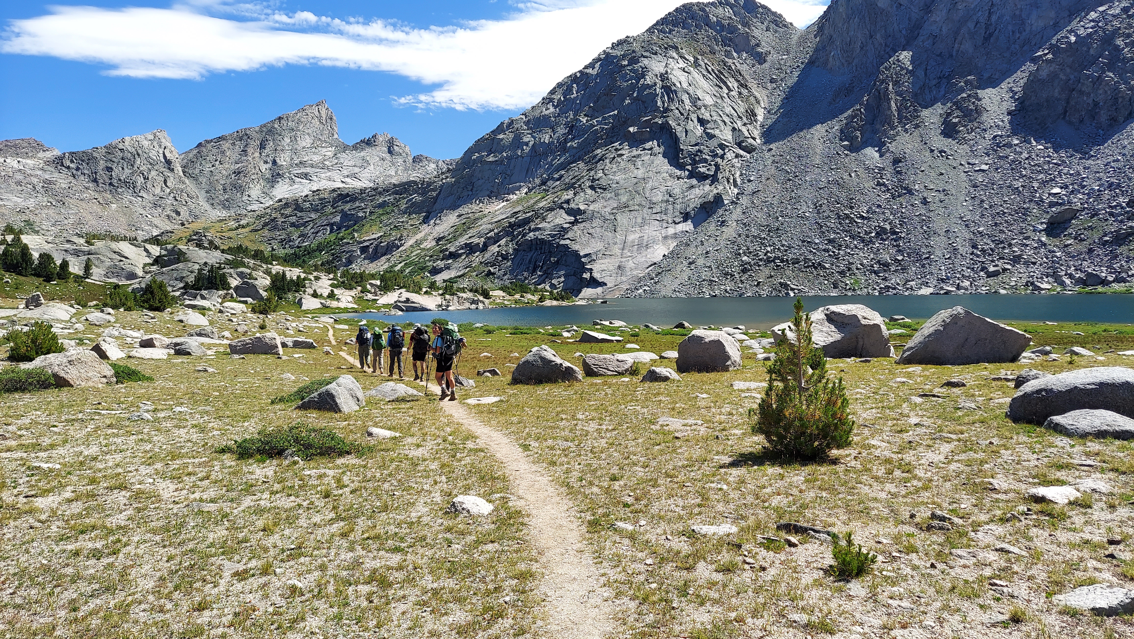
We spend two nights on the doorstep of the Cirque. A day hike on day three takes us around Lonesome Lake and into the upper reaches of this great bowl, on and off a semi-formal trail past additional tucked-away camps and a curtain waterfall. One thousand feet higher up, past a labyrinthine boulder field, is a mini-cirque with its own little lake and walls up to the heavens. Atop the jagged Shark’s Tooth, we pick out two ant-sized climbers summiting the peak. When in shade some of the spires look ominous, the guardians of some dark lord’s land in a fantasy series, an otherworldly sinister beauty that has me thinking this may be our most stunning single destination on any one of these trips.

On day four I wake to a drip of water in the face, condensation seeping through the rain fly and dropping to touch the tent fabric. I step out and gaze up at the fog hanging over the Cirque, coming and going as it obscures peaks and slowly lifts. In moments like this nature kills any sense of time, just invites a steady gaze until the magic breaks. After breakfast we push up Jackass Pass, the tamer southern gateway to the Cirque, and bid its spires farewell. Arrowhead Lake poses a choice: either clamber back up a promontory and slide down a Texas Pass-type slope, or swing west along the lakeshore through a boulder field. In keeping with our theme of the trip, we choose the boulders, swinging across gaps, sitting to sink into a passageway or clambering to rise above the furtive crevasses.

Next is a long plunge down to North Lake, followed by yet another rock scramble. On a spire to the right, climbers work their way up a sheer face. Up the trail come all manner of hikers seeking the Cirque: backpackers with bold itineraries, young couples with climbing ropes, day trippers from Big Sandy Lake, teenage fishermen, and a bachelorette party of 11 in matching Wild Women of the Winds hats and their five dogs. One last big drop brings us to the tent-dotted shores of Big Sandy Lake, and we pick out a campsite atop a small rise over the lake where we polish off the bourbon and play cards deep into the night.

The final day of hiking is, after the past few days, an easy stroll downhill, though thick forests and the occasional pleasant meadow along the Big Sandy River keep it lively. It is easy, that is, until the final half mile. Over the course of this trip Rob’s CalTopo app has saved us at numerous crossroads where the paper maps fall short. This time, however, it outdoes itself, and we are left picking our way through a bevy of downed timber and over awkward rocky knobs. Juicy burgers and beer await at Big Sandy Lodge, however, and we unwind, reconnect with Jim, trade stories with three hikers who have been in deep over the past week. It has been another hiking triumph, another journey well-spent, and I head east again in full belief in the power of these wildernesses to take us to new heights.

Part 3 is here.

Western Road Trip V, Part 1: Blank Space

This is the first in a three-part series on a western road trip.

I go east for civilization, for history and culture and the roots of memory. I go west for new beginnings, for the freedom to make sense of that jumbled inheritance.

And so westward I go once again, across Minnesota and eastern North Dakota, back across these roads I am starting to know well. A road trip across the Dakotas and eastern Montana and much of Wyoming may invoke thoughts of monotonous and dullard landscapes, and there is certainly some of this. But some part of me is now drawn to this seemingly blank space, these hardscrabble towns, to people on plains that go on forever, once a frontier but now planted in the middle of an expansive land.

I fly across Minnesota and eastern North Dakota with few stops and spend an unremarkable night in Bismarck. The next morning I pay my respects at Salem Sue, the silent sentinel at the entrance to the West, and take in the first tentative buttes hinting at the hills and mountains to come. After numerous past visits to the South Unit of Theodore Roosevelt National Park, I swing off the freeway in Belfield and head for the North Unit. The basics here are much the same, badlands lining the floodplain of the Little Missouri River, scars and pockmarks interrupting the flatlands and beckoning the visitor in. Bison clump along the road and sometimes in the middle of it, and the campground is maybe half full on a Friday night.

I subject myself to a four-mile loop hike in triple-digit afternoon heat. The trail is mostly exposed, shooting straight up the sides of a coulee to vistas of the Little Missouri, where a few bison have taken refuge from the heat. Mercifully, the back side of the loop tucks into some juniper thickets that provide a reprieve from my blossoming sunburn, and I’ve found a campsite that has trees on all sides. Even the scattered sun hitting the hammock is miserable, so I park my camp chair atop my cooler in the shade of the trunk of the largest cottonwood I’ve ever seen and slowly rotate it to stay out of those cruel rays. My new camp gear is enough to earn me some sleep despite the heat, and I do not linger long the following morning, shooting west through the bleak impermanence of North Dakota oil country and down a long stretch of the Yellowstone River before a dive south into the Bighorn Basin.

Behind the Front Range of Colorado and the Bighorns in Wyoming, in front of the great ranges of Utah and Idaho and Montana and Yellowstone, is one of the emptiest corridors in America. It stretches from the Four Corners region in the south to the Yellowstone River in the north, 600 miles of parched country, some of the driest in the nation except along its ribbons of river: the Colorado and the Green in the south, the Bighorn in the north, these powerful waters punching through mountain ranges that separate the basins in this lonely land.

The Wind River Range is a protrusion into these inhospitable climes, thrusting south and east from the Tetons, and it is the 2024 destination for my annual hiking party. The Winds are not really near anything, and that is part of the allure for our journey this year. I spend my last night in the relative lowlands in a town selected because its name sounded fun. But it turns out to be more than that.

Thermopolis, Wyoming strikes me as a triumph of what the West can be. A town of just 3,000 people, it has the good fortune sit right where the Bighorn River slips out of the Wind River Canyon (the Bighorn and the Wind are, in fact, the same river), and the world’s largest mineral hot spring bubbles up beside it dumps on in. The area around the hot spring is a state park, guaranteed free for use by an age-old US government treaty with the Shoshone and the Arapaho, and I happen to visit during Discovery Days, which has a host of Native families picnicking on the sulfurous grounds around the spring. On this 100-degree day I am not too enthused about a dip in 105-degree water, so I make do with a stroll about to drink in the scene, and am too late to see the town’s top-notch dinosaur museum, too. Downtown Thermopolis has bustling shops and a surprising degree of culinary variety and a respectable brewery, where I post up at the bar and meet a couple completing the woman’s cross-country move to be with her snowboard guide partner in Jackson, and later two fishermen from Cheyenne. The snowboarder wins a few hundred dollars in a dice game jackpot, and the five of us watch Olympics and play dollar-ante dice games after that. It is a night well-spent in a town that pulls together the various strands of Western life and makes them into something whole.

From Thermopolis I head up canyon and into the Wind River Reservation. Here the Northern Arapaho and the Eastern Shoshone have land along the Wind and its merging tributaries with names like Poison and Badwater Creeks, which are in fact the two streams flanking the town of Shoshoni. This is deep rural country, though larger towns like Riverton and Lander have cropped up just off the reservation checkerboard and provide some services. From here I head up the old wagon trail route over South Pass and turn off on a steadily deteriorating dirt road into the Wind River Range, where my backpacking party will head for the Cirque of the Towers.

The rest of my fellow hikers head back to Salt Lake City after our hike, either to fly home or to carry on with their van life adventures across the West. My road back, however, is a long but purposeful one. After my descent from the Winds I head east to Casper, over rolling steppes of Wyoming sagebrush beneath moody skies, a pinprick within the great openness of the West. Early 1800s explorers called this land between the 100th Meridian and the Rockies the Great American Desert, and though it can be monotonous, the austere beauty here fills some hunger, some knowledge that these wastes hold some secrets and that crossing them can unlock some greatness.

I stop at Independence Rock and the National Historic Trails Interpretive Center, markers on old roads west, monuments to the toll these lands once exacted on those chasers of western dreams. Now, I shoot across them in a matter of hours, endure dreary Casper and then spend the next night in Hot Springs, South Dakota, where I see a collection of mammoth remains interred here on the southern end of the Black Hills. Most Western towns tend toward the simple, the impermanent, just the basics set up here to provide the necessities. But they also feel the past deeply, their stories told by the events that once happened here, and they guard these stories better than in the east or the far west where it might be paved over, subsumed by the march of progress. Instead progress drifts through here from time to time, leaves its mark but tends to move on, and the West eases back into a more timeless state.

The next morning I head toward the Pine Ridge Reservation, an experience that deserves its own post. But after that the rest of the drive across South Dakota passes easily enough. Grazing cattle beget sunflower fields beget corn and wheat. There is some momentary Badland delight before Kadoka, a swing past a second Dakota capitol building, and a skirting of some pleasant lakes to break up the endless fields and tired farm towns with a few nice new houses on the outskirts.

I spend my final night of travel at Lac qui Parle State Park, just across the Minnesota border, in a walk-in campsite amid prairie grasses with a view down to the lake that speaks. It is a perfect evening, and I write easily, the crickets amid the oak savanna pulling me back to some of my deepest-rooted snippets of memory, of warm summer nights outside Madison. (Wisconsin, that is: Madison, Minnesota is the nearest town to Lac qui Parle.) The campground is quiet, mostly empty, but a couple of fires crackle and a warm glow emanates from the camper cabins. A few Pleiades streak overhead. Worries drain away, nagging doubts fall into nothing. I have faith and I have a mission, and a blank space in which to write a name.

Part 2 is here.

Into the Western Well

It is August. After a social spring and summer, it is time for my annual retreat to a wilderness in the West. Bob, Rob, Amy, Ed, and I are ready to disappear into the mountains yet again. It is my fifth time joining this group on its yearly venture, and this time around I saddle the group with an itinerary in a new mountain range I’d seen from a distance and deemed worth exploring. We are off to the Cloud Peak Wilderness in the Bighorn Mountains of Wyoming.

The Bighorns stand to the east of the Rockies as a lonely outpost of high elevation, a prominent range separated from others by twin vast open expanses, the Absarokas by the Bighorn Basin to the west and the Black Hills by the Powder River Basin to the east. They sit far from any other major attraction, save perhaps a road tripper’s route to Yellowstone and the Tetons and the Little Bighorn battlefield. The two gateway towns, Sheridan and Buffalo, combine for about 20,000 residents (granted, a veritable metropolis by Wyoming standards) and little of the seasonal surge in population that descends on other high country access points we’ve visited in the past, such as Red Lodge in Montana or Leadville in Colorado. They feature no national park or monument, no 14,000-foot peaks, no iconic roadside attraction to lure in the I-90 road trippers, many of whom may now even take the Google Maps-endorsed bypass on US 212 from Spearfish to Crow Agency, thereby avoiding Bighorn country entirely. For that matter, the range’s namesake sheep, decimated by early white settlers, have only been reintroduced in one northern pocket of the mountain chain.

What the Bighorns are is a rougher edge of wilderness. Here we find more extreme weather, more creek crossings, more horse poop, and bigger boulder fields than we have seen elsewhere. We find both solitude and trails more traveled, and a smorgasbord of Western experience, from rough frontier edges to the encroachment of coastal cosmopolitan comfort, from wide open freedom to the memory of loss that lingers in places like the Crow Reservation we drive through on the way to the trailhead. These rocky slopes provide everything a good hike should.

The hike goes awry quickly. After a leisurely stroll from the Hunter Trailhead on a rough road used by horses and ATVs, we take the alleged scenic route on the Ditch Trail, whose name alone should have been a warning. It starts out clear but muddy, tracking a flume-like creek running down from the mountains, but after we cross it, we promptly lose the trail and end up whacking through a dense thicket of 20- to 30-year-old pines as it begins to rain and hail. GPS gets us back on the putative path, but it clearly had not been maintained in years, as we are left to circumnavigate thousands of down trees and miserable swamps that afflict the occasionally visible ditch that give the trail its name. We are lucky this is day one and we have the energy for this slog.

Once we get back another horse and ATV road, we can finally cook along through mid-altitude forests and across alpine meadows, past the graves of a few lonely frontiersmen and through variable precipitation before we land at a respectable campsite near a creek crossing. It clears up enough to enjoy the evening, and a large moose cow wanders by after dinner. Day two is day of creek crossings as we head higher up Florence Pass, a steady push upward with pauses to step gingerly through frigid waters. The rain and hail hits on an exposed stretch of rocky trail above 10,000 feet, and we take shelter in a cave just large enough for the five of us, where we wait out the worst of the storm and eat lunch. Rob’s garbage bag turned pack cover blows off down the canyon, Amy is quite done with creek crossings, and when we get to Florence Lake, our planned destination for the evening, we discover a rock-strewn, barren shoreline with near zero flat ground to pitch a tent.

Not enthusiastic to go any further, we scope out some halfway acceptable tent pads up a slope from the lake and make camp. Despite its obvious deficiencies, Florence Lake is a beautiful place to settle: stellar waterfalls tumble into the pristine waters, and the mountains glow golden at dusk as the sun finally emerges from the clouds. Across the lake are the wide arms of Bomber Mountain, on whose slopes a World War II era warplane’s remains lie; behind us is Florence Pass, the high point of our hike at 11,000 feet, and a commanding view of the lakes down the next valley is just a short stroll away. It is a chill night, frost on the tents and pack covers in the morning, and the need to thaw it all out becomes our excuse for our usual slow exit from camp.

On day three we descend from Florence Pass along a series of lakes before we come to the busier corridor that links the West Tensleep Trailhead (our exit point) with Mistymoon Lake and the trail up Cloud Peak. We have found the open high country at the heart of the Bighorns, and finally, the weather cooperates and gives us free sightlines of rocky peaks and tangled heath and a series of brilliant lakes. A giant bull moose hugs the shoreline of Mistymoon, and we score a prime campsite at the base of a base of a waterfall in a valley that serves as a staging bowl for assaults on Cloud Peak. All trails in the southern Bighorns seem to lead to this small stretch, and for good reason.

After two days of solitude, we know we’re in for a different experience when we encounter a herd of horsemen all conspicuously packing heat. On our other hikes, most of the people we encounter are typecast backpackers: young adventurers, veteran wilderness explorers, people who seem born to be part of nature. In the Bighorns, we find much a greater variety: a lot of families, some salt of the earth locals, a general excess of cowboy hats, and in one case a kid hiking in cowboy boots. We admire the dad from New Mexico with his three backpack-toting kids, ages nine, six, and five, all cheerily bearing their loads and off on fishing excursions in the alpine lakes. The fellow travelers we get to know best are Brandi, a Wyoming native whose parents have finally accepted her itinerant lifestyle, and Oliver, her Salvadoran partner with roots in Brittany. They met when Brandi signed up to crew Oliver’s sailboat in Grenada and they have since traded sailing for the van life, which has now led them to the Cloud Peak Wilderness. We share a site with them for a night, and suddenly we are discussing sailing and Salvadoran politics and migration and gang violence over our respective freeze-dried and packaged delicacies.

On day four, Bob, Amy, and Ed take it easy with a day hike to Solitude Lake, while Rob and I wait out a thunderstorm before we tackle Cloud Peak, the highest point in the Bighorns. While its summit at 13,171 feet doesn’t rival the Rockies’ fourteeners, this push upward is substantially harder than our conquest of Colorado’s Mount Massive a year ago. Part of it is a route problem: several people we chat with and a guide I’d read suggested that, on the way up, we should cling to the ridge on the right. This advice, in the words of a Scandinavian man we chat with high on the saddle who’d followed the same guidance, is “moronic shit.” It results in an extra hour of bouldering instead of a fairly straightforward surge up along a creek and an easy runoff ramp, albeit with some impressive views.

Even so, the bouldering is inevitable over the last 1,500 feet of the climb, up through crags and around crevasses and past the few snow fields that linger late into August. We summit around 2:30 PM, blasted by winds gusting up to 50 miles per hour, and begin the steady rock hop down. The slopes are relatively empty: besides Rob and I, the climbers on this day include the Scandinavian man and his Asian wife (plus their teenage son, who bails at the saddle), Brandi and Oliver, a family with a dog who make the whole affair look like a walk in the park, and three similarly sprightly young men, their footwork as they dance from boulder to boulder leaving me in awe. On the way back we cruise down the ramp but are still left with some rough scrambles as we sort our way through the haphazard cairns marking the route.

After a second night at the foot of Cloud Peak, we hike the eight miles out down West Tensleep Creek. The first half is a scenic stride past three lakes shimmering in the sun, but the final four miles are more of a slog through woods and mud, though they are livened up by an ongoing game of tortoise and hare we play with a group of teenagers and their handlers. Their antics at a final crowded stream crossing leave Bob and Ed, longtime guides of boy scouts on camping excursions, reliving old dramas. Finally we stumble out to a crowded trailhead, back to civilization and backlogged emails and requests for my takes on a shocker in Duluth’s mayoral primary.

We begin and end our journey in Billings, home to the nearest airport of substance. It is a regional center; on an east-west axis, it is the largest thing between Fargo and Spokane, and the spot where two major cross-country interstates meet. This status gives it some good institutions for a hub of its size, a crossroads of industry whose main draw is its proximity to other things. In my previous three visits I saw it only as a launch point, but as we spend some time here this time around, its culinary scene throws in some genuine surprise. Juliano’s, a converted old home with a Hawaiian chef, is one of those small city strivers ahead of its curve, brilliant but underappreciated. The Granary, in spite of its barnlike structure, provides a little window into Mediterranean basin fine dining. As a fervent defender of Billings-size cities, I applaud the progress here on the western edge of the Great Plains, though I am sure a few locals can only shake their heads.

I think back to three years ago, when I first drove these open roads around Billings. It was deep in the Covid summer of 2020, and the West felt like the land of restless freedom and sorrow that has formed its myth. This time, we debate several forms of life on display here. There is the gun-toting machismo, most charitably viewed as an extension of a brave frontier ethos and a can’t-be-too-safe caution in a land where crime is rare. On the flip side is a fetishistic continuation of a lone wolf myth, to say nothing of the solitary lives ended late on lonely nights on the prairie. (Wyoming has the dubious distinction of the nation’s highest suicide rate five years running, with Montana right behind. The correlation between firearms and the completion of a choice not to be is not hard to see.) And then it will always attract the Brandis and Olivers too, the free spirits who find, in its vast open spaces and its growing subcultures, a place where they can live cheaply and freed from societal constraints, at liberty to roam and shed obligations to the past. Is their way of life a bold pursuit, or a frivolous retreat from the commitments that give a life meaning? Opinions differ among the five of us, all urbanites with comfortable careers who make an annual escape; time may also render such questions moot. For now, the West accommodates them all, and at its best gives families like our New Mexican friends a playground to raise kids to explore and achieve away from the monotony of overprotection and screen life.

For us, however, it is just a snippet, a taste of the wilderness that can carry us through for another year. Before next time I have new gear to buy and routes to plan, and after a summer with a lot of time on the road, I am ready to settle back in to Minnesota life for a spell, too. Until then, the West will linger there for us, that allure eternal.